|
|
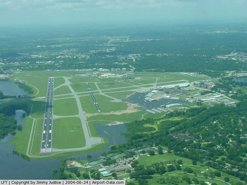
Lafayette Regional Airport |
| Lafayette Regional Airport |
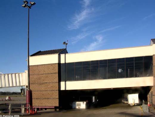 |
| Lafayette Regional Airport terminal from the tarmac |
| IATA: LFT â ICAO: KLFT â FAA LID: LFT |
| Summary |
| Airport type |
Public |
| Operator |
City & Parish of Lafayette |
| Serves |
Lafayette, Louisiana |
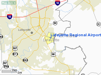
| Location |
Lafayette Parish, near Lafayette, Louisiana |
| Elevation AMSL |
42 ft / 13 m |
| Coordinates |
30°12â²19â³N 091°59â²15â³W / 30.20528°N 91.9875°W / 30.20528; -91.9875 |
| Website |
www.LFTairport.com |
| Runways |
| Direction |
Length |
Surface |
| ft |
m |
| 4L/22R |
4,099 |
1,249 |
Asphalt |
| 4R/22L |
7,651 |
2,332 |
Asphalt |
| 11/29 |
5,400 |
1,646 |
Asphalt |
| Helipads |
| Number |
Length |
Surface |
| ft |
m |
| H1 |
50 |
15 |
Asphalt |
| Statistics (2006) |
| Aircraft operations |
114,303 |
| Based aircraft |
159 |
| Sources: airport website and FAA |
Lafayette Regional Airport (IATA: LFT, ICAO: KLFT, FAA LID: LFT) is a public use airport located two nautical miles (4 km) southeast of the central business district of Lafayette, a city in Lafayette Parish, Louisiana, United States. It is owned by the City & Parish of Lafayette.
It is located on US Highway 90, on the southeast side of the city, in a population center close to the petroleum wells of the Gulf of Mexico. Lafayette Regional is home to the largest helicopter company in the world, PHI, Inc. (formerly Petroleum Helicopters International). Although the airport does not currently have international flights, it flies into four major hubs in the south: Atlanta, Dallas, Houston and Memphis. The airport serves the Lafayette Metropolitan Area, which consists of approximately 530,000 people. Facilities and aircraft
Lafayette Regional Airport covers an area of 746 acres (302 ha) at an elevation of 42 feet (13 m) above mean sea level. It has three asphalt paved runways: 4L/22R measuring 4,099 x 75 feet (1,249 x 23 m), 4R/22L measuring 7,651 x 150 feet (2,332 x 46 m), and 11/29 measuring 5,400 x 148 feet (1,646 x 45 m). It also has one helipad measuring 50 x 50 ft (15 x 15 m).
For the 12-month period ending February 28, 2006, the airport had 114,303 aircraft operations, an average of 313 per day: 38% general aviation, 36% air taxi, 24% commuter/cargo, 2% military and 1% scheduled commercial. At that time there were 159 aircraft based at this airport: 57% single-engine, 27% multi-engine, 9% jet and 7% helicopter.
Airlines and destinations
| Airlines |
Destinations |
| American Eagle |
Dallas/Fort Worth |
| Continental Express operated by ExpressJet Airlines |
Houston-Intercontinental |
| Continental Connection operated by Colgan Air |
Houston-Intercontinental |
| Delta Connection operated by Atlantic Southeast Airlines |
Atlanta |
| Delta Connection operated by Pinnacle Airlines |
Memphis |
World War II
The airport opened in April 1940. On 5 July 1942, during World War II, the airport was taken over by the United States Army Air Forces and used as a contract primary pilot training airfield under the AAF Gulf Coast Training Center (later Central Flying Training Command). The 384th Army Air Force Base Unit administered the contract to a civilian operated primary flying school (Lafayette School of Aeronautics) as a sub-base of DeRidder Army Airbase, Louisiana. Had four axillary airfields nearby for emergency and overflow landings. Flying training was performed with Fairchild PT-19s as the primary trainer. Also had several PT-17 Stearmans and a few P-40 Warhawks assigned.
Transferred from jurisdiction of DeRidder AAB to Esler Army Airfield (Third Air Force) on 24 March 1944. Mission of base became training of replacement combat aircrews. Inactivated 30 September 1945 and airport returned to civil control.
The above content comes from Wikipedia and is published under free licenses – click here to read more.
|
 |
(Click on the photo to enlarge) |
Location &
QuickFacts
|
FAA
Information Effective: |
2008-09-25 |
|
Airport
Identifier: |
LFT |
|
Airport
Status: |
Operational |
|
Longitude/Latitude: |
091-59-15.4000W/30-12-18.9000N
-91.987611/30.205250 (Estimated) |
|
Elevation: |
42 ft / 12.80 m (Surveyed) |
|
Land: |
746 acres |
|
From
nearest city: |
2 nautical miles SE of Lafayette, LA |
|
Location: |
Lafayette Parish, LA |
|
Magnetic Variation: |
03E (1990) |
Owner & Manager
|
Ownership: |
Publicly owned |
|
Owner: |
City Parish Of Lafayette |
|
Address: |
200 Terminal Dr
Lafayette, LA 70508 |
|
Phone number: |
337-266-4400 |
|
Manager: |
Greg Roberts Aae |
|
Address: |
200 Terminal Dr
Lafayette, LA 70508 |
|
Phone number: |
337-266-4400 |
Airport
Operations and Facilities
|
Airport
Use: |
Open to public |
|
Wind
indicator: |
Yes |
|
Segmented Circle: |
Yes |
|
Control
Tower: |
Yes |
|
Lighting
Schedule: |
DUSK-DAWN
WHEN ATCT CLSD ACTVT MALSR RY 22L - CTAF; MIRL RY 04L/22R NOT AVBL. |
|
Beacon
Color: |
Clear-Green (lighted land airport) |
|
Sectional chart: |
Houston |
|
Region: |
ASW - Southwest |
|
Boundary
ARTCC: |
ZHU - Houston |
|
Tie-in
FSS: |
DRI - De Ridder |
|
FSS on
Airport: |
No |
|
FSS Toll
Free: |
1-800-WX-BRIEF |
|
NOTAMs
Facility: |
LFT (NOTAM-d service avaliable) |
|
Certification type/date: |
I B S 05/1973
PPR FOR UNSCHEDULED ACR OPNS WITH MORE THAN 30 PSGR SEATS 2230-0600
CALL AMGR 337-266-4400; FOR EMERGENCIES BTN 2230-0600 USE FREQ 121.5. |
|
Federal Agreements: |
NGPY3 |
Airport Communications
|
CTAF: |
118.500 |
|
Unicom: |
122.950 |
Airport Services
|
Fuel
available: |
100LLA
100LL SELF-SERVICE AVBL. |
|
Airframe
Repair: |
MAJOR |
|
Power
Plant Repair: |
MAJOR |
|
Bottled
Oxygen: |
LOW |
|
Bulk
Oxygen: |
HIGH |
|
Runway Information
Runway 04L/22R
|
Dimension: |
4099 x 75 ft / 1249.4 x 22.9 m |
|
Surface: |
ASPH, Good Condition |
|
Weight Limit: |
Single wheel: 25000 lbs.
Dual wheel: 32000 lbs. |
|
Edge Lights: |
Medium |
|
|
Runway 04L
|
Runway 22R
|
|
Longitude: |
091-59-33.0670W |
091-59-03.8197W |
|
Latitude: |
30-12-05.7931N |
30-12-37.4250N |
|
Elevation: |
41.00 ft |
41.00 ft |
|
Alignment: |
39 |
127 |
|
Traffic
Pattern: |
Left |
Right |
|
Markings: |
Non-precision instrument, Good Condition |
Non-precision instrument, Good Condition |
|
Crossing
Height: |
25.00 ft |
25.00 ft |
|
VASI: |
2-light PAPI on left side |
2-light PAPI on left side |
|
Visual
Glide Angle: |
3.00° |
3.00° |
|
Runway End
Identifier: |
Yes |
Yes |
|
Obstruction: |
27 ft tree, 996.0 ft from runway, 83 ft left of
centerline, 29:1 slope to clear |
54 ft tree, 2364.0 ft from runway, 5 ft right of
centerline, 40:1 slope to clear |
|
Decleard
distances: |
Take off run available 4099.00 ft
Take off distance available 4099.00 ft
Actual stop distance available 4099.00 ft
Landing distance available 4099.00 ft |
Take off run available 4099.00 ft
Take off distance available 4099.00 ft
Actual stop distance available 4099.00 ft
Landing distance available 4099.00 ft |
|
Runway 04R/22L
|
Dimension: |
7651 x 150 ft / 2332.0 x 45.7 m |
|
Surface: |
ASPH, Good Condition |
|
Surface
Treatment: |
Saw-cut or plastic Grooved |
|
Weight Limit: |
Single wheel: 140000 lbs.
Dual wheel: 170000 lbs.
Dual tandem wheel: 290000 lbs. |
|
Edge Lights: |
High |
|
|
Runway 04R
|
Runway 22L
|
|
Longitude: |
091-59-34.6749W |
091-58-40.0956W |
|
Latitude: |
30-11-48.2269N |
30-12-47.2809N |
|
Elevation: |
39.00 ft |
33.00 ft |
|
Alignment: |
39 |
127 |
|
ILS Type: |
ILS/DME |
ILS/DME |
|
Traffic
Pattern: |
Right |
Left |
|
Markings: |
Precision instrument, Fair Condition |
Precision instrument, Fair Condition |
|
Crossing
Height: |
50.00 ft |
53.00 ft |
|
VASI: |
4-light PAPI on left side |
4-light PAPI on left side |
|
Visual
Glide Angle: |
3.00° |
3.00° |
|
RVR
Equipment: |
rollout |
touchdown |
|
Approach
lights: |
|
MALSR |
|
Runway End
Identifier: |
Yes |
|
|
Obstruction: |
49 ft pole, 1843.0 ft from runway, 325 ft right of
centerline, 34:1 slope to clear |
57 ft trees, 1066.0 ft from runway, 214 ft right of
centerline, 36:1 slope to clear |
|
Decleard
distances: |
Take off run available 7651.00 ft
Take off distance available 7651.00 ft
Actual stop distance available 7651.00 ft
Landing distance available 7651.00 ft |
Take off run available 7651.00 ft
Take off distance available 7651.00 ft
Actual stop distance available 7651.00 ft
Landing distance available 7651.00 ft |
|
Runway 11/29
|
Dimension: |
5400 x 148 ft / 1645.9 x 45.1 m |
|
Surface: |
ASPH, Good Condition |
|
Surface
Treatment: |
Saw-cut or plastic Grooved |
|
Weight Limit: |
Single wheel: 85000 lbs.
Dual wheel: 110000 lbs.
Dual tandem wheel: 175000 lbs. |
|
Edge Lights: |
Medium |
|
|
Runway 11
|
Runway 29
|
|
Longitude: |
091-59-53.2942W |
091-58-55.4690W |
|
Latitude: |
30-12-27.5449N |
30-12-09.2458N |
|
Elevation: |
37.00 ft |
36.00 ft |
|
Alignment: |
110 |
127 |
|
Traffic
Pattern: |
Right |
Left |
|
Markings: |
Non-precision instrument, Good Condition |
Non-precision instrument, Good Condition |
|
Crossing
Height: |
35.00 ft |
35.00 ft |
|
VASI: |
4-light PAPI on left side |
4-light PAPI on left side |
|
Visual
Glide Angle: |
3.00° |
3.00° |
|
Runway End
Identifier: |
Yes |
Yes |
|
Obstruction: |
30 ft trees, 1082.0 ft from runway, 134 ft right of
centerline, 29:1 slope to clear |
49 ft tree, 1878.0 ft from runway, 302 ft right of
centerline, 34:1 slope to clear |
|
Decleard
distances: |
Take off run available 5400.00 ft
Take off distance available 5400.00 ft
Actual stop distance available 5400.00 ft
Landing distance available 5400.00 ft |
Take off run available 5400.00 ft
Take off distance available 5400.00 ft
Actual stop distance available 5400.00 ft
Landing distance available 5400.00 ft |
|
Helipad H1
|
Dimension: |
50 x 50 ft / 15.2 x 15.2 m |
|
Surface: |
ASPH, Fair Condition |
|
|
Runway H1
|
Runway
|
|
Traffic
Pattern: |
Left |
Left |
|
Approach
lights: |
LDIN
LEAD-IN LGTS TWO INGRESS PATHS. |
LEAD-IN LGTS TWO INGRESS PATHS. |
|
Radio Navigation Aids
|
ID |
Type |
Name |
Ch |
Freq |
Var |
Dist |
|
AR |
NDB |
Acadi |
|
269.00 |
03E |
16.3 nm |
|
OPL |
NDB |
St Landry |
|
335.00 |
04E |
27.7 nm |
|
ECY |
NDB |
Eunice |
|
263.00 |
02E |
32.0 nm |
|
HZ |
NDB |
Hazer |
|
356.00 |
04E |
36.4 nm |
|
BWK |
NDB |
Bunkie |
|
397.00 |
03E |
41.7 nm |
|
LRR |
NDB |
Allen Parish |
|
379.00 |
03E |
44.8 nm |
|
PTN |
NDB |
Patterson |
|
245.00 |
01E |
44.9 nm |
|
LLA |
VOR/DME |
White Lake |
041X |
110.40 |
04E |
38.3 nm |
|
LFT |
VORTAC |
Lafayette |
035X |
109.80 |
03E |
0.7 nm |
|
BTR |
VORTAC |
Baton Rouge |
112X |
116.50 |
06E |
39.7 nm |
Remarks
-
RY 11/29; RY
04L/22R & RY 04R/22L LGTD DISTANCE REMAINING SIGNS.
-
TWY B BTN TWYS C
& D CLSD TO ACFT WITH WINGSPAN OVER 80 FT.
-
CTC GND CTL PRIOR
TO PUSH BACK FM TERMINAL.
-
TWY F SOUTH OF
TWY B CLSD TO SINGLE WHEEL ACFT OVER 25000 LBS AND DUAL WHEEL ACFT OVER 32000
LBS.
-
155 FT OIL RIG 1
NM SE OF ARPT.
-
TWY B EAST OF RY
04R/22L CLSD TO SINGLE WHEEL ACFT OVER 25000 LBS AND DUAL WHEEL ACFT OVER
32000 LBS.
-
NUMEROUS BIRDS ON
& INVOF ARPT.
-
HEL OPNS TO/FM
THE HELIPAD BTN TWYS B & F AND THE TERMINAL RAMP AVOID OVERFLIGHT OF THE
TERMINAL & OTHER BLDGS IN THE 270-020 QUADRANT FM THE HELIPAD.
-
HELICOPTER PARKING PADS AVBL.
Based Aircraft
|
Aircraft based
on field: |
150 |
|
Single Engine
Airplanes: |
95 |
|
Multi Engine
Airplanes: |
25 |
|
Jet Engine
Airplanes: |
18 |
|
Helicopters: |
12 |
Major Carriers Serving
This Airport
|
Expressjet Airlines Inc. |
58.1% |
|
American Eagle Airlines Inc. |
23.8% |
|
Atlantic Southeast Airlines |
18.1% |
Most Popular
Destinations
|
George Bush Intercontinental/houston (IAH) |
58.1% |
|
Dallas/fort Worth Intl (DFW) |
23.8% |
|
Hartsfield - Jackson Atlanta Intl (ATL) |
18.1% |
Most Popular Aircraft
|
N15932 |
2.1% |
|
N263AE |
2.1% |
|
N329AE |
1.8% |
|
N16927 |
1.8% |
|
N12934 |
1.7% |
|
N266AE |
1.7% |
|
N14943 |
1.6% |
|
N238AE |
1.6% |
|
N340RC |
1.5% |
|
N13935 |
1.5% |
Operational Statistics
Time Period: 2007-03-01 - 2008-02-28
|
Aircraft
Operations: |
272/Day |
|
Commerical: |
1.5% |
|
Commuter and
Cargo: |
27.4% |
|
Air Taxi: |
31.9% |
|
General
Aviation Local: |
9.8% |
|
General
Aviation Itinerant: |
28.3% |
|
Military: |
1.1% |
Lafayette Regional Airport
Address:
Lafayette Parish, LA
Tel:
337-266-4400
Images
and information placed above are from
http://www.airport-data.com/airport/LFT/
We
thank them for the data!
|
General Info |
| Country |
United
States |
| State |
LOUISIANA |
| FAA ID |
LFT
|
| Latitude |
30-12-19.007N |
|
Longitude |
091-59-15.558W |
|
Elevation |
42 feet
|
| Near
City |
LAFAYETTE |
We don't guarantee the information is fresh and accurate. The data may
be wrong or outdated.
For more up-to-date information please refer to other sources.
|
|