 |
|
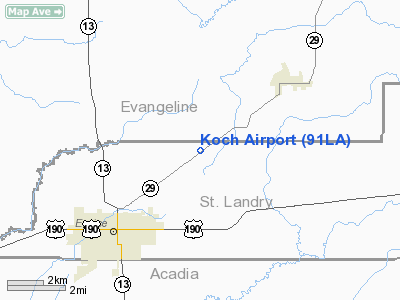
Location &
QuickFacts
|
FAA
Information Effective: |
2008-09-25 |
|
Airport
Identifier: |
91LA |
|
Airport
Status: |
Operational |
|
Longitude/Latitude: |
092-22-02.4690W/30-32-04.7160N
-92.367352/30.534643 (Estimated) |
|
Elevation: |
51 ft / 15.54 m (Estimated) |
|
Land: |
5 acres |
|
From
nearest city: |
3 nautical miles NE of Eunice, LA |
|
Location: |
St Landry Parish, LA |
|
Magnetic Variation: |
04E (1985) |
Owner & Manager
|
Ownership: |
Privately owned |
|
Owner: |
Danny Koch |
|
Address: |
175 Rougeau Rd.
Eunice, LA 70535-2732 |
|
Phone number: |
337-457-7008 |
|
Manager: |
Danny Koch |
|
Address: |
175 Rougeau Rd.
Eunice, LA 70535-2732 |
|
Phone number: |
337-457-7008 |
Airport
Operations and Facilities
|
Airport
Use: |
Private |
|
Wind
indicator: |
Yes |
|
Segmented Circle: |
No |
|
Control
Tower: |
No |
|
Sectional chart: |
Houston |
|
Region: |
ASW - Southwest |
|
Boundary
ARTCC: |
ZHU - Houston |
|
Tie-in
FSS: |
DRI - De Ridder |
|
FSS Toll
Free: |
1-800-WX-BRIEF |
|
Runway Information
Runway 05/23
|
Dimension: |
2480 x 75 ft / 755.9 x 22.9 m |
|
Surface: |
TURF, |
|
|
Runway 05
|
Runway 23
|
|
Traffic
Pattern: |
Left |
Left |
|
Radio Navigation Aids
|
ID |
Type |
Name |
Ch |
Freq |
Var |
Dist |
|
POE |
FAN MARKER |
South |
|
|
07E |
49.0 nm |
|
ECY |
NDB |
Eunice |
|
263.00 |
02E |
4.4 nm |
|
OPL |
NDB |
St Landry |
|
335.00 |
04E |
15.7 nm |
|
LRR |
NDB |
Allen Parish |
|
379.00 |
03E |
17.8 nm |
|
BWK |
NDB |
Bunkie |
|
397.00 |
03E |
21.0 nm |
|
MKV |
NDB |
Marksville |
|
347.00 |
02E |
37.0 nm |
|
AR |
NDB |
Acadi |
|
269.00 |
03E |
43.5 nm |
|
HZ |
NDB |
Hazer |
|
356.00 |
04E |
45.8 nm |
|
LFT |
VORTAC |
Lafayette |
035X |
109.80 |
03E |
28.2 nm |
|
AEX |
VORTAC |
Alexandria |
108X |
116.10 |
03E |
43.9 nm |
|
LCH |
VORTAC |
Lake Charles |
081X |
113.40 |
07E |
45.0 nm |
Based Aircraft
|
Aircraft based
on field: |
2 |
|
Single Engine
Airplanes: |
1 |
|
Ultralights: |
1
ULTRALIGHT ACTIVITY ON & INVOF ARPT. |
Koch Airport
Address:
St Landry Parish, LA
Tel:
337-457-7008
Images
and information placed above are from
http://www.airport-data.com/airport/91LA/
We
thank them for the data!
|
General Info |
| Country |
United
States |
| State |
LOUISIANA |
| FAA ID |
91LA
|
| Latitude |
30-32-04.716N |
|
Longitude |
092-22-02.469W |
|
Elevation |
51 feet
|
| Near
City |
EUNICE
|
We don't guarantee the information is fresh and accurate. The data may
be wrong or outdated.
For more up-to-date information please refer to other sources.
|
|


