 |
|
|
|
|
|
Location &
QuickFacts
|
FAA
Information Effective: |
2008-09-25 |
|
Airport
Identifier: |
LS83 |
|
Airport
Status: |
Operational |
|
Longitude/Latitude: |
091-15-15.4060W/32-03-45.5570N
-91.254279/32.062655 (Estimated) |
|
Elevation: |
77 ft / 23.47 m (Estimated) |
|
Land: |
20 acres |
|
From
nearest city: |
1 nautical miles SW of Newellton, LA |
|
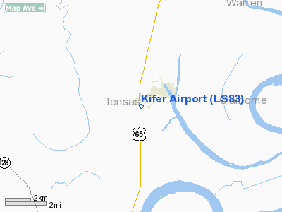
Location: |
Tensas Parish, LA |
|
Magnetic Variation: |
03E (1985) |
Owner & Manager
|
Ownership: |
Publicly owned |
|
Owner: |
City Of Newellton |
|
Address: |
Po Box 477
Newellton, LA 71357 |
|
Phone number: |
318-467-5050 |
|
Manager: |
Sonny Kifer |
|
Address: |
Po Box 177
Newellton, LA 71357 |
|
Phone number: |
318-467-5212
OR 318-467-5245. |
Airport
Operations and Facilities
|
Airport
Use: |
Private |
|
Wind
indicator: |
Yes |
|
Segmented Circle: |
No |
|
Control
Tower: |
No |
|
Lighting
Schedule: |
DUSK-DAWN |
|
Beacon
Color: |
Clear-Green (lighted land airport)
ROTG BCN OTS INDEFLY. |
|
Landing fee charge: |
No |
|
Sectional chart: |
Memphis |
|
Region: |
ASW - Southwest |
|
Boundary ARTCC: |
ZME - Memphis |
|
Tie-in FSS: |
DRI - De Ridder |
|
FSS on Airport: |
No |
|
FSS Toll Free: |
1-800-WX-BRIEF |
Airport Services
|
Airframe
Repair: |
NONE |
|
Power
Plant Repair: |
NONE |
|
Bottled
Oxygen: |
NONE |
|
Bulk
Oxygen: |
NONE |
|
Runway Information
Runway 06/24
|
Dimension: |
2750 x 75 ft / 838.2 x 22.9 m |
|
Surface: |
ASPH, Poor Condition
FIRST 1545 FT SW HAS SEVERE ALLIGATOR CRACKING; POTHOLES; GRASS ENCROACHMENT
& FOREIGN OBJECT DEBRIS. |
|
Surface
Treatment: |
Aggregate Friction Seal Coat |
|
Weight Limit: |
Single wheel: 5000 lbs. |
|
Edge Lights: |
Medium
MIRL OTS INDEFLY. |
|
|
Runway 06
|
Runway 24
|
|
Traffic
Pattern: |
Left |
Left |
|
Markings: |
Basic, Poor Condition |
Basic, Good Condition |
|
Obstruction: |
19 ft road, 200.0 ft from runway
HWY 200' FM THR & RD PARALLEL TO RWY ON S. |
40 ft pline, 790.0 ft from runway, 75 ft left of
centerline, 14:1 slope to clear
RD PARALLEL TO RY ON S; RD 60 FT FM THLD; RD 121 FT FM RY END; PLINE 175
FT FM THLD; EQUIP 100 FT FM END OF RY. |
|
Radio Navigation Aids
|
ID |
Type |
Name |
Ch |
Freq |
Var |
Dist |
|
TV |
NDB |
Savry |
|
344.00 |
02E |
16.0 nm |
|
VKS |
NDB |
Vicksburg |
|
382.00 |
03E |
19.6 nm |
|
HAH |
NDB |
Natchez-adams County |
|
388.00 |
03E |
22.5 nm |
|
MRK |
NDB |
Molly Ridge |
|
338.00 |
02E |
33.5 nm |
|
RYB |
NDB |
Raymond |
|
375.00 |
03E |
45.2 nm |
|
BLE |
NDB |
Lake Providence |
|
278.00 |
03E |
46.3 nm |
|
HEZ |
VOR/DME |
Natchez |
037X |
110.00 |
03E |
26.8 nm |
|
MLU |
VORTAC |
Monroe |
119X |
117.20 |
03E |
48.2 nm |
Remarks
-
APRON AREA & TWY
EDGES HAVE EXCESSIVE TURF BUILDUP WITH POSSIBLE PONDING.
-
CULTIVATED FIELDS
95 FT NW OF RY.
-
PRE-DATES ACT.
Based Aircraft
|
Aircraft based
on field: |
8 |
|
Single Engine
Airplanes: |
8 |
Operational Statistics
Time Period: 1999-08-17 - 2000-08-15
|
Aircraft
Operations: |
135/Week |
|
General
Aviation Local: |
71.4% |
|
General
Aviation Itinerant: |
28.6% |
Kifer Airport
Address:
Tensas Parish, LA
Tel:
318-467-5050, 318-467-5212, 318-467-5245
Images
and information placed above are from
http://www.airport-data.com/airport/LS83/
We
thank them for the data!
|
|


