 |
|
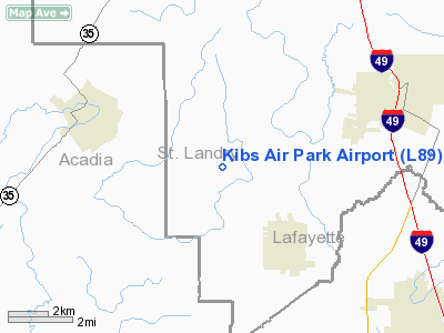
Location &
QuickFacts
|
FAA
Information Effective: |
2008-09-25 |
|
Airport
Identifier: |
L89 |
|
Airport
Status: |
Operational |
|
Longitude/Latitude: |
092-08-45.4440W/30-22-52.7180N
-92.145957/30.381311 (Estimated) |
|
Elevation: |
51 ft / 15.54 m (Estimated) |
|
Land: |
15 acres |
|
From
nearest city: |
3 nautical miles SE of Bristol, LA |
|
Location: |
St Landry Parish, LA |
|
Magnetic Variation: |
04E (1990) |
Owner & Manager
|
Ownership: |
Privately owned |
|
Owner: |
Jackie Joseph Kibodeaux |
|
Address: |
434 Bearb Rd
Sunset, LA 70584 |
|
Phone number: |
337-684-5419 |
|
Manager: |
Jackie Joseph Kibodeaux |
|
Address: |
434 Bearb Rd
Sunset, LA 70584 |
|
Phone number: |
337-684-5419 |
Airport
Operations and Facilities
|
Airport
Use: |
Open to public |
|
Wind
indicator: |
Yes |
|
Segmented Circle: |
No |
|
Control
Tower: |
No |
|
Sectional chart: |
Houston |
|
Region: |
ASW - Southwest |
|
Boundary
ARTCC: |
ZHU - Houston |
|
Tie-in
FSS: |
DRI - De Ridder |
|
FSS on
Airport: |
No |
|
FSS Toll
Free: |
1-800-WX-BRIEF |
|
NOTAMs
Facility: |
DRI (NOTAM-d service avaliable) |
Airport Communications
Airport Services
|
Runway Information
Runway 09/27
|
Dimension: |
2640 x 80 ft / 804.7 x 24.4 m |
|
Surface: |
TURF, Good Condition |
|
|
Runway 09
|
Runway 27
|
|
Traffic
Pattern: |
Left |
Left |
|
Displaced
threshold: |
250.00 ft
DSPLCD THLD MARKED WITH ORANGE CONES. |
0.00 ft |
|
Obstruction: |
15 ft road, 50.0 ft from runway, 3:1 slope to clear
APCH SLOPE 20:1 TO DSPLCD THLD. |
60 ft trees, 1500.0 ft from runway, 25:1 slope to clear |
|
Radio Navigation Aids
|
ID |
Type |
Name |
Ch |
Freq |
Var |
Dist |
|
OPL |
NDB |
St Landry |
|
335.00 |
04E |
16.7 nm |
|
ECY |
NDB |
Eunice |
|
263.00 |
02E |
19.0 nm |
|
BWK |
NDB |
Bunkie |
|
397.00 |
03E |
29.5 nm |
|
AR |
NDB |
Acadi |
|
269.00 |
03E |
29.5 nm |
|
LRR |
NDB |
Allen Parish |
|
379.00 |
03E |
32.2 nm |
|
HZ |
NDB |
Hazer |
|
356.00 |
04E |
37.2 nm |
|
MKV |
NDB |
Marksville |
|
347.00 |
02E |
43.1 nm |
|
LLA |
VOR/DME |
White Lake |
041X |
110.40 |
04E |
44.8 nm |
|
LFT |
VORTAC |
Lafayette |
035X |
109.80 |
03E |
13.8 nm |
|
BTR |
VORTAC |
Baton Rouge |
112X |
116.50 |
06E |
44.6 nm |
Remarks
-
PRVDD THE THRS
ARE LCTD TO PROVIDE 20:1 CLEARANCE OVER OBSTRUCTIONS.
Based Aircraft
|
Aircraft based
on field: |
2 |
|
Single Engine
Airplanes: |
2 |
Operational Statistics
Time Period: 2007-06-26 - 2008-06-24
|
Aircraft
Operations: |
25/Week |
|
General
Aviation Local: |
76.9% |
|
General
Aviation Itinerant: |
23.1% |
Kibs Air Park Airport
Address:
St Landry Parish, LA
Tel:
337-684-5419
Images
and information placed above are from
http://www.airport-data.com/airport/L89/
We
thank them for the data!
|
General Info |
| Country |
United
States |
| State |
LOUISIANA |
| FAA ID |
L89
|
| Latitude |
30-22-52.718N |
|
Longitude |
092-08-45.444W |
|
Elevation |
51 feet
|
| Near
City |
BRISTOL
|
We don't guarantee the information is fresh and accurate. The data may
be wrong or outdated.
For more up-to-date information please refer to other sources.
|
|


