 |
|
|
|
|
|
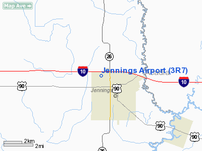
Location &
QuickFacts
|
FAA
Information Effective: |
2008-09-25 |
|
Airport
Identifier: |
3R7 |
|
Airport
Status: |
Operational |
|
Longitude/Latitude: |
092-40-24.5974W/30-14-33.7165N
-92.673499/30.242699 (Estimated) |
|
Elevation: |
23 ft / 7.01 m (Surveyed) |
|
Land: |
325 acres |
|
From
nearest city: |
1 nautical miles NW of Jennings, LA |
|
Location: |
Jefferson Davis Parish, LA |
|
Magnetic Variation: |
02E (2005) |
Owner & Manager
|
Ownership: |
Publicly owned |
|
Owner: |
Jefferson Davis Parish |
|
Address: |
Arpt Commission Dist Nr 1, P. O. Box 745
Jennings, LA 70546 |
|
Phone number: |
337-824-1567 |
|
Manager: |
Ed Krielow |
|
Address: |
Box 598
Jennings, LA 70546 |
|
Phone number: |
318-616-2370 |
Airport
Operations and Facilities
|
Airport
Use: |
Open to public |
|
Wind
indicator: |
Yes |
|
Segmented Circle: |
No |
|
Control
Tower: |
No |
|
Lighting
Schedule: |
DUSK-DAWN
MIRL RYS 08/26 & 13/31, REIL RYS 13 & 31 PRESET LOW INTST; TO INCR
INTST ACTVT - CTAF. |
|
Beacon
Color: |
Clear-Green (lighted land airport) |
|
Landing
fee charge: |
No |
|
Sectional chart: |
Houston |
|
Region: |
ASW - Southwest |
|
Boundary
ARTCC: |
ZHU - Houston |
|
Tie-in
FSS: |
DRI - De Ridder |
|
FSS on
Airport: |
No |
|
FSS Toll
Free: |
1-800-WX-BRIEF |
|
NOTAMs
Facility: |
DRI (NOTAM-d service avaliable) |
|
Federal Agreements: |
NGY |
Airport Communications
|
CTAF: |
122.800 |
|
Unicom: |
122.800 |
Airport Services
|
Fuel
available: |
100LLA
SELF SERVICE FUEL AVBL AFT HRS WITH CREDIT CARD. |
|
Bottled
Oxygen: |
NONE |
|
Bulk
Oxygen: |
NONE |
|
Runway Information
Runway 08/26
|
Dimension: |
5002 x 75 ft / 1524.6 x 22.9 m |
|
Surface: |
ASPH, Good Condition |
|
Weight Limit: |
Single wheel: 12000 lbs. |
|
Edge Lights: |
Medium |
|
|
Runway 08
|
Runway 26
|
|
Longitude: |
092-41-08.4610W |
092-40-12.4261W |
|
Latitude: |
30-14-32.6426N |
30-14-41.8042N |
|
Elevation: |
17.00 ft |
20.00 ft |
|
Alignment: |
79 |
127 |
|
Traffic
Pattern: |
Left |
Right |
|
Markings: |
Non-precision instrument, Good Condition |
Non-precision instrument, Good Condition |
|
Obstruction: |
30 ft trees, 1200.0 ft from runway, 105 ft left of
centerline, 34:1 slope to clear |
25 ft pole, 850.0 ft from runway, 120 ft right of
centerline, 26:1 slope to clear |
|
Runway 13/31
|
Dimension: |
3601 x 75 ft / 1097.6 x 22.9 m |
|
Surface: |
ASPH, Good Condition |
|
Weight Limit: |
Single wheel: 12000 lbs. |
|
Edge Lights: |
Medium |
|
|
Runway 13
|
Runway 31
|
|
Longitude: |
092-40-28.2897W |
092-39-59.2614W |
|
Latitude: |
30-14-41.7078N |
30-14-16.4990N |
|
Elevation: |
18.00 ft |
23.00 ft |
|
Alignment: |
127 |
127 |
|
Traffic
Pattern: |
Right |
Left |
|
Markings: |
Basic, Fair Condition
MARKINGS SLIGHTLY FADED. |
Basic, Fair Condition
MARKINGS SLIGHTLY FADED. |
|
Crossing
Height: |
50.00 ft |
50.00 ft |
|
Displaced
threshold: |
0.00 ft |
588.00 ft |
|
VASI: |
2-light PAPI on left side |
2-light PAPI on left side |
|
Visual
Glide Angle: |
3.00° |
3.00° |
|
Runway End
Identifier: |
Yes |
Yes |
|
Obstruction: |
, 50:1 slope to clear |
35 ft trees, 570.0 ft from runway, 125 ft right of
centerline, 10:1 slope to clear
APCH RATIO 27:1 FM DSPLCD THLD.
5 FT FENCE & +15 FT ROAD 140 FT FM END OF RY. |
|
Runway 17/35
|
Dimension: |
1977 x 150 ft / 602.6 x 45.7 m |
|
Surface: |
TURF, Good Condition |
|
|
Runway 17
|
Runway 35
|
|
Longitude: |
092-40-04.1522W |
092-40-04.2804W |
|
Latitude: |
30-14-43.0283N |
30-14-23.4638N |
|
Elevation: |
22.00 ft |
22.00 ft |
|
Alignment: |
127 |
0 |
|
Traffic
Pattern: |
Right |
Left |
|
Obstruction: |
30 ft pole, 500.0 ft from runway, 75 ft right of
centerline, 16:1 slope to clear |
40 ft pline, 1200.0 ft from runway, 30:1 slope to clear |
|
Radio Navigation Aids
|
ID |
Type |
Name |
Ch |
Freq |
Var |
Dist |
|
ECY |
NDB |
Eunice |
|
263.00 |
02E |
22.4 nm |
|
LRR |
NDB |
Allen Parish |
|
379.00 |
03E |
24.0 nm |
|
OPL |
NDB |
St Landry |
|
335.00 |
04E |
38.8 nm |
|
UX |
NDB |
Sulfy |
|
278.00 |
04E |
38.9 nm |
|
DQU |
NDB |
De Quincy |
|
410.00 |
05E |
42.8 nm |
|
BWK |
NDB |
Bunkie |
|
397.00 |
03E |
43.8 nm |
|
AR |
NDB |
Acadi |
|
269.00 |
03E |
45.5 nm |
|
DR |
NDB |
Idder |
|
385.00 |
04E |
45.9 nm |
|
LLA |
VOR/DME |
White Lake |
041X |
110.40 |
04E |
38.2 nm |
|
LCH |
VORTAC |
Lake Charles |
081X |
113.40 |
07E |
23.3 nm |
|
LFT |
VORTAC |
Lafayette |
035X |
109.80 |
03E |
35.5 nm |
Remarks
-
20 FT UNLGTD TWR
150 FT FM AER 35.
-
ULTRALIGHT ACTIVITY INVOF ARPT.
-
NUMEROUS
AGRICULTURAL ACFT INVOF ARPT.
Based Aircraft
|
Aircraft based
on field: |
48 |
|
Single Engine
Airplanes: |
34 |
|
Multi Engine
Airplanes: |
8 |
|
Ultralights: |
6 |
Operational Statistics
Time Period: 2006-09-21 - 2007-09-20
|
Aircraft
Operations: |
146/Day |
|
General
Aviation Local: |
65.0% |
|
General
Aviation Itinerant: |
30.2% |
|
Military: |
4.8% |
Jennings Airport
Address:
Jefferson Davis Parish, LA
Tel:
337-824-1567, 318-616-2370
Images
and information placed above are from
http://www.airport-data.com/airport/3R7/
We
thank them for the data!
|
General Info |
| Country |
United
States |
| State |
LOUISIANA |
| FAA ID |
3R7
|
| Latitude |
30-14-33.696N |
|
Longitude |
092-40-24.412W |
|
Elevation |
23 feet
|
| Near
City |
JENNINGS
|
We don't guarantee the information is fresh and accurate. The data may
be wrong or outdated.
For more up-to-date information please refer to other sources.
|
|


