|
|
|
 |
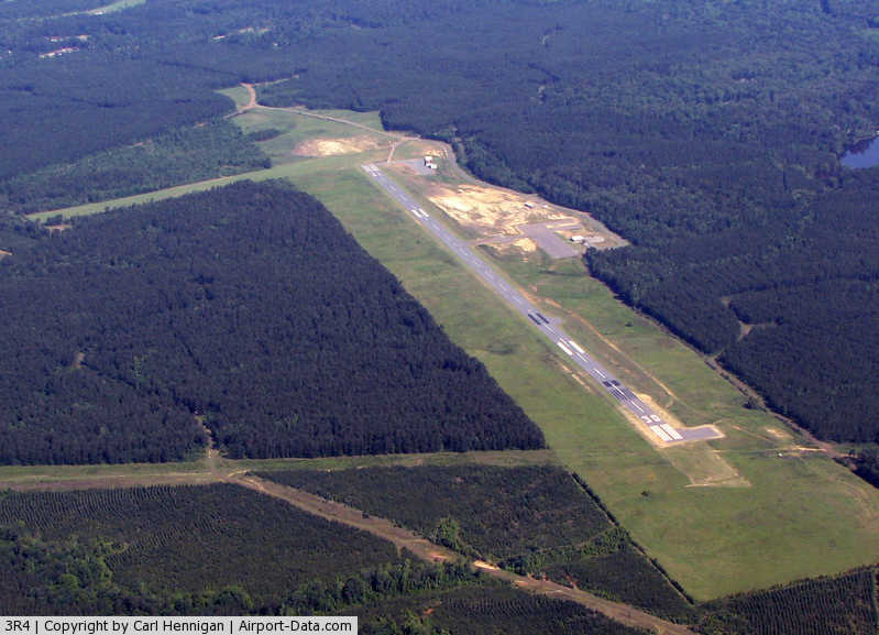
(Click on the photo to enlarge) |
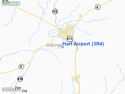
Location &
QuickFacts
|
FAA
Information Effective: |
2008-09-25 |
|
Airport
Identifier: |
3R4 |
|
Airport
Status: |
Operational |
|
Longitude/Latitude: |
093-29-09.3019W/31-32-40.7692N
-93.485917/31.544658 (Estimated) |
|
Elevation: |
319 ft / 97.23 m (Surveyed) |
|
Land: |
250 acres |
|
From
nearest city: |
2 nautical miles SW of Many, LA |
|
Location: |
Sabine Parish, LA |
|
Magnetic Variation: |
04E (1990) |
Owner & Manager
|
Ownership: |
Publicly owned |
|
Owner: |
City Of Many |
|
Address: |
Po Box 1330
Many, LA 71449 |
|
Phone number: |
318-256-3651 |
|
Manager: |
Lee Woods |
|
Address: |
950 Airport Rd
Many, LA 71449 |
|
Phone number: |
318-256-5857 |
Airport
Operations and Facilities
|
Airport
Use: |
Open to public |
|
Wind
indicator: |
Yes |
|
Segmented Circle: |
No |
|
Control
Tower: |
No |
|
Lighting
Schedule: |
DUSK-DAWN
ACTVT MIRL RY 12/30 & REIL RY 12 - CTAF. |
|
Beacon
Color: |
Clear-Green (lighted land airport)
ROTG BCN OTS INDEFLY. |
|
Landing
fee charge: |
No |
|
Sectional chart: |
Houston |
|
Region: |
ASW - Southwest |
|
Boundary
ARTCC: |
ZHU - Houston |
|
Tie-in
FSS: |
DRI - De Ridder |
|
FSS on
Airport: |
No |
|
FSS Toll
Free: |
1-800-WX-BRIEF |
|
NOTAMs
Facility: |
DRI (NOTAM-d service avaliable) |
|
Federal Agreements: |
NGY |
Airport Communications
|
CTAF: |
122.800 |
|
Unicom: |
122.800 |
Airport Services
|
Fuel
available: |
100LL
SELF SERVICE FUEL AVBL AFT HRS WITH CREDIT CARD. |
|
Airframe
Repair: |
NONE |
|
Power
Plant Repair: |
NONE |
|
Bottled
Oxygen: |
NONE |
|
Bulk
Oxygen: |
NONE |
|
Runway Information
Runway 01/19
|
Dimension: |
1822 x 75 ft / 555.3 x 22.9 m |
|
Surface: |
TURF, Poor Condition |
|
|
Runway 01
|
Runway 19
|
|
Longitude: |
093-29-32.1320W |
093-29-23.6310W |
|
Latitude: |
31-32-36.1280N |
31-32-52.6280N |
|
Alignment: |
24 |
127 |
|
Traffic
Pattern: |
Left |
Left |
|
Obstruction: |
15 ft trees |
28 ft trees, 405.0 ft from runway, 14:1 slope to clear |
|
Runway 12/30
|
Dimension: |
4402 x 75 ft / 1341.7 x 22.9 m |
|
Surface: |
ASPH, Fair Condition |
|
Weight Limit: |
Single wheel: 6000 lbs. |
|
Edge Lights: |
Medium |
|
|
Runway 12
|
Runway 30
|
|
Longitude: |
093-29-23.5043W |
093-28-39.9048W |
|
Latitude: |
31-32-50.5090N |
31-32-28.0780N |
|
Elevation: |
318.00 ft |
307.00 ft |
|
Alignment: |
121 |
127 |
|
Traffic
Pattern: |
Left |
Left |
|
Markings: |
Non-precision instrument, Fair Condition |
Non-precision instrument, Good Condition
MARKINGS FADED. |
|
Crossing
Height: |
26.00 ft |
26.00 ft |
|
VASI: |
2-box SAVASI on left side |
2-box SAVASI on left side |
|
Visual
Glide Angle: |
4.00° |
4.00° |
|
Runway End
Identifier: |
Yes
REIL OTS INDEFLY. |
|
|
Obstruction: |
40 ft trees, 1200.0 ft from runway, 25:1 slope to clear |
80 ft trees, 2200.0 ft from runway, 200 ft right of
centerline, 25:1 slope to clear |
|
Radio Navigation Aids
|
ID |
Type |
Name |
Ch |
Freq |
Var |
Dist |
|
POE1 |
FAN MARKER |
North |
|
|
07E |
29.4 nm |
|
POE |
FAN MARKER |
South |
|
|
07E |
37.8 nm |
|
MMY |
NDB |
Many |
|
272.00 |
04E |
3.3 nm |
|
IE |
NDB |
Campi |
|
407.00 |
04E |
22.0 nm |
|
VED |
NDB |
Leesville |
|
247.00 |
04E |
27.6 nm |
|
MSD |
NDB |
Mansfield |
|
414.00 |
04E |
34.3 nm |
|
GUV |
NDB |
Gator |
|
359.00 |
05E |
34.7 nm |
|
CZJ |
NDB |
Amason |
|
341.00 |
04E |
38.3 nm |
|
JAS |
NDB |
Jasper |
|
344.00 |
04E |
45.3 nm |
|
DR |
NDB |
Idder |
|
385.00 |
04E |
48.3 nm |
|
IFJ |
NDB |
Winnfield |
|
402.00 |
04E |
49.3 nm |
|
SWB |
VOR/DME |
Sawmill |
84Y |
113.75 |
02E |
48.7 nm |
|
FXU |
VORTAC |
Polk |
021X |
108.40 |
05E |
29.4 nm |
Remarks
-
WIND SOCK
INDICATOR LGT OTS INDEFLY.
-
GCO AVBL ON FREQ
135.075 THRU POE APCH AND DRI AFSS.
-
PRE-DATES ACT.
Based Aircraft
|
Aircraft based
on field: |
4 |
|
Single Engine
Airplanes: |
2 |
|
Ultralights: |
2 |
Operational Statistics
Time Period: 2007-07-11 - 2008-07-09
|
Aircraft
Operations: |
99/Week |
|
General
Aviation Local: |
39.2% |
|
General
Aviation Itinerant: |
58.8% |
|
Military: |
2.0% |
Hart Airport
Address:
Sabine Parish, LA
Tel:
318-256-3651, 318-256-5857
Images
and information placed above are from
http://www.airport-data.com/airport/3R4/
We
thank them for the data!
|
General Info |
| Country |
United
States |
| State |
LOUISIANA |
| FAA ID |
3R4
|
| Latitude |
31-32-41.628N |
|
Longitude |
093-29-11.231W |
|
Elevation |
324 feet
|
| Near
City |
MANY
|
We don't guarantee the information is fresh and accurate. The data may
be wrong or outdated.
For more up-to-date information please refer to other sources.
|
|