 |
|
Harry P Williams Memorial Airport |
| Harry P. Williams Memorial Airport |
 |
| IATA: PTN â ICAO: KPTN â FAA LID: PTN |
| Summary |
| Airport type |
Public |
| Owner |
State of Louisiana |
| Operator |
Mr. Ken Parry |
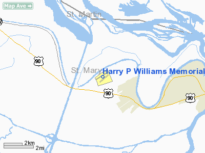
| Serves |
Patterson, Louisiana |
| Location |
Patterson, LA |
| Elevation AMSL |
9 ft / 3 m |
| Coordinates |
29°42â²34â³N 091°20â²20â³W / 29.70944°N 91.33889°W / 29.70944; -91.33889 (Harry P. Williams Memorial Airport)Coordinates: 29°42â²34â³N 091°20â²20â³W / 29.70944°N 91.33889°W / 29.70944; -91.33889 (Harry P. Williams Memorial Airport) |
| Runways |
| Direction |
Length |
Surface |
| ft |
m |
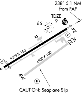
| 6/24 |
5,399 |
1,646 |
Asphalt |
| 4W/22W |
4,500 |
1,372 |
Water |
| Statistics (June 2008) |
| Aircraft located at the Airport |
27 |
| Source: Federal Aviation Administration |
Harry P. Williams Memorial Airport (IATA: PTN, ICAO: KPTN, FAA LID: PTN) is a public airport in Patterson, Louisiana. It has two runways, one of them being water. Facilities
Available services include 100LL Fuel, Jet Fuel, as well as major airframe and powerplant service.
Terminal procedures (Instrument Approach Procedures)
- ILS RWY 24
- GPS RWY 6
- GPS RWY 24
- VOR/DME-A
- NDB RWY 6
The above content comes from Wikipedia and is published under free licenses – click here to read more.
Location &
QuickFacts
|
FAA
Information Effective: |
2008-09-25 |
|
Airport
Identifier: |
PTN |
|
Airport
Status: |
Operational |
|
Longitude/Latitude: |
091-20-20.3230W/29-42-34.3670N
-91.338979/29.709546 (Estimated) |
|
Elevation: |
9 ft / 2.74 m (Surveyed) |
|
Land: |
488 acres |
|
From
nearest city: |
2 nautical miles NW of Patterson, LA |
|
Location: |
St Mary Parish, LA |
|
Magnetic Variation: |
01E (2005) |
Owner & Manager
|
Ownership: |
Publicly owned |
|
Owner: |
State Of Louisiana |
|
Address: |
Dept Of Public Works
Baton Rouge, LA 70821 |
|
Phone
number: |
225-342-7954 |
|
Manager: |
Mr. Ken Perry |
|
Address: |
P. O. Box 85
Patterson, LA 70392 |
|
Phone number: |
985-395-4501 |
Airport Operations and Facilities
|
Airport
Use: |
Open to public |
|
Wind
indicator: |
Yes |
|
Segmented Circle: |
Yes |
|
Control
Tower: |
No |
|
Lighting
Schedule: |
DUSK-DAWN
MIRL RY 06/24 PRESET LOW INTST; TO INCR INTST & ACTVT REIL RY 06 &
MALSR RY 24 - CTAF. |
|
Beacon
Color: |
Clear-Green (lighted land airport) |
|
Landing
fee charge: |
No |
|
Sectional chart: |
Houston |
|
Region: |
ASW - Southwest |
|
Boundary
ARTCC: |
ZHU - Houston |
|
Tie-in
FSS: |
DRI - De Ridder |
|
FSS on
Airport: |
No |
|
FSS Toll
Free: |
1-800-WX-BRIEF |
|
NOTAMs
Facility: |
PTN (NOTAM-d service avaliable) |
|
Federal Agreements: |
NGY |
Airport Communications
|
CTAF: |
122.800 |
|
Unicom: |
122.800 |
Airport Services
|
Fuel
available: |
100LLA |
|
Airframe
Repair: |
MAJOR |
|
Power
Plant Repair: |
MAJOR |
|
Bottled
Oxygen: |
NONE |
|
Bulk
Oxygen: |
NONE |
|
Runway Information
Runway 04W/22W
|
Dimension: |
4500 x 100 ft / 1371.6 x 30.5 m |
|
Surface: |
WATER,
3 INCH LIP (DROPOFF) SOUTH SIDE OF RY. |
|
|
Runway 04W |
Runway 22W |
|
Longitude: |
091-20-37.9090W |
091-19-56.3830W |
|
Latitude: |
29-42-15.9230N |
29-42-41.7480N |
|
Alignment: |
55 |
127 |
|
Traffic
Pattern: |
Right |
Left |
|
Obstruction: |
20 ft road, 600.0 ft from runway, 30:1 slope to clear |
28 ft trees, 200.0 ft from runway, 125 ft left of
centerline, 7:1 slope to clear |
|
Runway 06/24
|
Dimension: |
5399 x 150 ft / 1645.6 x 45.7 m |
|
Surface: |
ASPH, Good Condition
3 INCH LIP (DROPOFF) SOUTH SIDE OF RY. |
|
Weight Limit: |
Single wheel: 32000 lbs. |
|
Edge Lights: |
Medium |
|
|
Runway 06 |
Runway 24 |
|
Longitude: |
091-20-49.2318W |
091-19-56.6989W |
|
Latitude: |
29-42-25.2262N |
29-42-52.6667N |
|
Elevation: |
7.00 ft |
8.00 ft |
|
Alignment: |
59 |
127 |
|
ILS Type: |
|
ILS/DME |
|
Traffic
Pattern: |
Left |
Right |
|
Markings: |
Non-precision instrument, Fair Condition |
Precision instrument, Fair Condition |
|
Crossing
Height: |
50.00 ft |
50.00 ft |
|
Displaced
threshold: |
394.00 ft |
0.00 ft |
|
VASI: |
2-light PAPI on left side |
2-light PAPI on left side |
|
Visual
Glide Angle: |
3.00° |
3.00° |
|
Approach
lights: |
|
MALSR |
|
Runway End
Identifier: |
Yes |
No |
|
Obstruction: |
44 ft trees, 1100.0 ft from runway, 200 ft left of
centerline, 20:1 slope to clear
APCH RATIO 29:1 TO DSPLCD THLD. |
, 50:1 slope to clear |
|
Radio Navigation Aids
|
ID |
Type |
Name |
Ch |
Freq |
Var |
Dist |
|
PTN |
NDB |
Patterson |
|
245.00 |
01E |
0.3 nm |
|
AR |
NDB |
Acadi |
|
269.00 |
03E |
31.1 nm |
|
RQR |
VOR/DME |
Reserve |
045X |
110.80 |
02E |
45.2 nm |
|
TBD |
VORTAC |
Tibby |
057X |
112.00 |
02E |
26.8 nm |
|
LFT |
VORTAC |
Lafayette |
035X |
109.80 |
03E |
44.8 nm |
|
BTR |
VORTAC |
Baton Rouge |
112X |
116.50 |
06E |
46.7 nm |
Remarks
-
FIRE HYDRANT LCTD
NEAR RY 22W THLD.
-
4500 FT BY 100 FT
WATERWAY HDG 04/22 LCTD 1100 FT SOUTH OF CONC RY.
DUAL LAND/SEA OPERATION.
Based Aircraft
|
Aircraft based
on field: |
27 |
|
Single Engine
Airplanes: |
10 |
|
Multi Engine
Airplanes: |
2 |
|
Helicopters: |
14 |
|
Ultralights: |
1 |
Operational Statistics
Time Period: 2007-06-28 - 2008-06-26
|
Aircraft
Operations: |
277/Day |
|
General
Aviation Local: |
59.6% |
|
General
Aviation Itinerant: |
40.4% |
|
Military: |
0.1% |
Harry P Williams Memorial Airport
Address:
St Mary Parish, LA
Tel:
225-342-7954,
985-395-4501
Images
and information placed above are from
http://www.airport-data.com/airport/PTN/
We
thank them for the data!
|
General Info |
| Country |
United
States |
| State |
LOUISIANA |
| FAA ID |
PTN
|
| Latitude |
29-42-39.000N |
|
Longitude |
091-20-23.000W |
|
Elevation |
9 feet
|
| Near
City |
PATTERSON |
We don't guarantee the information is fresh and accurate. The data may
be wrong or outdated.
For more up-to-date information please refer to other sources.
|
|


