 |
|
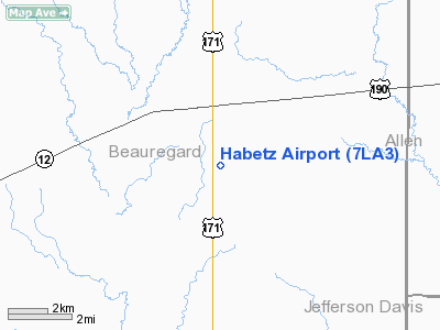
Location &
QuickFacts
|
FAA
Information Effective: |
2008-09-25 |
|
Airport
Identifier: |
7LA3 |
|
Airport
Status: |
Operational |
|
Longitude/Latitude: |
093-13-43.5700W/30-28-58.7180N
-93.228769/30.482977 (Estimated) |
|
Elevation: |
79 ft / 24.08 m (Estimated) |
|
Land: |
0 acres |
|
From
nearest city: |
10 nautical miles NE of Ragley, LA |
|
Location: |
Beauregard Parish, LA |
|
Magnetic Variation: |
05E (1985) |
Owner & Manager
|
Ownership: |
Privately owned |
|
Address: |
|
|
Manager: |
P. J. Habetz |
|
Address: |
15713 Hwy 171
Ragley, LA 70657 |
|
Phone number: |
318-725-3332 |
Airport Operations and Facilities
|
Airport Use: |
Private |
|
Wind indicator: |
Yes |
|
Segmented Circle: |
No |
|
Control Tower: |
No |
|
Landing fee charge: |
No |
|
Sectional chart: |
Houston |
|
Region: |
ASW - Southwest |
|
Boundary ARTCC: |
ZHU - Houston |
|
Tie-in FSS: |
DRI - De Ridder |
|
FSS on Airport: |
No |
|
FSS Toll Free: |
1-800-WX-BRIEF |
Airport Services
|
Airframe
Repair: |
NONE |
|
Power
Plant Repair: |
NONE |
|
Runway Information
Runway 01/19
|
Dimension: |
3100 x 50 ft / 944.9 x 15.2 m |
|
Surface: |
TURF, |
|
|
Runway 01
|
Runway 19
|
|
Traffic
Pattern: |
Left |
Left |
|
Radio Navigation Aids
|
ID |
Type |
Name |
Ch |
Freq |
Var |
Dist |
|
POE |
FAN MARKER |
South |
|
|
07E |
30.0 nm |
|
POE1 |
FAN MARKER |
North |
|
|
07E |
37.8 nm |
|
DQU |
NDB |
De Quincy |
|
410.00 |
05E |
12.7 nm |
|
DR |
NDB |
Idder |
|
385.00 |
04E |
17.1 nm |
|
UX |
NDB |
Sulfy |
|
278.00 |
04E |
19.8 nm |
|
LRR |
NDB |
Allen Parish |
|
379.00 |
03E |
29.5 nm |
|
GUV |
NDB |
Gator |
|
359.00 |
05E |
32.9 nm |
|
VED |
NDB |
Leesville |
|
247.00 |
04E |
37.7 nm |
|
ORG |
NDB |
Orange |
|
211.00 |
05E |
38.5 nm |
|
ECY |
NDB |
Eunice |
|
263.00 |
02E |
40.7 nm |
|
LCH |
VORTAC |
Lake Charles |
081X |
113.40 |
07E |
21.5 nm |
|
FXU |
VORTAC |
Polk |
021X |
108.40 |
05E |
37.8 nm |
Habetz Airport
Address:
Beauregard Parish, LA
Tel:
318-725-3332
Images
and information placed above are from
http://www.airport-data.com/airport/7LA3/
We
thank them for the data!
|
General Info |
| Country |
United
States |
| State |
LOUISIANA |
| FAA ID |
7LA3
|
| Latitude |
30-28-58.718N |
|
Longitude |
093-13-43.570W |
|
Elevation |
79 feet
|
| Near
City |
RAGLEY
|
We don't guarantee the information is fresh and accurate. The data may
be wrong or outdated.
For more up-to-date information please refer to other sources.
|
|


