|
 |
|
||||
|
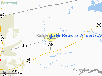
Esler Airfield (IATA: ESF, ICAO: KESF, FAA LID: ESF) is a Louisiana Army National Guard Airfield with limited public use and is located 10 nautical miles (19 km) northeast of the central business district of Alexandria, a city in Rapides Parish, Louisiana, United States. It is owned by the Louisiana National Guard and is the home of Army Aviation Support Facility #2 (AASF#2). The airfield has no scheduled commercial airline service. HistoryWorld War IIAfter World War I in 1919 the Army had abandoned Camp Beauregard and turned the property over to the state of Louisiana, which returned it to the United States, however interest in the military utilization of Camp Beauregard increased significantly in 1939 when war began in Europe. The United States needed a training ground for American troops. In 1940 the land was returned to the War Department for use as a World War II training area. That area included the now-abandoned Camps Claiborne and Livingston and what has become Esler Regional Airport. Construction of the airport, originally called Camp Beauregard Army Field, for the United States Army Air Corps began in 1940. In the summer of 1940 and throughout 1941 the area was used for the "Louisiana Maneuvers". and the Air Corps used the airfield extensively during the maneuvers, with the 67th Observation Group stationing the 107th Observation Squadron at the airfield between 28 October 1940 and 14 December 1941. In addition, the 109th Observation Squadron used the airport from 27 February 1941 until 18 December 1942 flying light observation planes. The airfield was renamed Esler Army Airfield in 1941 to honor Lt. Wyler Esler, a pilot who became the first casualty of the airfield when his plane crashed on April 11, 1941. Esler AAF was assigned to Third Air Force, III Air Support Command. The 333d Air Base Group was the host unit at the airfield, being activated on 1 February 1942. The first unit assigned for training at Esler was the 12th Bombardment Group, arriving for B-25 Mitchell training on 21 February 1942. The unit remained at Esler until July until being deployed to the Middle East and being assigned to Ninth Air Force. In December 1942, the mission was changed to training Reconnaissance units, and Esler was reassigned directly to Third Air Force. The 347th Army Air Force Base Unit became the host unit at the station. Reconnaissance groups receiving training at the airfield were:
In late 1943, Esler was again reassigned within Third Air Force, to the I Tactical Air Division, to become a close air support training field. The Division moved its headquarters to the field in April 1944. The P-40 Warhawk-equipped 372d Fighter Group trained at Esler in March and April 1944. With the departure of the 372d, the 353d Army Air Force Base Unit took over training for replacement pilots, and unit training ended. On 20 April 1945, the 353d BU was redesignated as the 353d AAF BU (Maneuver Station), and Esler supported various training maneuvers at Fort Polk, providing simulated tactical air support to Army units. On 1 August 1945, the airfield was again reassigned directly to Third Air Force. With the end of the war, inactivation of Esler Field began on 7 September 1945. However, the Air Force's inactivation was quite slow, with the airfield being put on standby status 31 January 1946. The 353d was redesignated as a Standby Unit, but not inactivated, keeping a skeleton force of 6 officers and 50 civilians assigned to the base until 31 May 1946 when the base was finally closed. The airfield remained Federal property until the 1950s when it was finally ceded to the Police Jury as surplus property, A small civilian airport opened after return to civil control.
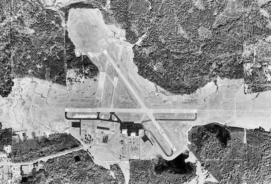
Recent historyIn the early '90s, Esler Regional Airport became lifeless and quiet with an uncertain future after airport services for Central Louisiana were moved to the England Industrial Airpark and Community, the location of the defunct England Air Force Base. But the abandoned Esler presented the Louisiana National Guard with a golden opportunity to expand the area available to conduct its training. On June 1, 2001, the Rapides Parish Police Jury transferred the airport's management to the Guard in a 99-year lease. Today, Esler is the site of numerous training exercises. But Esler goes beyond military activities. While about 60 percent of the airport's operations are military, the rest are civilian. Although Esler doesn't offer private jet passenger services it does provide both military and civilian aircraft fuel services through its civilian contractor Million Air Interlink Inc. While Alexandria International Airport is Central Louisiana's primary airport and the leader of aviation services in the area, Esler is the area's secondary airport. The airport's runways can handle the heavy weight of most airline traffic, such as 137-passenger-capacity Boeing 737s, 224-passenger-capacity Boeing 757s and the C-17 Globemasters that are the primary cargo plane of the Air Force and weigh 169,000 pounds each. Facilities and aircraftEsler Regional Airport covers an area of 2,161 acres (875 ha) at an elevation of 112 feet (34 m) above mean sea level. It has two asphalt paved runways: 8/26 is 5,999 by 150 feet (1,828 x 46 m) and 14/32 is 5,601 by 150 feet (1,707 x 46 m). For the 12-month period ending March 26, 2009, the airport had 8,300 aircraft operations, an average of 22 per day: 77% general aviation and 23% military. At that time there were 27 aircraft based at this airport: 44% single-engine, 4% jet and 52% military. The above content comes from Wikipedia and is published under free licenses – click here to read more.
Runway InformationRunway 08/26
Runway 14/32
Radio Navigation Aids
Remarks
Based Aircraft
Operational StatisticsTime Period: 2007-03-22 - 2008-03-20
Esler Regional Airport Address: Rapides Parish, LA Tel: 318-767-2536 Images
and information placed above are from We thank them for the data!
We don't guarantee the information is fresh and accurate. The data may
be wrong or outdated.
|
|||||||||||||||||||||||||||||||||||||||||||||||||||||||||||||||||||||||||||||||||||||||||||||||||||||||||||||||||||||||||||||||||||||||||||||||||||||||||||||||||||||||||||||||||||||||||||||||||||||||||||||||||||||||||||||||||||||||||||||||||||||||||||||||||||||||||||||||||||||||||||||||||||||||||||||||||||||||||||||||||||||||||||||||||||||||||||||||||||||||||||||||||||||||||||||

 |
|
Copyright 2004-2026 © by Airports-Worldwide.com, Vyshenskoho st. 36, Lviv 79010, Ukraine Legal Disclaimer |