 |
|
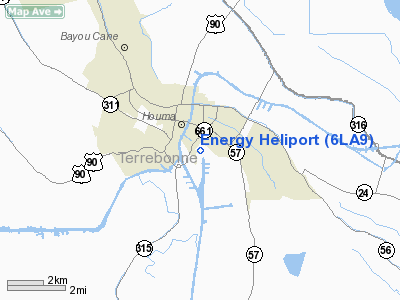
Location &
QuickFacts
|
FAA
Information Effective: |
2008-09-25 |
|
Airport
Identifier: |
6LA9 |
|
Airport
Status: |
Operational |
|
Longitude/Latitude: |
090-42-20.3240W/29-34-30.7720N
-90.705646/29.575214 (Estimated) |
|
Elevation: |
13 ft / 3.96 m (Estimated) |
|
Land: |
5 acres |
|
From
nearest city: |
3 nautical miles E of Houma, LA |
|
Location: |
Terrebonne Parish, LA |
|
Magnetic Variation: |
03E (1985) |
Owner & Manager
|
Ownership: |
Privately owned |
|
Owner: |
Energy Helicopters, Inc. |
|
Address: |
550 South Van Ave
Houma, LA 70361 |
|
Phone
number: |
504-868-1050 |
|
Manager: |
T. L. Duhe & Lynn Goucher |
|
Address: |
401 Glynn Ave
Houma, LA 70361 |
|
Phone number: |
504-876-0080 |
Airport
Operations and Facilities
|
Airport
Use: |
Private |
|
Wind
indicator: |
Yes |
|
Segmented Circle: |
No |
|
Control
Tower: |
No |
|
Sectional chart: |
New Orleans |
|
Region: |
ASW - Southwest |
|
Boundary
ARTCC: |
ZHU - Houston |
|
Tie-in
FSS: |
DRI - De Ridder |
|
FSS on
Airport: |
No |
|
FSS Toll
Free: |
1-800-WX-BRIEF |
|
Runway Information
Helipad H1
|
Dimension: |
20 x 20 ft / 6.1 x 6.1 m
APCH/DEP WITHIN AN ARC FROM SE THRU WEST. |
|
Surface: |
CONC, |
|
|
Runway H1
|
Runway
|
|
Traffic
Pattern: |
Left |
Left |
|
Radio Navigation Aids
|
ID |
Type |
Name |
Ch |
Freq |
Var |
Dist |
|
MS |
NDB |
Kinte |
|
338.00 |
03E |
31.4 nm |
|
PTN |
NDB |
Patterson |
|
245.00 |
01E |
34.0 nm |
|
RQR |
VOR/DME |
Reserve |
045X |
110.80 |
02E |
31.4 nm |
|
TBD |
VORTAC |
Tibby |
057X |
112.00 |
02E |
8.4 nm |
|
LEV |
VORTAC |
Leeville |
082X |
113.50 |
02E |
39.6 nm |
|
HRV |
VORTAC |
Harvey |
088X |
114.10 |
02E |
40.2 nm |
|
NEW |
VOT |
New Orleans Lakefront |
|
111.00 |
|
45.1 nm |
Based Aircraft
|
Aircraft based
on field: |
5 |
|
Helicopters: |
5 |
Energy Heliport
Address:
Terrebonne Parish, LA
Tel:
504-868-1050,
504-876-0080
Images
and information placed above are from
http://www.airport-data.com/airport/6LA9/
We
thank them for the data!
|
General Info |
| Country |
United
States |
| State |
LOUISIANA |
| FAA ID |
6LA9
|
| Latitude |
29-34-30.772N |
|
Longitude |
090-42-20.324W |
|
Elevation |
13 feet
|
| Near
City |
HOUMA
|
We don't guarantee the information is fresh and accurate. The data may
be wrong or outdated.
For more up-to-date information please refer to other sources.
|
|


