 |
|
|
|
|
|
Location &
QuickFacts
|
FAA
Information Effective: |
2008-09-25 |
|
Airport
Identifier: |
F86 |
|
Airport
Status: |
Operational |
|
Longitude/Latitude: |
092-03-16.2000W/32-07-19.8000N
-92.054500/32.122167 (Estimated) |
|
Elevation: |
67 ft / 20.42 m (Surveyed) |
|
Land: |
70 acres |
|
From
nearest city: |
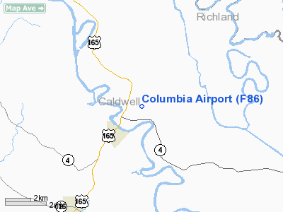
2 nautical miles NE of Columbia, LA |
|
Location: |
Caldwell Parish, LA |
|
Magnetic Variation: |
04E (1985) |
Owner & Manager
|
Ownership: |
Publicly owned |
|
Owner: |
Caldwell Parish Police Jury |
|
Address: |
Po Box 1737
Columbia, LA 71418 |
|
Phone number: |
318-649-2681 |
|
Manager: |
Charlie Brown |
|
Address: |
Po Box 120
Grayson, LA 71435 |
|
Phone number: |
318-649-5997 |
Airport
Operations and Facilities
|
Airport
Use: |
Open to public |
|
Wind
indicator: |
Yes |
|
Segmented Circle: |
No |
|
Control
Tower: |
No |
|
Lighting
Schedule: |
DUSK-DAWN |
|
Beacon
Color: |
Clear-Green (lighted land airport) |
|
Landing
fee charge: |
No |
|
Sectional chart: |
Memphis |
|
Region: |
ASW - Southwest |
|
Boundary
ARTCC: |
ZHU - Houston |
|
Responsible ARTCC: |
ZFW - Fort Worth |
|
Tie-in
FSS: |
DRI - De Ridder |
|
FSS on
Airport: |
No |
|
FSS Toll
Free: |
1-800-WX-BRIEF |
|
NOTAMs
Facility: |
DRI (NOTAM-d service avaliable) |
|
Federal Agreements: |
S |
Airport Communications
Airport Services
|
Airframe
Repair: |
NONE |
|
Power
Plant Repair: |
NONE |
|
Bottled
Oxygen: |
NONE |
|
Bulk
Oxygen: |
NONE |
|
Runway Information
Runway 01/19
|
Dimension: |
3501 x 75 ft / 1067.1 x 22.9 m |
|
Surface: |
ASPH, Good Condition |
|
Weight Limit: |
Single wheel: 6000 lbs. |
|
Edge Lights: |
Medium |
|
|
Runway 01
|
Runway 19
|
|
Longitude: |
092-03-20.6548W |
092-03-11.8033W |
|
Latitude: |
32-07-02.8517N |
32-07-36.6654N |
|
Elevation: |
67.00 ft |
63.00 ft |
|
Alignment: |
13 |
127 |
|
Traffic
Pattern: |
Left |
Left |
|
Markings: |
Basic, Good Condition |
Basic, Good Condition |
|
Crossing
Height: |
20.00 ft |
20.00 ft |
|
VASI: |
2-box SAVASI on left side
SAVASI OTS INDEFLY. |
2-box SAVASI on left side
SAVASI OTS INDEFLY. |
|
Visual
Glide Angle: |
4.00° |
4.00° |
|
Obstruction: |
65 ft trees, 1500.0 ft from runway, 82 ft right of
centerline, 20:1 slope to clear
4 FT FENCE 197 FT FM END OF RY. |
35 ft trees, 1400.0 ft from runway, 34:1 slope to clear |
|
Radio Navigation Aids
|
ID |
Type |
Name |
Ch |
Freq |
Var |
Dist |
|
MRK |
NDB |
Molly Ridge |
|
338.00 |
02E |
22.3 nm |
|
IFJ |
NDB |
Winnfield |
|
402.00 |
04E |
32.2 nm |
|
TUF |
NDB |
Stuckey |
|
350.00 |
03E |
32.2 nm |
|
JBL |
NDB |
Hodge |
|
256.00 |
04E |
34.5 nm |
|
BQP |
NDB |
Bastrop |
|
329.00 |
03E |
39.0 nm |
|
ROQ |
NDB |
Ruston |
|
368.00 |
03E |
39.9 nm |
|
HAH |
NDB |
Natchez-adams County |
|
388.00 |
03E |
46.7 nm |
|
SWB |
VOR/DME |
Sawmill |
84Y |
113.75 |
02E |
33.0 nm |
|
HEZ |
VOR/DME |
Natchez |
037X |
110.00 |
03E |
49.0 nm |
|
MLU |
VORTAC |
Monroe |
119X |
117.20 |
03E |
23.7 nm |
Remarks
-
RY 19 DRAINAGE
DITCH 110 FT END OF RY & 8 FT DEEP STARTING ABOUT 120 FT BOTH SIDES OF CNTRLN.
Based Aircraft
|
Aircraft based
on field: |
12 |
|
Single Engine
Airplanes: |
12 |
Operational Statistics
Time Period: 2006-08-30 - 2007-08-29
|
Aircraft
Operations: |
265/Week |
|
General
Aviation Local: |
72.7% |
|
General
Aviation Itinerant: |
27.3% |
Columbia Airport
Address:
Caldwell Parish, LA
Tel:
318-649-2681, 318-649-5997
Images
and information placed above are from
http://www.airport-data.com/airport/F86/
We
thank them for the data!
|
General Info |
| Country |
United
States |
| State |
LOUISIANA |
| FAA ID |
F86
|
| Latitude |
32-07-20.561N |
|
Longitude |
092-03-10.483W |
|
Elevation |
66 feet
|
| Near
City |
COLUMBIA
|
We don't guarantee the information is fresh and accurate. The data may
be wrong or outdated.
For more up-to-date information please refer to other sources.
|
|


