|
|
Chennault International Airport |
| Chennault International Airport |
 |
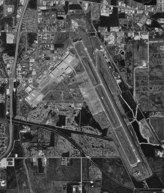
| USGS aerial photo as of 23 January 1994 |
| IATA: CWF â ICAO: KCWF â FAA LID: CWF |
| Summary |
| Airport type |
Public |
| Owner |
Chennault International Airport Authority |
| Serves |
Lake Charles, Louisiana |
| Elevation AMSL |
17 ft / 5 m |
| Coordinates |
30°12â²38â³N 093°08â²35â³W / 30.21056°N 93.14306°W / 30.21056; -93.14306 |
| Runways |
| Direction |
Length |
Surface |
| ft |
m |
| 15/33 |
10,701 |
3,262 |
Concrete |
| Statistics (2006) |
| Aircraft operations |
52,976 |
| Based aircraft |
42 |
| Sources: airport website and FAA |
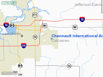
Chennault International Airport (IATA: CWF, ICAO: KCWF, FAA LID: CWF) is a public use airport located four nautical miles (7 km) east of the central business district of Lake Charles, a city in Calcasieu Parish, Louisiana, United States. It is owned by the Chennault International Airport Authority.
It was previously Chennault Air Force Base and before that, Lake Charles Air Force Base, and as such, was home to the now deactivated 44th Bomb Wing in the 1950s and 1960s.
While a fully operational airport, it is an industrial center and provides no commercial air services. It is named for Major General Claire Chennault, USAAF, the aviator famous for commanding the Flying Tigers fighter group during World War II.
Its mission statement reads as follows: "The Authority created pursuant hereto shall be established for the primary object and purpose of stimulating and encouraging the development of an industrial park for economic development through commerce, industry and research and for the utilization and development of natural and human resources of the area and provide job opportunities."
Northrop Grumman Corporation is Chennault's major aircraft manufacturing and modification tenant. Aeroframe Services, LLC (formerly EADS Aeroframe Services, Inc.) specializes in maintenance and overhaul services for Airbus. The Chennault Jet Center, the focus of Chennault's Fixed Base Operations for business and general aviation, as well as charter operations, is also located nearby. Airborne Express air freight operations serve Southwest Louisiana and Southeast Texas with daily DC-9 jet service from its on-airport truck hub, providing tenants with immediate access to express air shipping. Other features
Sowela Technical Community College, located on the former Chennault Air Force Base, offers a variety of academic and technical programs with terminating certificates, diplomas, and/or associate degrees. The College's Workforce Development unit tailors training programs to meet local business, industry and community training needs.
The site is also officially designated by NASA as an alternative landing site for the Space Shuttle.
The Mallard Cove Golf Course, an 18-hole championship golf course, is located near the airport.
Facilities and aircraft
Chennault International Airport covers an area of 1,310 acres (530 ha) at an elevation of 17 feet (5 m) above mean sea level. It has one concrete paved runway designated 15/33 which measures 10,701 by 200 feet (3,262 by 61 m).
For the 12-month period ending December 31, 2006, the airport had 52,976 aircraft operations, an average of 145 per day: 58% general aviation, 38% military, 3% air taxi and 1% scheduled commercial. At that time there were 42 aircraft based at this airport: 38% single-engine, 10% multi-engine, 29% jet, 12% helicopter and 12% military.
The above content comes from Wikipedia and is published under free licenses – click here to read more.
Location &
QuickFacts
|
FAA
Information Effective: |
2008-09-25 |
|
Airport
Identifier: |
CWF |
|
Airport
Status: |
Operational |
|
Longitude/Latitude: |
093-08-35.4820W/30-12-38.1300N
-93.143189/30.210592 (Estimated) |
|
Elevation: |
17 ft / 5.18 m (Surveyed) |
|
Land: |
1310 acres |
|
From
nearest city: |
4 nautical miles E of Lake Charles, LA |
|
Location: |
Calcasieu Parish, LA |
|
Magnetic Variation: |
04E (1990) |
Owner & Manager
|
Ownership: |
Publicly owned |
|
Owner: |
Chennault Intl Arpt Authority |
|
Address: |
3650 Sen. J. Bennett Johnston Ave
Lake Charles, LA 70615-6849 |
|
Phone
number: |
337-491-9961 |
|
Manager: |
Charles M. Harvey
DEPUTY DIRECTOR. |
|
Address: |
3650 Sen. J. Bennett Johnston Ave
Lake Charles, LA 70615-6849 |
|
Phone number: |
337-491-9961 |
Airport Operations and Facilities
|
Airport
Use: |
Open to public |
|
Wind
indicator: |
Yes |
|
Segmented Circle: |
Yes |
|
Control
Tower: |
Yes |
|
Lighting
Schedule: |
DUSK-DAWN
WHEN ATCT CLSD ACTVT HIRL RY 15/33; MALSR RY 15 & REIL RY 33 - CTAF. |
|
Beacon
Color: |
Clear-Green (lighted land airport) |
|
Landing
fee charge: |
No |
|
Sectional chart: |
Houston |
|
Region: |
ASW - Southwest |
|
Traffic
Pattern Alt: |
1483 ft |
|
Boundary
ARTCC: |
ZHU - Houston |
|
Tie-in
FSS: |
DRI - De Ridder |
|
FSS on
Airport: |
No |
|
FSS Toll
Free: |
1-800-WX-BRIEF |
|
NOTAMs
Facility: |
CWF (NOTAM-d service avaliable) |
|
Certification type/date: |
IV A U 07/199
6 HRS PPR FOR ACR OPNS WITH MORE THAN 30 PSGR SEATS CALL AMGR
337-491-9961. |
|
Federal Agreements: |
N |
Airport Communications
|
CTAF: |
124.200 |
|
Unicom: |
122.950 |
Airport Services
|
Fuel
available: |
100LLA1+
FOR FUEL CALL 337-436-4877. |
|
Bottled
Oxygen: |
LOW |
|
Bulk
Oxygen: |
NONE |
|
Runway Information
Runway 15/33
|
Dimension: |
10701 x 200 ft / 3261.7 x 61.0 m |
|
Surface: |
CONC, Fair Condition |
|
Weight Limit: |
Single wheel: 75000 lbs.
Dual wheel: 200000 lbs.
Dual tandem wheel: 320000 lbs.
Dual dual tandem wheel: 750000 lbs. |
|
Edge Lights: |
High |
|
|
Runway 15
|
Runway 33
|
|
Longitude: |
093-09-01.7970W |
093-08-09.1670W |
|
Latitude: |
30-13-25.9060N |
30-11-50.3540N |
|
Elevation: |
15.00 ft |
17.00 ft |
|
Alignment: |
127 |
127 |
|
ILS Type: |
ILS |
|
|
Traffic
Pattern: |
Left |
Right |
|
Markings: |
Precision instrument, Fair Condition |
Precision instrument, Fair Condition |
|
Crossing
Height: |
53.00 ft |
53.00 ft |
|
VASI: |
4-light PAPI on left side |
4-light PAPI on left side |
|
Visual
Glide Angle: |
3.00° |
3.00° |
|
Approach
lights: |
MALSR |
|
|
Runway End
Identifier: |
No |
Yes |
|
Decleard
distances: |
Take off run available 10701.00 ft
Take off distance available 10701.00 ft
Actual stop distance available 10701.00 ft
Landing distance available 10701.00 ft |
Take off run available 10701.00 ft
Take off distance available 10701.00 ft
Actual stop distance available 10701.00 ft
Landing distance available 10701.00 ft |
|
Radio Navigation Aids
|
ID |
Type |
Name |
Ch |
Freq |
Var |
Dist |
|
POE |
FAN MARKER |
South |
|
|
07E |
46.2 nm |
|
UX |
NDB |
Sulfy |
|
278.00 |
04E |
14.4 nm |
|
DQU |
NDB |
De Quincy |
|
410.00 |
05E |
21.6 nm |
|
DR |
NDB |
Idder |
|
385.00 |
04E |
34.0 nm |
|
ORG |
NDB |
Orange |
|
211.00 |
05E |
34.9 nm |
|
LRR |
NDB |
Allen Parish |
|
379.00 |
03E |
35.0 nm |
|
ECY |
NDB |
Eunice |
|
263.00 |
02E |
41.7 nm |
|
GUV |
NDB |
Gator |
|
359.00 |
05E |
49.2 nm |
|
BPT |
VOR/DME |
Beaumont |
092X |
114.50 |
07E |
48.1 nm |
|
LCH |
VORTAC |
Lake Charles |
081X |
113.40 |
07E |
4.6 nm |
Remarks
-
INDEX E AVBL WITH
24 HRS NOTICE CALL AMGR 337-491-9961.
-
BIRDS ON & INVOF OF ARPT
-
OCNL HEAVY JET
ACFT ON & INVOF ARPT.
-
TFC PATTERN 600'
& BLO. PRVDD ATCT OPNL TO PRVD ATC SVCS PRIOR TO ACFT OPNS.
Based Aircraft
|
Aircraft based
on field: |
39 |
|
Single Engine
Airplanes: |
17 |
|
Multi Engine
Airplanes: |
6 |
|
Jet Engine
Airplanes: |
10 |
|
Military: |
6 |
Operational Statistics
Time Period: 2007-01-01 - 2007-12-31
|
Aircraft
Operations: |
150/Day |
|
Commerical: |
0.6% |
|
Air Taxi: |
2.9% |
|
General
Aviation Local: |
24.0% |
|
General
Aviation Itinerant: |
35.4% |
|
Military: |
37.1% |
Chennault International Airport
Address:
Calcasieu Parish, LA
Tel:
337-491-9961
Images
and information placed above are from
http://www.airport-data.com/airport/CWF/
We
thank them for the data!
|
General Info |
| Country |
United
States |
| State |
LOUISIANA |
| FAA ID |
CWF
|
| Latitude |
30-12-38.130N |
|
Longitude |
093-08-35.482W |
|
Elevation |
17 feet
|
| Near
City |
LAKE
CHARLES |
We don't guarantee the information is fresh and accurate. The data may
be wrong or outdated.
For more up-to-date information please refer to other sources.
|
|