 |
|
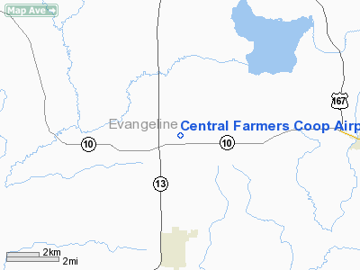
Central Farmers Coop Airport |
|
|
Location &
QuickFacts
|
FAA
Information Effective: |
2008-09-25 |
|
Airport
Identifier: |
LA25 |
|
Airport
Status: |
Closed Indefinitely |
|
Longitude/Latitude: |
092-24-50.4770W/30-41-50.7090N
-92.414021/30.697419 (Estimated) |
|
Elevation: |
68 ft / 20.73 m (Surveyed) |
|
Land: |
36 acres |
|
From
nearest city: |
3 nautical miles N of Mamou, LA |
|
Location: |
Evangeline Parish, LA |
|
Magnetic Variation: |
04E (1985) |
Owner & Manager
|
Ownership: |
Privately owned |
|
Owner: |
Central Farmers Coop |
|
Address: |
1082 Airport Road
Mamou, LA 70554 |
|
Phone
number: |
318-468-3175 |
|
Manager: |
J. C. Landreau |
|
Address: |
1082 Airport Road
Ville Platte, LA 70586 |
|
Phone number: |
318-363-5636 |
Airport Operations and Facilities
|
Airport
Use: |
Private |
|
Wind
indicator: |
Yes |
|
Segmented Circle: |
No |
|
Control
Tower: |
No |
|
Lighting
Schedule: |
DUSK-DAWN |
|
Beacon
Color: |
Clear-Green (lighted land airport)
ROTG BCN OTS INDEFLY. |
|
Landing fee charge: |
No |
|
Sectional chart: |
Houston |
|
Region: |
ASW - Southwest |
|
Boundary ARTCC: |
ZHU - Houston |
|
Tie-in FSS: |
DRI - De Ridder |
|
FSS on Airport: |
No |
|
FSS Toll Free: |
1-800-WX-BRIEF |
Airport Services
|
Runway Information
Runway 18/36
|
Dimension: |
3000 x 70 ft / 914.4 x 21.3 m |
|
Surface: |
ASPH, Poor Condition
HAS SEVERAL POTHOLES ON CNTRLN OF RY; SEVERE CRACKING. |
|
Weight Limit: |
Single wheel: 5000 lbs. |
|
|
Runway 18
|
Runway 36
|
|
Traffic
Pattern: |
Left |
Left |
|
Markings: |
Basic, Fair Condition |
Nonstandard, Fair Condition
BASIC MARKINGS; DSPLCD THLD PAINTED YELLOW. |
|
Displaced
threshold: |
0.00 ft |
600.00 ft |
|
Obstruction: |
45 ft trees, 1100.0 ft from runway, 125 ft left of
centerline, 20:1 slope to clear |
30 ft bldg, 265.0 ft from runway, 30 ft right of
centerline, 2:1 slope to clear
APCH RATIO 28:1 FM DSPLCD THR.
ROAD AND BLDG AT THR RWY 36. |
|
Radio Navigation Aids
|
ID |
Type |
Name |
Ch |
Freq |
Var |
Dist |
|
POE |
FAN MARKER |
South |
|
|
07E |
42.2 nm |
|
POE1 |
FAN MARKER |
North |
|
|
07E |
48.4 nm |
|
ECY |
NDB |
Eunice |
|
263.00 |
02E |
8.5 nm |
|
BWK |
NDB |
Bunkie |
|
397.00 |
03E |
13.7 nm |
|
LRR |
NDB |
Allen Parish |
|
379.00 |
03E |
14.6 nm |
|
OPL |
NDB |
St Landry |
|
335.00 |
04E |
16.5 nm |
|
MKV |
NDB |
Marksville |
|
347.00 |
02E |
29.7 nm |
|
GUV |
NDB |
Gator |
|
359.00 |
05E |
44.5 nm |
|
DR |
NDB |
Idder |
|
385.00 |
04E |
47.7 nm |
|
HZ |
NDB |
Hazer |
|
356.00 |
04E |
48.0 nm |
|
AEX |
VORTAC |
Alexandria |
108X |
116.10 |
03E |
33.9 nm |
|
LFT |
VORTAC |
Lafayette |
035X |
109.80 |
03E |
37.3 nm |
|
FXU |
VORTAC |
Polk |
021X |
108.40 |
05E |
48.4 nm |
|
LCH |
VORTAC |
Lake Charles |
081X |
113.40 |
07E |
49.0 nm |
Remarks
-
BE ALERT FOR FARM
EQUIPMENT ON END OF RY 36.
-
(ARPT STATUS)
ARPT CLSD INDEFLY.
Based Aircraft
|
Aircraft based
on field: |
2 |
|
Single Engine
Airplanes: |
2 |
Operational Statistics
Time Period: 1996-02-08 - 1997-02-06
|
Aircraft
Operations: |
37/Week |
|
General
Aviation Local: |
78.9% |
|
General
Aviation Itinerant: |
21.1% |
Central Farmers Coop Airport
Address:
Evangeline Parish, LA
Tel:
318-468-3175,
318-363-5636
Images
and information placed above are from
http://www.airport-data.com/airport/LA25/
We
thank them for the data!
|
General Info |
| Country |
United
States |
| State |
LOUISIANA |
| FAA ID |
LA25
|
| Latitude |
30-41-50.709N |
|
Longitude |
092-24-50.477W |
|
Elevation |
68 feet
|
| Near
City |
MAMOU
|
We don't guarantee the information is fresh and accurate. The data may
be wrong or outdated.
For more up-to-date information please refer to other sources.
|
|


