 |
|
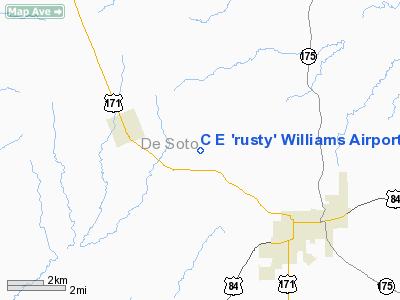
C E 'rusty' Williams Airport |
|
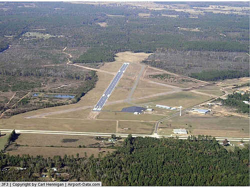 |
(Click on the photo to enlarge) |
Location &
QuickFacts
|
FAA
Information Effective: |
2008-09-25 |
|
Airport
Identifier: |
3F3 |
|
Airport
Status: |
Operational |
|
Longitude/Latitude: |
093-45-55.8680W/32-04-24.4550N
-93.765519/32.073460 (Estimated) |
|
Elevation: |
324 ft / 98.76 m (Surveyed) |
|
Land: |
1044 acres |
|
From
nearest city: |
3 nautical miles NW of Mansfield, LA |
|
Location: |
De Soto Parish, LA |
|
Magnetic Variation: |
04E (1990) |
Owner & Manager
|
Ownership: |
Publicly owned |
|
Owner: |
De Soto Parish Police Jury |
|
Address: |
Po Box 898
Mansfield, LA 71052 |
|
Phone number: |
318-872-0738 |
|
Manager: |
Rick Grimsley |
|
Address: |
Po Box 816
Mansfield, LA 71052 |
|
Phone number: |
318-871-8900 |
Airport
Operations and Facilities
|
Airport
Use: |
Open to public |
|
Wind
indicator: |
Yes |
|
Segmented Circle: |
Yes |
|
Control
Tower: |
No |
|
Lighting
Schedule: |
DUSK-DAWN
MIRL RY 18/36 PRESET LOW INTST; TO INCR INTST & ACTVT REIL RYS 18 & 36
- CTAF. |
|
Beacon
Color: |
Clear-Green (lighted land airport) |
|
Landing
fee charge: |
No |
|
Sectional chart: |
Memphis |
|
Region: |
ASW - Southwest |
|
Boundary
ARTCC: |
ZFW - Fort Worth |
|
Tie-in
FSS: |
DRI - De Ridder |
|
FSS on
Airport: |
No |
|
FSS Toll
Free: |
1-800-WX-BRIEF |
|
NOTAMs
Facility: |
DRI (NOTAM-d service avaliable) |
|
Federal Agreements: |
NGY3 |
Airport Communications
|
CTAF: |
122.800 |
|
Unicom: |
122.800 |
Airport Services
|
Fuel
available: |
100LLA |
|
Airframe
Repair: |
MAJOR |
|
Power
Plant Repair: |
MAJOR |
|
Bottled
Oxygen: |
NONE |
|
Bulk
Oxygen: |
NONE |
|
Runway Information
Runway 18/36
|
Dimension: |
4500 x 100 ft / 1371.6 x 30.5 m |
|
Surface: |
ASPH, Good Condition |
|
Weight Limit: |
Single wheel: 12000 lbs. |
|
Edge Lights: |
Medium |
|
|
Runway 18
|
Runway 36
|
|
Longitude: |
093-45-53.2460W |
093-45-58.4890W |
|
Latitude: |
32-04-46.6050N |
32-04-02.2990N |
|
Elevation: |
317.00 ft |
324.00 ft |
|
Alignment: |
127 |
6 |
|
Traffic
Pattern: |
Left |
Left |
|
Markings: |
Non-precision instrument, Good Condition |
Non-precision instrument, Good Condition |
|
Crossing
Height: |
50.00 ft |
58.00 ft |
|
VASI: |
2-light PAPI on left side |
2-light PAPI on left side |
|
Visual
Glide Angle: |
3.00° |
3.50° |
|
Runway End
Identifier: |
Yes |
Yes |
|
Obstruction: |
30 ft trees, 1200.0 ft from runway, 33:1 slope to clear |
80 ft trees, 3000.0 ft from runway, 36:1 slope to clear |
|
Radio Navigation Aids
|
ID |
Type |
Name |
Ch |
Freq |
Var |
Dist |
|
MSD |
NDB |
Mansfield |
|
414.00 |
04E |
0.6 nm |
|
CZJ |
NDB |
Amason |
|
341.00 |
04E |
24.5 nm |
|
RPF |
NDB |
Carthage |
|
332.00 |
04E |
27.8 nm |
|
MMY |
NDB |
Many |
|
272.00 |
04E |
32.3 nm |
|
MNE |
NDB |
Minden |
|
201.00 |
04E |
41.4 nm |
|
IE |
NDB |
Campi |
|
407.00 |
04E |
43.1 nm |
|
VIV |
NDB |
Vivian |
|
284.00 |
06E |
48.9 nm |
|
BAD |
TACAN |
Barksdale |
105X |
|
05E |
26.3 nm |
|
DTN |
VOR |
Downtown |
|
108.60 |
07E |
28.1 nm |
|
EMG |
VORTAC |
Elm Grove |
049X |
111.20 |
07E |
21.5 nm |
|
EIC |
VORTAC |
Belcher |
121X |
117.40 |
07E |
42.0 nm |
|
SHV |
VOT |
Shreveport Regional |
|
108.20 |
|
32.7 nm |
Based Aircraft
|
Aircraft based
on field: |
10 |
|
Single Engine
Airplanes: |
9 |
|
Multi Engine
Airplanes: |
1 |
Operational Statistics
Time Period: 2006-08-02 - 2007-08-01
|
Aircraft
Operations: |
179/Week |
|
General
Aviation Local: |
43.0% |
|
General
Aviation Itinerant: |
53.8% |
|
Military: |
3.2% |
C E 'rusty' Williams Airport
Address:
De Soto Parish, LA
Tel:
318-872-0738, 318-871-8900
Images
and information placed above are from
http://www.airport-data.com/airport/3F3/
We
thank them for the data!
|
General Info |
| Country |
United
States |
| State |
LOUISIANA |
| FAA ID |
3F3
|
| Latitude |
32.073460
32° 04' 24.46" N |
|
Longitude |
-93.765518
093° 45' 55.86" W |
|
Elevation |
324 feet
99 meters |
| Type |
Civil
|
| Magnetic
Variation |
002° E
(01/06) |
| Beacon |
Yes
|
|
Operating Agency |
MUNICIPAL |
| Daylight
Saving Time |
Second
Sunday in March at 0200 to first Sunday in November at 0200 local time
(Exception Arizona and that portion of Indiana in the Eastern Time
Zone) |
We don't guarantee the information is fresh and accurate. The data may
be wrong or outdated.
For more up-to-date information please refer to other sources.
|
|


