 |
|
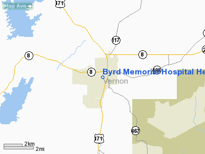
Byrd Memorial Hospital Heliport |
|
|
Location &
QuickFacts
|
FAA
Information Effective: |
2008-09-25 |
|
Airport
Identifier: |
LA29 |
|
Airport
Status: |
Operational |
|
Longitude/Latitude: |
093-16-08.5930W/31-08-15.6710N
-93.269054/31.137686 (Estimated) |
|
Elevation: |
250 ft / 76.20 m (Estimated) |
|
Land: |
0 acres |
|
From
nearest city: |
0 nautical miles SW of Leesville, LA |
|
Location: |
Vernon Parish, LA |
|
Magnetic Variation: |
05E (1985) |
Owner & Manager
|
Ownership: |
Privately owned
MEDICAL TRANSPORTATION - RSTRD HOSPITAL. |
|
Owner: |
Byrd Memorial Hospital
CONTACT : JOHN BENNETT @ 337-239-5260 FOR ANY AIRPORT INQURIES |
|
Address: |
1020 Fertitta Blvd.
Leesville, LA 71446 |
|
Phone
number: |
337-239-9041 |
|
Manager: |
Roger Ledoux,l Ceo
CONTACT : JOHN BENNETT @ 337-239-5260 FOR ANY AIRPORT INQURIES |
|
Address: |
1020 Fertitta Blvd
Leesville, LA 71446 |
|
Phone number: |
337-239-9041 |
Airport
Operations and Facilities
|
Airport
Use: |
Private
MEDICAL. |
|
Segmented Circle: |
No |
|
Control
Tower: |
No |
|
Sectional chart: |
Houston |
|
Region: |
ASW - Southwest |
|
Boundary
ARTCC: |
ZHU - Houston |
|
Tie-in
FSS: |
DRI - De Ridder |
|
FSS on
Airport: |
No |
|
FSS Toll
Free: |
1-800-WX-BRIEF |
|
Runway Information
Helipad H1
|
Dimension: |
45 x 45 ft / 13.7 x 13.7 m |
|
Surface: |
TURF, |
|
|
Runway H1
|
Runway
|
|
Traffic
Pattern: |
Left |
Left |
|
Radio Navigation Aids
|
ID |
Type |
Name |
Ch |
Freq |
Var |
Dist |
|
POE1 |
FAN MARKER |
North |
|
|
07E |
3.0 nm |
|
POE |
FAN MARKER |
South |
|
|
07E |
11.0 nm |
|
VED |
NDB |
Leesville |
|
247.00 |
04E |
4.3 nm |
|
GUV |
NDB |
Gator |
|
359.00 |
05E |
7.9 nm |
|
DR |
NDB |
Idder |
|
385.00 |
04E |
23.4 nm |
|
MMY |
NDB |
Many |
|
272.00 |
04E |
29.6 nm |
|
IE |
NDB |
Campi |
|
407.00 |
04E |
32.7 nm |
|
JAS |
NDB |
Jasper |
|
344.00 |
04E |
40.9 nm |
|
LRR |
NDB |
Allen Parish |
|
379.00 |
03E |
42.3 nm |
|
DQU |
NDB |
De Quincy |
|
410.00 |
05E |
43.4 nm |
|
FXU |
VORTAC |
Polk |
021X |
108.40 |
05E |
3.1 nm |
|
AEX |
VORTAC |
Alexandria |
108X |
116.10 |
03E |
40.1 nm |
Byrd Memorial Hospital Heliport
Address:
Vernon Parish, LA
Tel:
337-239-9041
Images
and information placed above are from
http://www.airport-data.com/airport/LA29/
We
thank them for the data!
|
General Info |
| Country |
United
States |
| State |
LOUISIANA |
| FAA ID |
LA29
|
| Latitude |
31-08-15.671N |
|
Longitude |
093-16-08.593W |
|
Elevation |
250 feet
|
| Near
City |
LEESVILLE |
We don't guarantee the information is fresh and accurate. The data may
be wrong or outdated.
For more up-to-date information please refer to other sources.
|
|


