 |
|
|
|
|
|
Location &
QuickFacts
|
FAA
Information Effective: |
2008-09-25 |
|
Airport
Identifier: |
2R6 |
|
Airport
Status: |
Operational |
|
Longitude/Latitude: |
092-14-02.7590W/30-57-24.2900N
-92.234100/30.956747 (Estimated) |
|
Elevation: |
62 ft / 18.90 m (Surveyed) |
|
Land: |
30 acres |
|
From
nearest city: |
2 nautical miles S of Bunkie, LA |
|
Location: |
Avoyelles Parish, LA |
|
Magnetic Variation: |
07E (1965) |
Owner & Manager
|
Ownership: |
Publicly owned |
|
Owner: |
Town Of Bunkie |
|
Address: |
Po Box 630
Bunkie, LA 71322 |
|
Phone number: |
318-346-7663 |
|
Manager: |
Sidney Farr |
|
Address: |
Po Box 30
Bunkie, LA 71322 |
|
Phone number: |
318-346-6326 |
Airport
Operations and Facilities
|
Airport
Use: |
Open to public |
|
Wind
indicator: |
Yes |
|
Segmented Circle: |
No |
|
Control
Tower: |
No |
|
Lighting
Schedule: |
DUSK-DAWN
MIRL RY 18/36 PRESET LOW INTST; TO INCR INTST ACTVT - CTAF. |
|
Beacon
Color: |
Clear-Green (lighted land airport) |
|
Landing
fee charge: |
No |
|
Sectional chart: |
Houston |
|
Region: |
ASW - Southwest |
|
Boundary
ARTCC: |
ZHU - Houston |
|
Tie-in
FSS: |
DRI - De Ridder |
|
FSS on
Airport: |
No |
|
FSS Toll
Free: |
1-800-WX-BRIEF |
|
NOTAMs
Facility: |
DRI (NOTAM-d service avaliable) |
Airport Communications
Airport Services
|
Airframe
Repair: |
NONE |
|
Power
Plant Repair: |
NONE |
|
Bottled
Oxygen: |
NONE |
|
Bulk
Oxygen: |
NONE |
|
Runway Information
Runway 18/36
|
Dimension: |
3005 x 75 ft / 915.9 x 22.9 m |
|
Surface: |
ASPH, Good Condition |
|
Weight Limit: |
Single wheel: 8000 lbs. |
|
Edge Lights: |
Medium |
|
|
Runway 18
|
Runway 36
|
|
Longitude: |
092-14-02.7470W |
092-14-02.6750W |
|
Latitude: |
30-57-39.1380N |
30-57-09.3980N |
|
Elevation: |
59.00 ft |
59.00 ft |
|
Alignment: |
127 |
127 |
|
Traffic
Pattern: |
Left |
Left |
|
Markings: |
Non-precision instrument, Fair Condition
MARKINGS SLIGHTLY FADED. |
Non-precision instrument, Fair Condition
MARKINGS SLIGHTLY FADED. |
|
Crossing
Height: |
25.00 ft |
26.00 ft |
|
VASI: |
2-light PAPI on left side |
2-light PAPI on left side |
|
Visual
Glide Angle: |
3.00° |
3.25° |
|
Runway End
Identifier: |
Yes |
Yes |
|
Obstruction: |
, 50:1 slope to clear
4 FT FENCE EXTENDING 0-200 FT FM END OF RY & 151 FT ON BOTH SIDES OF
CNTRLN. |
14 ft pline, 495.0 ft from runway, 210 ft left of
centerline, 21:1 slope to clear
4 FT FENCE EXTENDING 0-200 FT FM END OF RY & 151 FT LEFT OF CNTRLN. |
|
Radio Navigation Aids
|
ID |
Type |
Name |
Ch |
Freq |
Var |
Dist |
|
POE |
FAN MARKER |
South |
|
|
07E |
47.9 nm |
|
BWK |
NDB |
Bunkie |
|
397.00 |
03E |
5.5 nm |
|
MKV |
NDB |
Marksville |
|
347.00 |
02E |
11.8 nm |
|
OPL |
NDB |
St Landry |
|
335.00 |
04E |
19.4 nm |
|
ECY |
NDB |
Eunice |
|
263.00 |
02E |
26.3 nm |
|
LRR |
NDB |
Allen Parish |
|
379.00 |
03E |
30.2 nm |
|
HZ |
NDB |
Hazer |
|
356.00 |
04E |
43.1 nm |
|
GUV |
NDB |
Gator |
|
359.00 |
05E |
49.2 nm |
|
AEX |
VORTAC |
Alexandria |
108X |
116.10 |
03E |
22.7 nm |
|
LFT |
VORTAC |
Lafayette |
035X |
109.80 |
03E |
47.5 nm |
Remarks
-
EMERG FUEL AVBL CALL
318-346-6326.
-
ARPT PREDATES THE ACT.
Based Aircraft
|
Aircraft based
on field: |
11 |
|
Single Engine
Airplanes: |
8 |
|
Multi Engine
Airplanes: |
1 |
|
Ultralights: |
2 |
Operational Statistics
Time Period: 2007-03-20 - 2008-03-18
|
Aircraft
Operations: |
125/Week |
|
General
Aviation Local: |
69.2% |
|
General
Aviation Itinerant: |
30.8% |
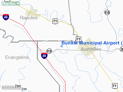
Bunkie Municipal Airport
Address:
Avoyelles Parish, LA
Tel:
318-346-7663, 318-346-6326
Images
and information placed above are from
http://www.airport-data.com/airport/2R6/
We
thank them for the data!
|
General Info |
| Country |
United
States |
| State |
LOUISIANA |
| FAA ID |
2R6
|
| Latitude |
30-57-24.290N |
|
Longitude |
092-14-02.759W |
|
Elevation |
62 feet
|
| Near
City |
BUNKIE
|
We don't guarantee the information is fresh and accurate. The data may
be wrong or outdated.
For more up-to-date information please refer to other sources.
|
|


