|
|
|
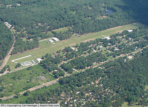 |
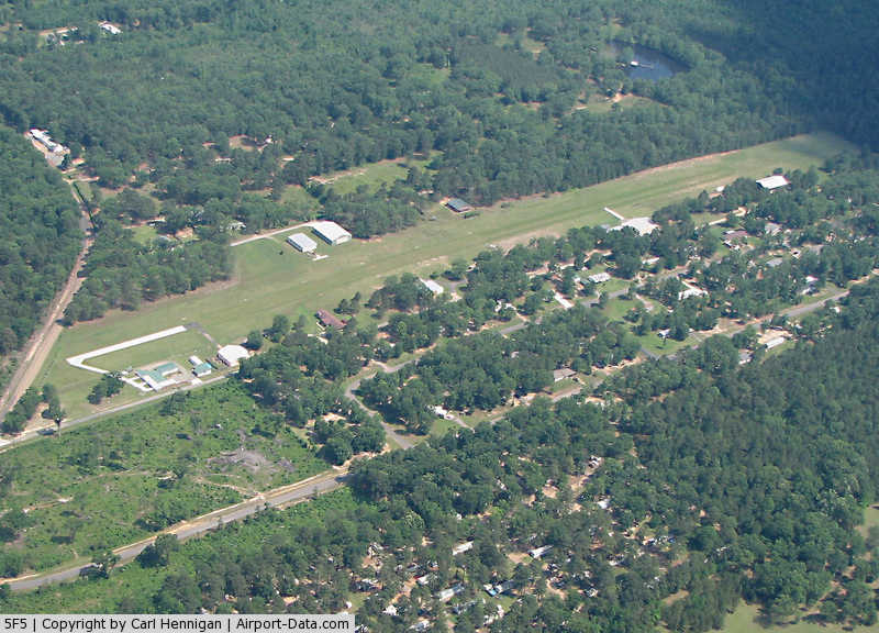
(Click on the photo to enlarge) |
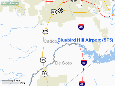
Location &
QuickFacts
|
FAA
Information Effective: |
2008-09-25 |
|
Airport
Identifier: |
5F5 |
|
Airport
Status: |
Operational |
|
Longitude/Latitude: |
093-47-59.6300W/32-20-40.5600N
-93.799897/32.344600 (Estimated) |
|
Elevation: |
180 ft / 54.86 m (Estimated) |
|
Land: |
26 acres |
|
From
nearest city: |
2 nautical miles NE of Keithville, LA |
|
Location: |
Caddo Parish, LA |
|
Magnetic Variation: |
05E (1985) |
Owner & Manager
|
Ownership: |
Privately owned |
|
Owner: |
Hugh R Hunton |
|
Address: |
2569 Barron Road
Keithville, LA 71047 |
|
Phone
number: |
318-925-2302 |
|
Manager: |
Hugh R Hunton |
|
Address: |
2569 Barron Road
Keithville, LA 71047 |
|
Phone
number: |
318-925-2302
TELEPHONE NUMBER FOR HUGH HUNTON. |
Airport
Operations and Facilities
|
Airport
Use: |
Open to public |
|
Wind
indicator: |
Yes |
|
Segmented Circle: |
No |
|
Control
Tower: |
No |
|
Lighting
Schedule: |
PHONE REQ
FOR ROTG BCN CALL 318-925-2302. |
|
Beacon
Color: |
Clear-Green (lighted land airport) |
|
Landing
fee charge: |
No |
|
Sectional chart: |
Memphis |
|
Region: |
ASW - Southwest |
|
Boundary
ARTCC: |
ZFW - Fort Worth |
|
Tie-in
FSS: |
DRI - De Ridder |
|
FSS on
Airport: |
No |
|
FSS Toll
Free: |
1-800-WX-BRIEF |
|
NOTAMs
Facility: |
DRI (NOTAM-d service avaliable) |
Airport Communications
Airport Services
|
Airframe
Repair: |
MINOR |
|
Power
Plant Repair: |
MINOR |
|
Runway Information
Runway 18/36
|
Dimension: |
3000 x 40 ft / 914.4 x 12.2 m |
|
Surface: |
ASPH-TURF, Good Condition
FIRST 430 FT RY 18 PAVED. |
|
Edge Lights: |
Low |
|
|
Runway 18
|
Runway 36
|
|
Longitude: |
093-47-59.6300W |
093-47-59.6300W |
|
Latitude: |
32-20-55.3800N |
32-20-25.7400N |
|
Traffic
Pattern: |
Left |
Left |
|
Displaced
threshold: |
430.00 ft
18/36 DSPLCD THLDS MKD WITH ONE ORANGE CONE ON EACH SIDE. |
850.00 ft |
|
Obstruction: |
50 ft trees, 620.0 ft from runway, 12:1 slope to clear
APCH RATIO 21:1 TO DSPLCD THLD. |
43 ft trees, 50.0 ft from runway, 1:1 slope to clear
APCH RATIO 20:1 TO DSPLCD THLD. |
|
Radio Navigation Aids
|
ID |
Type |
Name |
Ch |
Freq |
Var |
Dist |
|
MSD |
NDB |
Mansfield |
|
414.00 |
04E |
16.9 nm |
|
RPF |
NDB |
Carthage |
|
332.00 |
04E |
27.1 nm |
|
MNE |
NDB |
Minden |
|
201.00 |
04E |
30.9 nm |
|
VIV |
NDB |
Vivian |
|
284.00 |
06E |
32.7 nm |
|
CZJ |
NDB |
Amason |
|
341.00 |
04E |
35.6 nm |
|
SPH |
NDB |
Springhill |
|
375.00 |
05E |
39.9 nm |
|
MMY |
NDB |
Many |
|
272.00 |
04E |
48.3 nm |
|
HMQ |
NDB |
Homer |
|
212.00 |
02E |
48.5 nm |
|
ATA |
NDB |
Atlanta |
|
347.00 |
04E |
49.7 nm |
|
BAD |
TACAN |
Barksdale |
105X |
|
05E |
11.7 nm |
|
DTN |
VOR |
Downtown |
|
108.60 |
07E |
12.1 nm |
|
EMG |
VORTAC |
Elm Grove |
049X |
111.20 |
07E |
10.9 nm |
|
EIC |
VORTAC |
Belcher |
121X |
117.40 |
07E |
25.7 nm |
|
GGG |
VORTAC |
Gregg County |
070X |
112.30 |
07E |
48.6 nm |
|
SHV |
VOT |
Shreveport Regional |
|
108.20 |
|
16.3 nm |
Remarks
-
RWY 18/36 VERY
UNLEVEL GRADE FULL LENGTH; RWY ENDS STOP AT 50' TREES.
Based Aircraft
|
Aircraft based
on field: |
21 |
|
Single Engine
Airplanes: |
12 |
|
Gliders: |
4 |
|
Ultralights: |
5 |
Operational Statistics
Time Period: 2007-05-21 - 2008-05-19
|
Aircraft
Operations: |
106/Week |
|
General
Aviation Local: |
60.0% |
|
General
Aviation Itinerant: |
40.0% |
Bluebird Hill Airport
Address:
Caddo Parish, LA
Tel:
318-925-2302
Images
and information placed above are from
http://www.airport-data.com/airport/5F5/
We
thank them for the data!
|
General Info |
| Country |
United
States |
| State |
LOUISIANA |
| FAA ID |
5F5
|
| Latitude |
32-20-40.563N |
|
Longitude |
093-47-59.649W |
|
Elevation |
180 feet
|
| Near
City |
KEITHVILLE |
We don't guarantee the information is fresh and accurate. The data may
be wrong or outdated.
For more up-to-date information please refer to other sources.
|
|