 |
|
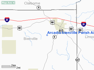
Arcadia-bienville Parish Airport |
|
|
Location &
QuickFacts
|
FAA
Information Effective: |
2008-09-25 |
|
Airport
Identifier: |
5F0 |
|
Airport
Status: |
Operational |
|
Longitude/Latitude: |
092-57-14.5720W/32-31-50.5480N
-92.954048/32.530708 (Estimated) |
|
Elevation: |
440 ft / 134.11 m (Estimated) |
|
Land: |
20 acres |
|
From
nearest city: |
2 nautical miles SW of Arcadia, LA |
|
Location: |
Bienville Parish, LA |
|
Magnetic Variation: |
04E (1985) |
Owner & Manager
|
Ownership: |
Publicly owned |
|
Owner: |
City Of Arcadia |
|
Address: |
Mayor's Office
Arcadia, LA 71001 |
|
Phone number: |
318-263-8455 |
|
Manager: |
Mike Smith |
|
Address: |
Po Box 767
Arcadia, LA 71001 |
|
Phone number: |
318-263-8455
OR 318-263-8824. |
Airport
Operations and Facilities
|
Airport
Use: |
Open to public |
|
Wind
indicator: |
Yes |
|
Segmented Circle: |
No |
|
Control
Tower: |
No |
|
Lighting
Schedule: |
DUSK-DAWN
ACTVT MIRL RY 14/32 - CTAF. |
|
Beacon
Color: |
Clear-Green (lighted land airport)
ROTATING BEACON 1 MILE SE OF AIRPORT. |
|
Landing
fee charge: |
No |
|
Sectional chart: |
Memphis |
|
Region: |
ASW - Southwest |
|
Boundary
ARTCC: |
ZFW - Fort Worth |
|
Tie-in
FSS: |
DRI - De Ridder |
|
FSS on
Airport: |
No |
|
FSS Toll
Free: |
1-800-WX-BRIEF |
|
NOTAMs
Facility: |
DRI (NOTAM-d service avaliable) |
Airport Communications
Airport Services
|
Airframe
Repair: |
NONE |
|
Power
Plant Repair: |
NONE |
|
Bottled
Oxygen: |
NONE |
|
Bulk
Oxygen: |
NONE |
|
Runway Information
Runway 14/32
|
Dimension: |
3000 x 75 ft / 914.4 x 22.9 m |
|
Surface: |
ASPH, |
|
Weight Limit: |
Single wheel: 16000 lbs. |
|
Edge Lights: |
Medium |
|
|
Runway 14
|
Runway 32
|
|
Traffic
Pattern: |
Left |
Left |
|
Markings: |
Basic, Good Condition |
Basic, Good Condition |
|
Runway End
Identifier: |
No |
No |
|
Obstruction: |
25 ft trees, 350.0 ft from runway, 100L/ ft right of
centerline, 6:1 slope to clear
+10 FT BRUSH 100 FT R & L IN PRIMARY SFC. |
12 ft trees, 243.0 ft from runway, 3:1 slope to clear
15 FT ROAD AND 4 FT FENCE 185 FT FM APCH END RY 32. |
|
Radio Navigation Aids
|
ID |
Type |
Name |
Ch |
Freq |
Var |
Dist |
|
HMQ |
NDB |
Homer |
|
212.00 |
02E |
15.8 nm |
|
MNE |
NDB |
Minden |
|
201.00 |
04E |
18.8 nm |
|
ROQ |
NDB |
Ruston |
|
368.00 |
03E |
19.1 nm |
|
TUF |
NDB |
Stuckey |
|
350.00 |
03E |
19.9 nm |
|
JBL |
NDB |
Hodge |
|
256.00 |
04E |
22.9 nm |
|
SPH |
NDB |
Springhill |
|
375.00 |
05E |
32.8 nm |
|
IFJ |
NDB |
Winnfield |
|
402.00 |
04E |
37.3 nm |
|
AGO |
NDB |
Magnolia |
|
266.00 |
04E |
43.9 nm |
|
MSD |
NDB |
Mansfield |
|
414.00 |
04E |
49.8 nm |
|
BAD |
TACAN |
Barksdale |
105X |
|
05E |
36.2 nm |
|
DTN |
VOR |
Downtown |
|
108.60 |
07E |
39.9 nm |
|
SWB |
VOR/DME |
Sawmill |
84Y |
113.75 |
02E |
36.3 nm |
|
EMG |
VORTAC |
Elm Grove |
049X |
111.20 |
07E |
33.4 nm |
|
ELD |
VORTAC |
El Dorado |
102X |
115.50 |
07E |
44.9 nm |
|
EIC |
VORTAC |
Belcher |
121X |
117.40 |
07E |
45.7 nm |
|
MLU |
VORTAC |
Monroe |
119X |
117.20 |
03E |
46.5 nm |
|
SHV |
VOT |
Shreveport Regional |
|
108.20 |
|
45.0 nm |
Remarks
-
GOLF COURSE
ADJACENT TO AIRPORT.
-
+4 FT FENCE 185
FT SOUTH OF RY 32 THLD.
Based Aircraft
|
Aircraft based
on field: |
5 |
|
Single Engine
Airplanes: |
5 |
Operational Statistics
Time Period: 2006-10-05 - 2007-10-04
|
Aircraft
Operations: |
72/Week |
|
General
Aviation Local: |
64.9% |
|
General
Aviation Itinerant: |
35.1% |
Arcadia-bienville Parish Airport
Address:
Bienville Parish, LA
Tel:
318-263-8455, 318-263-8455, 318-263-8824
Images
and information placed above are from
http://www.airport-data.com/airport/5F0/
We
thank them for the data!
|
General Info |
| Country |
United
States |
| State |
LOUISIANA |
| FAA ID |
5F0
|
| Latitude |
32-31-50.548N |
|
Longitude |
092-57-14.572W |
|
Elevation |
440 feet
|
| Near
City |
ARCADIA
|
We don't guarantee the information is fresh and accurate. The data may
be wrong or outdated.
For more up-to-date information please refer to other sources.
|
|


