 |
|
| Allen Parish Airport |
| IATA: none â ICAO: KACP â FAA LID: ACP |
| Summary |
| Airport type |
Public |
| Owner |
Allen Parish Police Jury |
| Serves |
Oakdale, Louisiana |
| Elevation AMSL |
107 ft / 33 m |
| Coordinates |
30°45â²01â³N 092°41â²18â³W / 30.75028°N 92.68833°W / 30.75028; -92.68833 |
| Runways |
| Direction |
Length |
Surface |
| ft |
m |
| 18/36 |
4,995 |
1,522 |
Asphalt |
| Statistics (2006) |
| Aircraft operations |
8,500 |
| Source: Federal Aviation Administration |
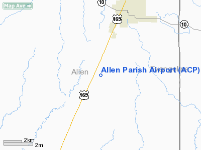
Allen Parish Airport (ICAO: KACP, FAA LID: ACP) is a public airport located four miles (6 km) south of the central business district of Oakdale, in Allen Parish, Louisiana, United States. It is owned by Allen Parish Police Jury.
Although most U.S. airports use the same three-letter location identifier for the FAA and IATA, Allen Parish Airport is assigned ACP by the FAA but has no designation from the IATA.
Facilities and aircraft
Allen Parish Airport covers an area of 538 acres (218 ha) which contains one asphalt paved runway (18/36) measuring 4,995 x 75 ft (1,522 x 23 m). For the 12-month period ending September 20, 2006, the airport had 8,500 aircraft operations, an average of 23 per day: 82% general aviation and 18% military.
The above content comes from Wikipedia and is published under free licenses – click here to read more.
Location &
QuickFacts
|
FAA
Information Effective: |
2008-09-25 |
|
Airport
Identifier: |
ACP |
|
Airport
Status: |
Operational |
|
Longitude/Latitude: |
092-41-18.5691W/30-45-01.7994N
-92.688491/30.750500 (Estimated) |
|
Elevation: |
107 ft / 32.61 m (Surveyed) |
|
Land: |
538 acres |
|
From
nearest city: |
4 nautical miles S of Oakdale, LA |
|
Location: |
Allen Parish, LA |
|
Magnetic Variation: |
03E (1995) |
Owner & Manager
|
Ownership: |
Publicly owned |
|
Owner: |
Allen Parish Police Jury |
|
Address: |
P. O. Drawer G
Oberlin, LA 70655 |
|
Phone number: |
337-639-4328 |
|
Manager: |
Joel B Johnson |
|
Address: |
278 Airport Road
Oakdale, LA 71463 |
|
Phone number: |
318-215-0090 |
Airport
Operations and Facilities
|
Airport
Use: |
Open to public |
|
Wind
indicator: |
Yes |
|
Segmented Circle: |
No |
|
Control
Tower: |
No |
|
Lighting
Schedule: |
DUSK-DAWN
MIRL RY 18/36 & REIL RYS 18 & 36 PRESET LOW INTST; TO INCR INTST ACTVT
- CTAF. |
|
Beacon
Color: |
Clear-Green (lighted land airport) |
|
Landing
fee charge: |
No |
|
Sectional chart: |
Houston |
|
Region: |
ASW - Southwest |
|
Boundary
ARTCC: |
ZHU - Houston |
|
Tie-in
FSS: |
DRI - De Ridder |
|
FSS on
Airport: |
No |
|
FSS Toll
Free: |
1-800-WX-BRIEF |
|
NOTAMs
Facility: |
DRI (NOTAM-d service avaliable) |
|
Federal Agreements: |
NGY |
Airport Communications
|
CTAF: |
122.800 |
|
Unicom: |
122.800 |
Airport Services
|
Fuel
available: |
100LLA
FUEL AVBL SELF SERVICE WITH CREDIT CARD. |
|
Airframe
Repair: |
NONE |
|
Power
Plant Repair: |
NONE |
|
Bottled
Oxygen: |
NONE |
|
Bulk
Oxygen: |
NONE |
|
Runway Information
Runway 18/36
|
Dimension: |
4994 x 75 ft / 1522.2 x 22.9 m |
|
Surface: |
ASPH, Good Condition |
|
Weight Limit: |
Single wheel: 11000 lbs. |
|
Edge Lights: |
Medium |
|
|
Runway 18
|
Runway 36
|
|
Longitude: |
092-41-18.3398W |
092-41-18.7984W |
|
Latitude: |
30-45-26.5130N |
30-44-37.0857N |
|
Elevation: |
101.00 ft |
107.00 ft |
|
Alignment: |
127 |
127 |
|
Traffic
Pattern: |
Left |
Left |
|
Markings: |
Non-precision instrument, Fair Condition
MARKINGS FADED. |
Non-precision instrument, Fair Condition
MARKINGS FADED. |
|
Crossing
Height: |
50.00 ft |
50.00 ft |
|
VASI: |
2-light PAPI on left side |
2-light PAPI on left side |
|
Visual
Glide Angle: |
3.00° |
3.00° |
|
Runway End
Identifier: |
Yes |
Yes |
|
Obstruction: |
30 ft trees, 400.0 ft from runway, 260 ft left of
centerline, 6:1 slope to clear |
50 ft trees, 1300.0 ft from runway, 22:1 slope to clear |
|
Radio Navigation Aids
|
ID |
Type |
Name |
Ch |
Freq |
Var |
Dist |
|
POE |
FAN MARKER |
South |
|
|
07E |
28.1 nm |
|
POE1 |
FAN MARKER |
North |
|
|
07E |
34.9 nm |
|
LRR |
NDB |
Allen Parish |
|
379.00 |
03E |
6.6 nm |
|
ECY |
NDB |
Eunice |
|
263.00 |
02E |
16.9 nm |
|
BWK |
NDB |
Bunkie |
|
397.00 |
03E |
24.5 nm |
|
GUV |
NDB |
Gator |
|
359.00 |
05E |
30.6 nm |
|
OPL |
NDB |
St Landry |
|
335.00 |
04E |
31.0 nm |
|
DR |
NDB |
Idder |
|
385.00 |
04E |
33.4 nm |
|
MKV |
NDB |
Marksville |
|
347.00 |
02E |
37.9 nm |
|
VED |
NDB |
Leesville |
|
247.00 |
04E |
39.8 nm |
|
DQU |
NDB |
De Quincy |
|
410.00 |
05E |
44.5 nm |
|
AEX |
VORTAC |
Alexandria |
108X |
116.10 |
03E |
31.9 nm |
|
FXU |
VORTAC |
Polk |
021X |
108.40 |
05E |
34.9 nm |
|
LCH |
VORTAC |
Lake Charles |
081X |
113.40 |
07E |
42.5 nm |
|
LFT |
VORTAC |
Lafayette |
035X |
109.80 |
03E |
49.2 nm |
Remarks
-
GCO AVBL ON FREQ
135.075 THRU POE APCH CTL & FLT SVCS.
Based Aircraft
|
Aircraft based
on field: |
10 |
|
Single Engine
Airplanes: |
9 |
|
Jet Engine
Airplanes: |
1 |
Operational Statistics
Time Period: 2006-09-20 - 2007-09-19
|
Aircraft
Operations: |
241/Week |
|
General
Aviation Local: |
64.0% |
|
General
Aviation Itinerant: |
24.0% |
|
Military: |
12.0% |
Allen Parish Airport
Address:
Allen Parish, LA
Tel:
337-639-4328, 318-215-0090
Images
and information placed above are from
http://www.airport-data.com/airport/ACP/
We
thank them for the data!
|
General Info |
| Country |
United
States |
| State |
LOUISIANA |
| FAA ID |
ACP
|
| Time |
UTC-6(-5DT) |
| Latitude |
30.750278
30° 45' 01.00" N |
|
Longitude |
-92.688333
092° 41' 18.00" W |
|
Elevation |
107 feet
33 meters |
| Magnetic
Variation |
002° E
(06/06) |
| Beacon |
Yes
|
|
Operating Agency |
U.S.CIVIL AIRPORT WHEREIN PERMIT COVERS USE BY TRANSIT MILITARY
AIRCRAFT |
| Near
City |
Oakdale
|
|
Operating Hours |
SEE
REMARKS FOR OPERATING HOURS OR COMMUNICATIONS FOR POSSIBLE HOURS
|
| Daylight
Saving Time |
Second
Sunday in March at 0200 to first Sunday in November at 0200 local time
(Exception Arizona and that portion of Indiana in the Eastern Time
Zone) |
We don't guarantee the information is fresh and accurate. The data may
be wrong or outdated.
For more up-to-date information please refer to other sources.
|
|


