 |
|
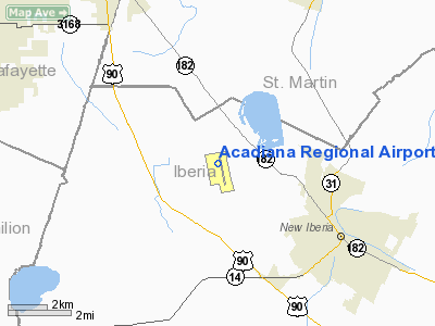
Acadiana Regional Airport |
| Acadiana Regional Airport |
| IATA: ARA â ICAO: KARA â FAA LID: ARA |
| Summary |
| Airport type |
Public |
| Owner |
Iberia Parish |
| Location |
New Iberia, Louisiana |
| Elevation AMSL |
24 ft / 7 m |
| Coordinates |
30°02â²16â³N 091°53â²02â³W / 30.03778°N 91.88389°W / 30.03778; -91.88389 |
| Website |
www.iberiabiz.com/... |
| Runways |
| Direction |
Length |
Surface |
| ft |
m |
| 16/34 |
8,002 |
2,439 |
Concrete |
| 16W/34W |
5,000 |
1,524 |
Water |
| Statistics (2007) |
| Aircraft operations |
95,851 |
| Based aircraft |
46 |
| Source: Federal Aviation Administration |
Acadiana Regional Airport (IATA: ARA, ICAO: KARA, FAA LID: ARA) is a public use airport in Iberia Parish, Louisiana, United States. It is owned by Iberia Parish and is located four nautical miles (7 km) northwest of the central business district of New Iberia, Louisiana.
Facilities and aircraft
Acadiana Regional Airport covers an area of 2,328 acres (942 ha) at an elevation of 24 feet (7 m) above mean sea level. It has one runway designated 16/34 which measures 8,002 by 200 feet (2,439 x 61 m). It also has one seaplane landing area designated 16W/34W which measures 5,000 by 150 feet (1,524 x 46 m).
For the 12-month period ending January 31, 2007, the airport had 95,851 aircraft operations, an average of 262 per day: 58% general aviation and 32% air taxi, 10% military and <1% scheduled commercial, At that time there were 46 aircraft based at this airport: 46% single-engine, 15% multi-engine, 2% jet and 37% helicopter.
The above content comes from Wikipedia and is published under free licenses – click here to read more.
Location &
QuickFacts
|
FAA
Information Effective: |
2008-09-25 |
|
Airport
Identifier: |
ARA |
|
Airport
Status: |
Operational |
|
Longitude/Latitude: |
091-53-02.0260W/30-02-15.9300N
-91.883896/30.037758 (Estimated) |
|
Elevation: |
24 ft / 7.32 m (Surveyed) |
|
Land: |
2328 acres |
|
From
nearest city: |
4 nautical miles NW of New Iberia, LA |
|
Location: |
Iberia Parish, LA |
|
Magnetic Variation: |
03E (1990) |
Owner & Manager
|
Ownership: |
Publicly owned |
|
Owner: |
Iberia Parish Goverment |
|
Address: |
300 Iberia St
New Iberia, LA 70560 |
|
Phone
number: |
337-365-8246 |
|
Manager: |
F. Jason Devillier |
|
Address: |
1404 Hangar Dr
New Iberia, LA 70560 |
|
Phone number: |
337-365-7202 |
Airport Operations and Facilities
|
Airport
Use: |
Open to public |
|
Wind
indicator: |
Yes |
|
Segmented Circle: |
Yes |
|
Control
Tower: |
Yes |
|
Lighting
Schedule: |
DUSK-DAWN
WHEN ATCT CLSD HIRL RY 16/34 PRESET LOW INTST; TO INCR INTST & ACTVT
MALSR RY 34 - CTAF. ACTVT SEAWAY EDGE LGTS RY 16W/34W - 122.7 3 CLICKS
ON 7 CLICKS OFF. |
|
Beacon
Color: |
Clear-Green (lighted land airport) |
|
Landing
fee charge: |
No |
|
Sectional chart: |
Houston |
|
Region: |
ASW - Southwest |
|
Traffic
Pattern Alt: |
1000 ft |
|
Boundary
ARTCC: |
ZHU - Houston |
|
Tie-in
FSS: |
DRI - De Ridder |
|
FSS on
Airport: |
No |
|
FSS Toll
Free: |
1-800-WX-BRIEF |
|
NOTAMs
Facility: |
ARA (NOTAM-d service avaliable) |
|
Certification type/date: |
IV A U 05/197
PPR FOR MORE THAN 30 PSGR SEATS CALL AMGR 337-365-7202. |
|
Federal Agreements: |
NGPY3 |
Airport Communications
|
CTAF: |
125.000 |
|
Unicom: |
122.950 |
Airport Services
|
Fuel
available: |
100LLA
FOR FUEL AFT HRS CALL 337-367-1401 FAX 337-367-1404. |
|
Airframe
Repair: |
MINOR |
|
Power
Plant Repair: |
MINOR |
|
Bottled
Oxygen: |
LOW |
|
Bulk
Oxygen: |
NONE |
|
Runway Information
Runway 16/34
|
Dimension: |
8002 x 200 ft / 2439.0 x 61.0 m |
|
Surface: |
CONC, Good Condition |
|
Weight Limit: |
Dual wheel: 105000 lbs.
Dual tandem wheel: 163000 lbs.
Dual dual tandem wheel: 400000 lbs. |
|
Edge Lights: |
High
SEAWAY EDGE LGTS GREEN; THLD LGTS AMBER. |
|
|
Runway 16
|
Runway 34
|
|
Longitude: |
091-53-11.8570W |
091-52-52.1668W |
|
Latitude: |
30-02-54.5814N |
30-01-37.2485N |
|
Elevation: |
24.00 ft |
19.00 ft |
|
Alignment: |
127 |
127 |
|
ILS Type: |
|
ILS |
|
Traffic
Pattern: |
Left |
Right |
|
Markings: |
Precision instrument, Fair Condition |
Precision instrument, Fair Condition |
|
Crossing
Height: |
50.00 ft |
50.00 ft |
|
VASI: |
4-light PAPI on left side |
4-light PAPI on left side |
|
Visual
Glide Angle: |
3.00° |
3.00° |
|
Approach
lights: |
ODALS |
MALSR |
|
Runway End
Identifier: |
No |
|
|
Decleard
distances: |
Take off run available 8002.00 ft
Take off distance available 8002.00 ft
Actual stop distance available 8002.00 ft
Landing distance available 8002.00 ft |
Take off run available 8002.00 ft
Take off distance available 8002.00 ft
Actual stop distance available 8002.00 ft
Landing distance available 8002.00 ft |
|
Runway 16W/34W
|
Dimension: |
5000 x 150 ft / 1524.0 x 45.7 m |
|
Surface: |
WATER, |
|
Edge Lights: |
Medium
SEAWAY EDGE LGTS GREEN; THLD LGTS AMBER. |
|
|
Runway 16W
|
Runway 34W
|
|
Traffic
Pattern: |
Right |
Left |
|
Decleard
distances: |
Take off run available 5000.00 ft
Take off distance available 5000.00 ft
Actual stop distance available 5000.00 ft
Landing distance available 5000.00 ft |
Take off run available 5000.00 ft
Take off distance available 5000.00 ft
Actual stop distance available 5000.00 ft
Landing distance available 5000.00 ft |
|
Radio Navigation Aids
|
ID |
Type |
Name |
Ch |
Freq |
Var |
Dist |
|
AR |
NDB |
Acadi |
|
269.00 |
03E |
5.0 nm |
|
PTN |
NDB |
Patterson |
|
245.00 |
01E |
34.5 nm |
|
OPL |
NDB |
St Landry |
|
335.00 |
04E |
38.8 nm |
|
HZ |
NDB |
Hazer |
|
356.00 |
04E |
41.2 nm |
|
ECY |
NDB |
Eunice |
|
263.00 |
02E |
42.9 nm |
|
LLA |
VOR/DME |
White Lake |
041X |
110.40 |
04E |
34.0 nm |
|
LFT |
VORTAC |
Lafayette |
035X |
109.80 |
03E |
11.0 nm |
|
BTR |
VORTAC |
Baton Rouge |
112X |
116.50 |
06E |
40.8 nm |
Remarks
-
ROTOR WING
MOVEMENT AND LANDING AREA BETWEEN THE RY AND SEAWAY.
-
INTENSIVE HELO TRAINING.
-
CAUTION SEAPLANE
LNDG AREA (WATER CHANNEL) WEST OF & ADJACENT/PARALLEL TO RWY.
-
PAEW SEAWAY AND
TWY B.
Based Aircraft
|
Aircraft based
on field: |
46 |
|
Single Engine
Airplanes: |
21 |
|
Multi Engine
Airplanes: |
7 |
|
Jet Engine
Airplanes: |
1 |
|
Helicopters: |
17 |
Operational Statistics
Time Period: 2006-02-01 - 2007-01-31
|
Aircraft
Operations: |
263/Day |
|
Commerical: |
0.2% |
|
Air Taxi: |
31.7% |
|
General
Aviation Local: |
48.8% |
|
General
Aviation Itinerant: |
9.0% |
|
Military: |
10.3% |
Acadiana Regional Airport
Address:
Iberia Parish, LA
Tel:
337-365-8246,
337-365-7202
Images
and information placed above are from
http://www.airport-data.com/airport/ARA/
We
thank them for the data!
|
General Info |
| Country |
United
States |
| State |
LOUISIANA |
| FAA ID |
ARA
|
| Latitude |
30-02-15.930N |
|
Longitude |
091-53-02.026W |
|
Elevation |
24 feet
|
| Near
City |
NEW
IBERIA |
We don't guarantee the information is fresh and accurate. The data may
be wrong or outdated.
For more up-to-date information please refer to other sources.
|
|


