 |
|
Abbeville Chris Crusta Memorial Airport |
| Abbeville Chris Crusta Memorial Airport |
| IATA: none â ICAO: none â FAA LID: 0R3 |
| Summary |
| Airport type |
Public |
| Owner |
City of Abbeville |
| Serves |
Abbeville, Louisiana |
| Elevation AMSL |
15 ft / 5 m |
| Coordinates |
29°58â²33â³N 092°05â²03â³W / 29.97583°N 92.08417°W / 29.97583; -92.08417 |
| Runways |
| Direction |
Length |
Surface |
| ft |
m |
| 15/33 |
5,000 |
1,524 |
Asphalt |
| Statistics (2007) |
| Aircraft operations |
92,345 |
| Based aircraft |
75 |
| Source: Federal Aviation Administration |
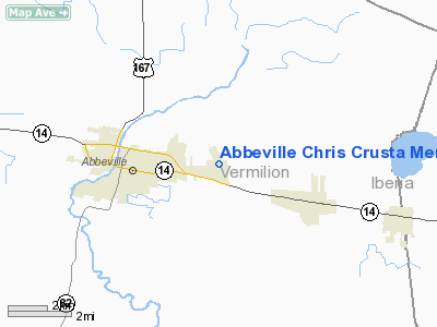
Abbeville Chris Crusta Memorial Airport (FAA LID: 0R3) is a city-owned public-use airport located three nautical miles (6 km) east of the central business district of Abbeville, a city in Vermilion Parish, Louisiana, United States.
Facilities and aircraft
Abbeville Chris Crusta Memorial Airport covers an area of 216 acres (87 ha) at an elevation of 15 feet (5 m) above mean sea level. It has one runway designated 15/33 with a 5,000 by 75 ft (1,524 x 23 m) asphalt surface.
For the 12-month period ending June 27, 2007, the airport had 92,345 aircraft operations, an average of 253 per day: 53% air taxi, 46% general aviation and 1% military. At that time there were 75 aircraft based at this airport: 49% single-engine, 40% helicopter, 4% multi-engine, 3% jet, 3% ultralight and 1% glider.
The above content comes from Wikipedia and is published under free licenses – click here to read more.
Location &
QuickFacts
|
FAA
Information Effective: |
2008-09-25 |
|
Airport
Identifier: |
0R3 |
|
Airport
Status: |
Operational |
|
Longitude/Latitude: |
092-05-02.9460W/29-58-32.7390N
-92.084152/29.975761 (Estimated) |
|
Elevation: |
15 ft / 4.57 m (Surveyed) |
|
Land: |
216 acres |
|
From
nearest city: |
3 nautical miles E of Abbeville, LA |
|
Location: |
Vermilion Parish, LA |
|
Magnetic Variation: |
02E (2005) |
Owner & Manager
|
Ownership: |
Publicly owned |
|
Owner: |
City Of Abbeville |
|
Address: |
Box 269
Abbeville, LA 70510 |
|
Phone
number: |
337-893-5841 |
|
Manager: |
Mike Mouton |
|
Address: |
112 Industrial Park Loop
Abbeville, LA 70510 |
|
Phone number: |
337-898-2268 |
Airport Operations and Facilities
|
Airport
Use: |
Open to public |
|
Wind
indicator: |
Yes |
|
Segmented Circle: |
No |
|
Control
Tower: |
No |
|
Lighting
Schedule: |
DUSK-DAWN
MIRL RY 15/33 & REIL RYS 15 & 33 PRESET LOW INTST; TO INCR INTST ACTVT
- CTAF. |
|
Beacon
Color: |
Clear-Green (lighted land airport) |
|
Landing
fee charge: |
No |
|
Sectional chart: |
Houston |
|
Region: |
ASW - Southwest |
|
Boundary
ARTCC: |
ZHU - Houston |
|
Tie-in
FSS: |
DRI - De Ridder |
|
FSS on
Airport: |
No |
|
FSS Toll
Free: |
1-800-WX-BRIEF |
|
NOTAMs
Facility: |
DRI (NOTAM-d service avaliable) |
|
Federal Agreements: |
NGY |
Airport Communications
|
CTAF: |
122.800 |
|
Unicom: |
122.800 |
Airport Services
|
Fuel
available: |
100LLA |
|
Airframe
Repair: |
MAJOR |
|
Power
Plant Repair: |
MAJOR |
|
Bottled
Oxygen: |
NONE |
|
Bulk
Oxygen: |
NONE |
|
Runway Information
Runway 15/33
|
Dimension: |
5000 x 75 ft / 1524.0 x 22.9 m |
|
Surface: |
ASPH, Good Condition
RY HAS SOME SMALL CRACKS. |
|
Surface
Treatment: |
Aggregate Friction Seal Coat |
|
Weight Limit: |
Single wheel: 17000 lbs. |
|
Edge Lights: |
Medium |
|
|
Runway 15
|
Runway 33
|
|
Longitude: |
092-05-13.5697W |
092-04-52.8571W |
|
Latitude: |
29-58-55.8216N |
29-58-09.7323N |
|
Elevation: |
16.00 ft |
16.00 ft |
|
Alignment: |
127 |
127 |
|
Traffic
Pattern: |
Left |
Left |
|
Markings: |
Non-precision instrument, Good Condition |
Non-precision instrument, Good Condition |
|
Crossing
Height: |
50.00 ft |
50.00 ft |
|
VASI: |
2-light PAPI on left side |
2-light PAPI on left side |
|
Visual
Glide Angle: |
3.00° |
3.00° |
|
Runway End
Identifier: |
Yes |
Yes |
|
Obstruction: |
4 ft fence, 357.0 ft from runway, 39:1 slope to clear |
60 ft trees, 1700.0 ft from runway, 25:1 slope to clear |
|
Radio Navigation Aids
|
ID |
Type |
Name |
Ch |
Freq |
Var |
Dist |
|
AR |
NDB |
Acadi |
|
269.00 |
03E |
11.6 nm |
|
ECY |
NDB |
Eunice |
|
263.00 |
02E |
39.9 nm |
|
OPL |
NDB |
St Landry |
|
335.00 |
04E |
40.9 nm |
|
PTN |
NDB |
Patterson |
|
245.00 |
01E |
42.0 nm |
|
LLA |
VOR/DME |
White Lake |
041X |
110.40 |
04E |
24.1 nm |
|
LFT |
VORTAC |
Lafayette |
035X |
109.80 |
03E |
13.9 nm |
Remarks
-
GCO AVBL ON FREQ
135.075 THRU LFT APCH & DRI AFSS.
Based Aircraft
|
Aircraft based
on field: |
75 |
|
Single Engine
Airplanes: |
37 |
|
Multi Engine
Airplanes: |
3 |
|
Jet Engine
Airplanes: |
2 |
|
Helicopters: |
30 |
|
Gliders: |
1 |
|
Ultralights: |
2 |
Operational Statistics
Time Period: 2006-06-28 - 2007-06-27
|
Aircraft
Operations: |
253/Day |
|
Air Taxi: |
53.0% |
|
General
Aviation Local: |
27.4% |
|
General
Aviation Itinerant: |
18.7% |
|
Military: |
0.9% |
Abbeville Chris Crusta Memorial Airport
Address:
Vermilion Parish, LA
Tel:
337-893-5841,
337-898-2268
Images
and information placed above are from
http://www.airport-data.com/airport/0R3/
We
thank them for the data!
|
General Info |
| Country |
United
States |
| State |
LOUISIANA |
| FAA ID |
0R3
|
| Latitude |
29-58-32.739N |
|
Longitude |
092-05-02.946W |
|
Elevation |
15 feet
|
| Near
City |
ABBEVILLE |
We don't guarantee the information is fresh and accurate. The data may
be wrong or outdated.
For more up-to-date information please refer to other sources.
|
|


