 |
|
|
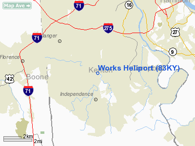
Location &
QuickFacts
|
FAA
Information Effective: |
2008-09-25 |
|
Airport
Identifier: |
83KY |
|
Airport
Status: |
Operational |
|
Longitude/Latitude: |
084-32-41.0000W/38-58-52.0000N
-84.544722/38.981111 (Estimated) |
|
Elevation: |
800 ft / 243.84 m (Estimated) |
|
Land: |
0 acres |
|
From
nearest city: |
1 nautical miles ES of Erlanger, KY |
|
Location: |
Kenton County, KY |
|
Magnetic Variation: |
() |
Owner & Manager
|
Ownership: |
Privately owned |
|
Owner: |
Mark Works |
|
Address: |
211 Grandview Drive #112
Ft Mitchell, KY 41017 |
|
Phone
number: |
859-653-9115 |
|
Manager: |
Mark Works |
|
Address: |
211 Grandview Drive #112
Ft Mitchell, KY 41017 |
|
Phone number: |
859-653-9115 |
Airport Operations and Facilities
|
Airport
Use: |
Private |
|
Control
Tower: |
No |
|
Sectional chart: |
Cincinnati |
|
Region: |
ASO - Southern |
|
Boundary
ARTCC: |
ZID - Indianapolis |
|
Tie-in
FSS: |
LOU - Louisville |
|
FSS Toll
Free: |
1-800-WX-BRIEF |
|
Runway Information
Helipad H1
|
Dimension: |
60 x 60 ft / 18.3 x 18.3 m |
|
Surface: |
TURF, |
|
|
Runway H1
|
Runway
|
|
Traffic
Pattern: |
Left |
Left |
|
Radio Navigation Aids
|
ID |
Type |
Name |
Ch |
Freq |
Var |
Dist |
|
UR |
NDB |
Burln |
|
321.00 |
04W |
11.4 nm |
|
LUK |
NDB |
Cincinnati |
|
335.00 |
04W |
14.3 nm |
|
PWF |
NDB |
Sportys |
|
245.00 |
04W |
16.4 nm |
|
MDE |
NDB |
Madeira |
|
379.00 |
04W |
17.0 nm |
|
ISZ |
NDB |
Cincinnati-blue Ash |
|
388.00 |
04W |
17.6 nm |
|
HAO |
NDB |
Hamilton |
|
260.00 |
04W |
23.6 nm |
|
HKF |
NDB |
Hook Field |
|
239.00 |
04W |
31.4 nm |
|
OXD |
NDB |
Oxford |
|
282.00 |
04W |
33.5 nm |
|
HW |
NDB |
Cubla |
|
299.00 |
04W |
38.4 nm |
|
HLB |
NDB |
Batesville |
|
254.00 |
02W |
39.9 nm |
|
IMS |
NDB |
Madison |
|
404.00 |
03W |
44.9 nm |
|
AMT |
NDB |
West Union |
|
359.00 |
04W |
46.5 nm |
|
FEU |
NDB |
Arnold |
|
521.00 |
03W |
47.8 nm |
|
HOC |
NDB |
Hillsboro |
|
278.00 |
05W |
48.3 nm |
|
IL |
NDB |
Airbo |
|
407.00 |
04W |
48.6 nm |
|
XW |
NDB |
Flmng |
|
400.00 |
05W |
48.7 nm |
|
OVO |
NDB |
North Vernon |
|
374.00 |
02W |
49.5 nm |
|
FLM |
VOR/DME |
Falmouth |
117X |
117.00 |
04W |
22.7 nm |
|
MXQ |
VOR/DME |
Midwest |
076X |
112.90 |
04W |
43.9 nm |
|
CVG |
VORTAC |
Cincinnati |
120X |
117.30 |
04W |
7.7 nm |
|
RID |
VORTAC |
Richmond |
043X |
110.60 |
03W |
48.5 nm |
|
LUK |
VOT |
Cincinnati Muni/lunken |
|
108.40 |
|
10.6 nm |
Remarks
-
PVDD VFR OPNS,
PRIVATE USE, 75 FT TREES NE OF HEILPAD ARE REMOVED, APCH/DEP FROM 045 TO 120
DEGS, AREA IS MARKED, WIND INDICATOR IS MAINTAINED, PILOT COMPLIES WITH OPNS
REQ FOR 30 NM CLASS B AIRSPACE.
Based Aircraft
|
Aircraft based
on field: |
1 |
|
Helicopters: |
1 |
Works Heliport
Address:
Kenton County, KY
Tel:
859-653-9115
Images
and information placed above are from
http://www.airport-data.com/airport/83KY/
We
thank them for the data!
|
|


