 |
|
|
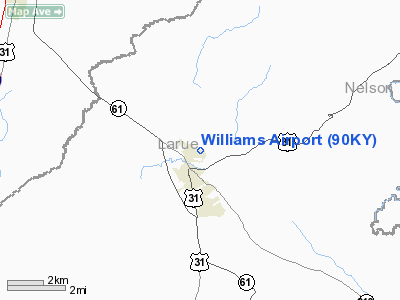
Location &
QuickFacts
|
FAA
Information Effective: |
2008-09-25 |
|
Airport
Identifier: |
90KY |
|
Airport
Status: |
Operational |
|
Longitude/Latitude: |
085-43-59.8580W/37-34-57.2190N
-85.733294/37.582561 (Estimated) |
|
Elevation: |
760 ft / 231.65 m (Estimated) |
|
Land: |
4 acres |
|
From
nearest city: |
1 nautical miles N of Hodgenville, KY |
|
Location: |
Larue County, KY |
|
Magnetic Variation: |
02W (1990) |
Owner & Manager
|
Ownership: |
Privately owned |
|
Owner: |
Robert E. Williams |
|
Address: |
300 Phillips Lane
Hodgenville, KY 42748 |
|
Phone number: |
502-358-3693 |
|
Address: |
|
Airport
Operations and Facilities
|
Airport
Use: |
Private |
|
Wind
indicator: |
Yes |
|
Segmented Circle: |
No |
|
Control
Tower: |
No |
|
Sectional chart: |
St Louis |
|
Region: |
ASO - Southern |
|
Boundary
ARTCC: |
ZID - Indianapolis |
|
Tie-in
FSS: |
LOU - Louisville |
|
FSS on
Airport: |
No |
|
FSS Toll
Free: |
1-800-WX-BRIEF |
|
Runway Information
Runway 09/27
|
Dimension: |
1800 x 75 ft / 548.6 x 22.9 m |
|
Surface: |
TURF, |
|
|
Runway 09
|
Runway 27
|
|
Traffic
Pattern: |
Left |
Left |
|
Obstruction: |
40 ft wires, 50.0 ft from runway |
40 ft wires, 50.0 ft from runway |
|
Radio Navigation Aids
|
ID |
Type |
Name |
Ch |
Freq |
Var |
Dist |
|
BRY |
NDB |
Bardstown/dcmsnd |
|
248.00 |
02W |
19.9 nm |
|
IKY |
NDB |
Springfield |
|
429.00 |
03W |
23.9 nm |
|
GOI |
NDB |
Godman |
|
396.00 |
02W |
25.4 nm |
|
TYC |
NDB |
Taylor County |
|
272.00 |
02W |
25.8 nm |
|
BVQ |
NDB |
Beaver Creek |
|
260.00 |
02W |
36.4 nm |
|
DVK |
NDB |
Goodall |
|
311.00 |
03W |
46.2 nm |
|
MYS |
VOR |
Mystic |
|
108.20 |
01W |
30.7 nm |
|
EWO |
VOR/DME |
New Hope |
045X |
110.80 |
01E |
4.0 nm |
|
FTK |
VOR/DME |
Fort Knox |
033X |
109.60 |
01W |
22.6 nm |
|
BQM |
VOR/DME |
Bowman |
059X |
112.20 |
01W |
39.1 nm |
|
IIU |
VORTAC |
Louisville |
095X |
114.80 |
01E |
32.2 nm |
|
SDF |
VOT |
Louisville Standifd |
|
111.00 |
|
35.8 nm |
Remarks
-
PRVDD ALL OPNS
CONDUCTED IN VFR WX AND LIMITED TO PVT USE.
Based Aircraft
|
Aircraft based
on field: |
1 |
|
Single Engine
Airplanes: |
1 |
Williams Airport
Address:
Larue County, KY
Tel:
502-358-3693
Images
and information placed above are from
http://www.airport-data.com/airport/90KY/
We
thank them for the data!
|
General Info |
| Country |
United
States |
| State |
KENTUCKY
|
| FAA ID |
90KY
|
| Latitude |
37-34-57.219N |
|
Longitude |
085-43-59.858W |
|
Elevation |
760 feet
|
| Near
City |
HODGENVILLE |
We don't guarantee the information is fresh and accurate. The data may
be wrong or outdated.
For more up-to-date information please refer to other sources.
|
|


