 |
|
|
|
|
|
|
Location &
QuickFacts
|
FAA
Information Effective: |
2008-09-25 |
|
Airport
Identifier: |
9I3 |
|
Airport
Status: |
Operational |
|
Longitude/Latitude: |
083-15-07.6360W/37-54-52.3130N
-83.252121/37.914531 (Estimated) |
|
Elevation: |
934 ft / 284.68 m (Surveyed) |
|
Land: |
40 acres |
|
From
nearest city: |
1 nautical miles S of West Liberty, KY |
|
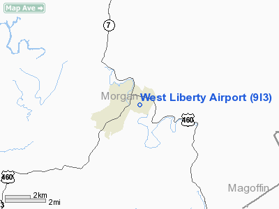
Location: |
Morgan County, KY |
|
Magnetic Variation: |
04W (1985) |
Owner & Manager
|
Ownership: |
Publicly owned |
|
Owner: |
West Liberty & Morgan County
COUNTY JUDGE/EXECUTIVE |
|
Address: |
Morgan Co Office Bldg
West Liberty, KY 41472 |
|
Phone
number: |
606-743-3898 |
|
Manager: |
Jerry Mays |
|
Address: |
787 Centerville Road
West Liberty, KY 41472 |
|
Phone number: |
606-743-4703
JERRY MAYS-BOARD CHAIRMAN |
Airport
Operations and Facilities
|
Airport
Use: |
Open to public |
|
Wind
indicator: |
Yes |
|
Segmented Circle: |
Yes |
|
Control
Tower: |
No |
|
Landing
fee charge: |
No |
|
Sectional chart: |
Cincinnati |
|
Region: |
ASO - Southern |
|
Boundary
ARTCC: |
ZID - Indianapolis |
|
Tie-in
FSS: |
LOU - Louisville |
|
FSS on
Airport: |
No |
|
FSS Toll
Free: |
1-800-WX-BRIEF |
|
NOTAMs
Facility: |
LOU (NOTAM-d service avaliable) |
|
Federal Agreements: |
N1 |
Airport Communications
Airport Services
|
Airframe
Repair: |
NONE |
|
Power
Plant Repair: |
NONE |
|
Bottled
Oxygen: |
NONE |
|
Bulk
Oxygen: |
NONE |
|
Runway Information
Runway 07/25
|
Dimension: |
2400 x 60 ft / 731.5 x 18.3 m |
|
Surface: |
ASPH, Good Condition |
|
Weight Limit: |
Single wheel: 9000 lbs. |
|
|
Runway 07
|
Runway 25
|
|
Traffic
Pattern: |
Left |
Left |
|
Markings: |
Basic, Fair Condition |
Basic, Fair Condition |
|
Obstruction: |
35 ft trees, 317.0 ft from runway, 40 ft right of
centerline, 3:1 slope to clear |
17 ft trees, 453.0 ft from runway, 100 ft left of
centerline, 14:1 slope to clear |
|
Radio Navigation Aids
|
ID |
Type |
Name |
Ch |
Freq |
Var |
Dist |
|
AJY |
FAN MARKER |
Ashland |
|
|
03W |
44.3 nm |
|
IOB |
NDB |
Mount Sterling |
|
210.00 |
04W |
35.6 nm |
|
XYC |
NDB |
Seco |
|
393.00 |
03W |
38.1 nm |
|
XW |
NDB |
Flmng |
|
400.00 |
05W |
43.8 nm |
|
AZQ |
VOR/DME |
Hazard |
049X |
111.20 |
04W |
31.5 nm |
|
ECB |
VORTAC |
Newcombe |
041X |
110.40 |
02W |
21.8 nm |
|
YRK |
VORTAC |
York |
075X |
112.80 |
05W |
45.7 nm |
Remarks
-
USE CAUTION IN
TAXIING-GRVL TWY/APRON ELEVATED ABOVE RWYS.
-
TREES & TERRAIN
BOTH SIDES OF RWY VIOLATE 7:1 TRANSITIONAL SURFACE.
-
VFR OPNS ONLY
Based Aircraft
|
Aircraft based
on field: |
7 |
|
Single Engine
Airplanes: |
7 |
Operational Statistics
Time Period: 2005-08-12 - 2006-08-11
|
Aircraft
Operations: |
51/Week |
|
Air Taxi: |
3.8% |
|
General
Aviation Local: |
46.0% |
|
General
Aviation Itinerant: |
49.8% |
|
Military: |
0.4% |
West Liberty Airport
Address:
Morgan County, KY
Tel:
606-743-3898,
606-743-4703
Images
and information placed above are from
http://www.airport-data.com/airport/9I3/
We
thank them for the data!
|
General Info |
| Country |
United
States |
| State |
KENTUCKY
|
| FAA ID |
9I3
|
| Latitude |
37-54-52.313N |
|
Longitude |
083-15-07.636W |
|
Elevation |
934 feet
|
| Near
City |
WEST
LIBERTY |
We don't guarantee the information is fresh and accurate. The data may
be wrong or outdated.
For more up-to-date information please refer to other sources.
|
|


