 |
|
|
|
|
|
|
Location &
QuickFacts
|
FAA
Information Effective: |
2008-09-25 |
|
Airport
Identifier: |
EKQ |
|
Airport
Status: |
Operational |
|
Longitude/Latitude: |
084-51-22.1000W/36-51-19.0000N
-84.856139/36.855278 (Estimated) |
|
Elevation: |
963 ft / 293.52 m (Surveyed) |
|
Land: |
121 acres |
|
From
nearest city: |
2 nautical miles N of Monticello, KY |
|
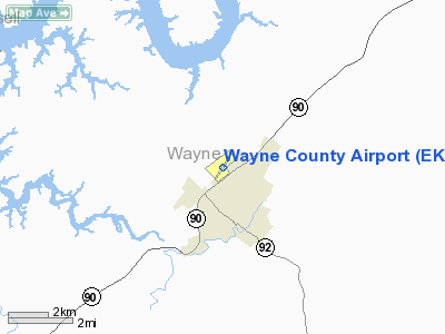
Location: |
Wayne County, KY |
|
Magnetic Variation: |
03W (1990) |
Owner & Manager
|
Ownership: |
Publicly owned |
|
Owner: |
Wayne Co Arpt Board |
|
Address: |
Rt 3, Box 750
Monticello, KY 42633 |
|
Phone
number: |
606-307-3706
ARPT BOARD CHAIRMAN RALPH DAVIS. |
|
Manager: |
Joe Huff |
|
Address: |
Rt 3, Box 750
Monticello, KY 42633 |
|
Phone number: |
606-348-7700 |
Airport
Operations and Facilities
|
Airport
Use: |
Open to public |
|
Wind
indicator: |
Yes |
|
Segmented Circle: |
Yes |
|
Control
Tower: |
No |
|
Lighting
Schedule: |
DUSK-DAWN
MIRL RY 03/21 PRESET LOW INTST; TO INCR INTST & ACTVT REIL RY 21 -
CTAF. |
|
Beacon
Color: |
Clear-Green (lighted land airport) |
|
Landing
fee charge: |
No |
|
Sectional chart: |
Cincinnati |
|
Region: |
ASO - Southern |
|
Boundary
ARTCC: |
ZID - Indianapolis |
|
Tie-in
FSS: |
LOU - Louisville |
|
FSS on
Airport: |
No |
|
FSS Toll
Free: |
1-800-WX-BRIEF |
|
NOTAMs
Facility: |
LOU (NOTAM-d service avaliable) |
|
Federal Agreements: |
NGY |
Airport Communications
|
CTAF: |
122.800 |
|
Unicom: |
122.800 |
Airport Services
|
Fuel
available: |
100LLA |
|
Airframe
Repair: |
MAJOR |
|
Power
Plant Repair: |
MAJOR |
|
Bottled
Oxygen: |
NONE |
|
Bulk
Oxygen: |
NONE |
|
Runway Information
Runway 03/21
|
Dimension: |
4000 x 75 ft / 1219.2 x 22.9 m |
|
Surface: |
ASPH, Good Condition |
|
Weight Limit: |
Single wheel: 12500 lbs. |
|
Edge Lights: |
Medium |
|
|
Runway 03
|
Runway 21
|
|
Longitude: |
084-51-36.4329W |
084-51-07.6715W |
|
Latitude: |
36-51-02.9021N |
36-51-34.9949N |
|
Elevation: |
959.00 ft |
963.00 ft |
|
Alignment: |
36 |
127 |
|
Traffic
Pattern: |
Left |
Left |
|
Markings: |
Non-precision instrument, Good Condition |
Non-precision instrument, Good Condition |
|
Crossing
Height: |
0.00 ft |
27.00 ft |
|
VASI: |
|
2-box SAVASI on left side |
|
Visual
Glide Angle: |
0.00° |
4.00° |
|
Runway End
Identifier: |
Yes
OTS INDEFLY. |
Yes |
|
Obstruction: |
42 ft trees, 1250.0 ft from runway, 150 ft left of
centerline, 25:1 slope to clear |
100 ft tree, 2100.0 ft from runway, 200 ft right of
centerline, 19:1 slope to clear |
|
Radio Navigation Aids
|
ID |
Type |
Name |
Ch |
Freq |
Var |
Dist |
|
EKQ |
NDB |
Elk Spring |
|
290.00 |
03W |
0.2 nm |
|
CDX |
NDB |
Cumberland River |
|
388.00 |
05E |
11.9 nm |
|
BPO |
NDB |
Piney Grove |
|
403.00 |
05W |
26.4 nm |
|
TYC |
NDB |
Taylor County |
|
272.00 |
02W |
37.7 nm |
|
DVK |
NDB |
Goodall |
|
311.00 |
03W |
43.6 nm |
|
JAU |
NDB |
Jacksboro |
|
204.00 |
03W |
45.7 nm |
|
LVT |
VORTAC |
Livingston |
021X |
108.40 |
02W |
22.1 nm |
|
LOZ |
VORTAC |
London |
108X |
116.10 |
03W |
37.4 nm |
Remarks
Based Aircraft
|
Aircraft based
on field: |
22 |
|
Single Engine
Airplanes: |
15 |
|
Multi Engine
Airplanes: |
5 |
|
Helicopters: |
2 |
Operational Statistics
Time Period: 2006-09-22 - 2007-09-21
|
Aircraft
Operations: |
163/Week |
|
Air Taxi: |
9.5% |
|
General
Aviation Local: |
34.2% |
|
General
Aviation Itinerant: |
54.5% |
|
Military: |
1.8% |
Wayne County Airport
Address:
Wayne County, KY
Tel:
606-307-3706, 606-348-7700
Images
and information placed above are from
http://www.airport-data.com/airport/EKQ/
We
thank them for the data!
|
General Info |
| Country |
United
States |
| State |
KENTUCKY
|
| FAA ID |
EKQ
|
| Latitude |
36-51-19.000N |
|
Longitude |
084-51-22.100W |
|
Elevation |
963 feet
|
| Near
City |
MONTICELLO |
We don't guarantee the information is fresh and accurate. The data may
be wrong or outdated.
For more up-to-date information please refer to other sources.
|
|


