 |
|
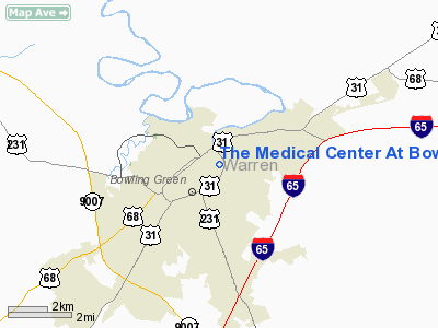
The Medical Center At Bowling Green Heliport |
|
Location &
QuickFacts
|
FAA
Information Effective: |
2008-09-25 |
|
Airport
Identifier: |
2KY6 |
|
Airport
Status: |
Operational |
|
Longitude/Latitude: |
086-25-45.0000W/36-59-41.0000N
-86.429167/36.994722 (Estimated) |
|
Elevation: |
494 ft / 150.57 m (Estimated) |
|
Land: |
1 acres |
|
From
nearest city: |
0 nautical miles E of Bowling Green, KY |
|
Location: |
Warren County, KY |
|
Magnetic Variation: |
02W (1995) |
Owner & Manager
|
Ownership: |
Privately owned |
|
Owner: |
The Medical Center At Bowling Green |
|
Address: |
250 Park Street
Bowling Green, KY 42101 |
|
Phone
number: |
502-745-1090 |
|
Manager: |
David Southard |
|
Address: |
250 Park Street
Bowling Green, KY 42101 |
|
Phone number: |
502-745-1350 |
Airport Operations and Facilities
|
Airport
Use: |
Private |
|
Wind
indicator: |
Yes |
|
Segmented Circle: |
No |
|
Control
Tower: |
No |
|
Lighting
Schedule: |
PHONE REQ
FOR PERIMETER LGTS CALL 502-745-1350. |
|
Sectional chart: |
St Louis |
|
Region: |
ASO - Southern |
|
Boundary
ARTCC: |
ZME - Memphis |
|
Tie-in
FSS: |
LOU - Louisville |
|
FSS Toll
Free: |
1-800-WX-BRIEF |
|
Runway Information
Helipad H1
|
Dimension: |
60 x 60 ft / 18.3 x 18.3 m |
|
Surface: |
CONC, |
|
|
Runway H1
|
Runway
|
|
Traffic
Pattern: |
Left |
Left |
|
Radio Navigation Aids
|
ID |
Type |
Name |
Ch |
Freq |
Var |
Dist |
|
BVQ |
NDB |
Beaver Creek |
|
260.00 |
02W |
20.2 nm |
|
LFB |
NDB |
Lafayette |
|
245.00 |
02W |
33.8 nm |
|
PED |
NDB |
Needmore |
|
221.00 |
01W |
36.2 nm |
|
GMH |
NDB |
Muhlenberg |
|
362.00 |
01E |
37.7 nm |
|
ON |
NDB |
Music |
|
279.00 |
03W |
42.6 nm |
|
HIX |
NDB |
Honey Grove |
|
356.00 |
01W |
44.2 nm |
|
JUE |
NDB |
Lebanon |
|
414.00 |
02W |
48.6 nm |
|
VI |
NDB |
Opery |
|
344.00 |
02W |
48.7 nm |
|
FK |
NDB |
Airbe |
|
273.00 |
01W |
49.8 nm |
|
BWG |
VORTAC |
Bowling Green |
126X |
117.90 |
02E |
4.0 nm |
|
CCT |
VORTAC |
Central City |
035X |
109.80 |
01W |
46.3 nm |
Remarks
-
SEE AIRSPACE CASE
97-MEM-043-NRA.
The Medical Center At Bowling Green
Heliport
Address:
Warren County, KY
Tel:
502-745-1090,
502-745-1350
Images
and information placed above are from
http://www.airport-data.com/airport/2KY6/
We
thank them for the data!
|
General Info |
| Country |
United
States |
| State |
KENTUCKY
|
| FAA ID |
2KY6
|
| Latitude |
36-59-41.000N |
|
Longitude |
086-25-45.000W |
|
Elevation |
494 feet
|
| Near
City |
BOWLING
GREEN |
We don't guarantee the information is fresh and accurate. The data may
be wrong or outdated.
For more up-to-date information please refer to other sources.
|
|


