 |
|
Coordinates: 37°21â²30â³N 085°18â²34â³W / 37.35833°N 85.30944°W / 37.35833; -85.30944
| Taylor County Airport |
 |
| IATA: none â ICAO: KAAS â FAA LID: AAS |
| Summary |
| Airport type |
Public |
| Owner |
Taylor County Airport Board |
| Location |
Campbellsville, Kentucky |
| Elevation AMSL |
921 ft / 281 m |
| Runways |
| Direction |
Length |
Surface |
| ft |
m |
| 5/23 |
5,003 |
1,525 |
Asphalt |
| Statistics (2006) |
| Aircraft operations |
10,200 |
| Source: Federal Aviation Administration |
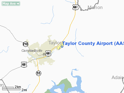
Taylor County Airport (ICAO: KAAS, FAA LID: AAS) is a county-owned public-use airport located two nautical miles (4 km) northeast of the central business district of Campbellsville, a city in Taylor County, Kentucky, United States.
Although most U.S. airports use the same three-letter location identifier for the FAA and IATA, Taylor County Airport is assigned AAS by the FAA but has no designation from the IATA (which assigned AAS to Apalapsili, Indonesia).
Facilities and aircraft
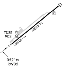
Taylor County Airport covers an area of 106 acres (43 ha) at an elevation of 921 feet (281 m) above mean sea level. It has one asphalt paved runway designated 5/23 which measures 5,003 x 75 feet (1,525 x 23 m). For the 12-month period ending May 19, 2006, the airport had 10,200 aircraft operations, an average of 27 per day: 75% general aviation, 16% air taxi and 9% military.
The above content comes from Wikipedia and is published under free licenses – click here to read more.
|
Location &
QuickFacts
|
FAA
Information Effective: |
2008-09-25 |
|
Airport
Identifier: |
AAS |
|
Airport
Status: |
Operational |
|
Longitude/Latitude: |
085-18-33.9000W/37-21-29.8000N
-85.309417/37.358278 (Estimated) |
|
Elevation: |
921 ft / 280.72 m (Surveyed) |
|
Land: |
106 acres |
|
From
nearest city: |
2 nautical miles NE of Campbellsville, KY |
|
Location: |
Taylor County, KY |
|
Magnetic Variation: |
02W (1985) |
Owner & Manager
|
Ownership: |
Publicly owned |
|
Owner: |
Airport Board |
|
Address: |
Po Box 1093
Campbellsville, KY 42719 |
|
Phone
number: |
270-465-8931
AIR BOARD CHAIRMAN: CARL WATSON. |
|
Manager: |
Karen Hall |
|
Address: |
360 Airport Road
Campbellsville, KY 42718 |
|
Phone number: |
270-465-7455
ALSO 270-789-4182. |
Airport
Operations and Facilities
|
Airport
Use: |
Open to public |
|
Wind
indicator: |
Yes |
|
Segmented Circle: |
Yes |
|
Control
Tower: |
No |
|
Lighting
Schedule: |
DUSK-DAWN
MIRL RY 05/23 PRESET ON LOW INTST; TO INCR INTST & ACTVT REIL RYS 05 &
23 - CTAF. |
|
Beacon
Color: |
Clear-Green (lighted land airport) |
|
Landing
fee charge: |
No |
|
Sectional chart: |
St Louis |
|
Region: |
ASO - Southern |
|
Boundary
ARTCC: |
ZID - Indianapolis |
|
Tie-in
FSS: |
LOU - Louisville |
|
FSS on
Airport: |
No |
|
FSS Toll
Free: |
1-800-WX-BRIEF |
|
NOTAMs
Facility: |
LOU (NOTAM-d service avaliable) |
|
Federal Agreements: |
NGY3 |
Airport Communications
|
CTAF: |
122.700 |
|
Unicom: |
122.700 |
Airport Services
|
Fuel
available: |
100LLA
FUEL AVBL AFTER HRS WITH CREDIT CARD. |
|
Bottled
Oxygen: |
NONE |
|
Bulk
Oxygen: |
NONE |
|
Runway Information
Runway 05/23
|
Dimension: |
5003 x 75 ft / 1524.9 x 22.9 m |
|
Surface: |
ASPH, Good Condition |
|
Weight Limit: |
Single wheel: 30000 lbs. |
|
Edge Lights: |
Medium |
|
|
Runway 05
|
Runway 23
|
|
Longitude: |
085-18-57.6330W |
085-18-10.2340W |
|
Latitude: |
37-21-13.8340N |
37-21-45.6950N |
|
Elevation: |
871.00 ft |
920.00 ft |
|
Alignment: |
50 |
127 |
|
ILS Type: |
|
SDF |
|
Traffic
Pattern: |
Left |
Left |
|
Markings: |
Non-precision instrument, Fair Condition |
Non-precision instrument, Good Condition |
|
Crossing
Height: |
39.00 ft |
37.00 ft |
|
VASI: |
4-light PAPI on left side |
4-light PAPI on left side |
|
Visual
Glide Angle: |
3.50° |
3.25° |
|
Runway End
Identifier: |
Yes |
Yes |
|
Obstruction: |
14 ft road, 493.0 ft from runway, 20:1 slope to clear |
65 ft trees, 2372.0 ft from runway, 488 ft right of
centerline, 33:1 slope to clear |
|
Radio Navigation Aids
|
ID |
Type |
Name |
Ch |
Freq |
Var |
Dist |
|
TYC |
NDB |
Taylor County |
|
272.00 |
02W |
4.1 nm |
|
IKY |
NDB |
Springfield |
|
429.00 |
03W |
17.0 nm |
|
DVK |
NDB |
Goodall |
|
311.00 |
03W |
29.1 nm |
|
BRY |
NDB |
Bardstown/dcmsnd |
|
248.00 |
02W |
30.6 nm |
|
CDX |
NDB |
Cumberland River |
|
388.00 |
05E |
37.1 nm |
|
EKQ |
NDB |
Elk Spring |
|
290.00 |
03W |
37.3 nm |
|
BVQ |
NDB |
Beaver Creek |
|
260.00 |
02W |
39.3 nm |
|
GOI |
NDB |
Godman |
|
396.00 |
02W |
48.1 nm |
|
LE |
NDB |
Blayd |
|
242.00 |
04W |
48.8 nm |
|
EWO |
VOR/DME |
New Hope |
045X |
110.80 |
01E |
24.0 nm |
|
FTK |
VOR/DME |
Fort Knox |
033X |
109.60 |
01W |
45.7 nm |
|
IIU |
VORTAC |
Louisville |
095X |
114.80 |
01E |
46.6 nm |
|
LVT |
VORTAC |
Livingston |
021X |
108.40 |
02W |
47.0 nm |
Remarks
-
TREES BOTH SIDES
OF RY VIOLATE 7:1 TRANSITIONAL SFC.
Based Aircraft
|
Aircraft based
on field: |
14 |
|
Single Engine
Airplanes: |
10 |
|
Multi Engine
Airplanes: |
4 |
Operational Statistics
Time Period: 2005-05-20 - 2006-05-19
|
Aircraft
Operations: |
197/Week |
|
Air Taxi: |
15.7% |
|
General
Aviation Local: |
31.4% |
|
General
Aviation Itinerant: |
44.1% |
|
Military: |
8.8% |
Taylor County Airport
Address:
Taylor County, KY
Tel:
270-465-8931, 270-465-7455
Images
and information placed above are from
http://www.airport-data.com/airport/AAS/
We
thank them for the data!
|
General Info |
| Country |
United
States |
| State |
KENTUCKY
|
| FAA ID |
AAS
|
| Latitude |
37-21-29.800N |
|
Longitude |
085-18-33.900W |
|
Elevation |
921 feet
|
| Near
City |
CAMPBELLSVILLE |
We don't guarantee the information is fresh and accurate. The data may
be wrong or outdated.
For more up-to-date information please refer to other sources.
|
|


