 |
|
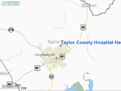
Taylor County Hospital Heliport |
|
Location &
QuickFacts
|
FAA
Information Effective: |
2008-09-25 |
|
Airport
Identifier: |
2KY7 |
|
Airport
Status: |
Operational |
|
Longitude/Latitude: |
085-20-16.0000W/37-22-00.0000N
-85.337778/37.366667 (Estimated) |
|
Elevation: |
872 ft / 265.79 m (Estimated) |
|
Land: |
0 acres |
|
From
nearest city: |
3 nautical miles NE of Campbellsville, KY |
|
Location: |
Taylor County, KY |
|
Magnetic Variation: |
03W (1995) |
Owner & Manager
|
Ownership: |
Privately owned |
|
Owner: |
Taylor County Hospital |
|
Address: |
1700 Old Taylor Road
Campbellsville, KY 42718 |
|
Phone
number: |
270-465-3561 |
|
Manager: |
David Gault |
|
Address: |
1700 Old Taylor Road
Campbellsville, KY 42718 |
|
Phone number: |
270-465-3561 |
Airport Operations and Facilities
|
Airport
Use: |
Private |
|
Wind
indicator: |
Yes |
|
Segmented Circle: |
No |
|
Control
Tower: |
No |
|
Lighting
Schedule: |
RDO-CTL
ACTVT NSTD GLOBE LGT BCN - 123.0. |
|
Sectional chart: |
Atlanta |
|
Region: |
ASO - Southern |
|
Boundary
ARTCC: |
ZID - Indianapolis |
|
Tie-in
FSS: |
LOU - Louisville |
|
FSS Toll
Free: |
1-800-WX-BRIEF |
|
Runway Information
Helipad H1
|
Dimension: |
40 x 40 ft / 12.2 x 12.2 m |
|
Surface: |
ASPH, |
|
|
Runway H1
|
Runway
|
|
Traffic
Pattern: |
Left |
Left |
|
Radio Navigation Aids
|
ID |
Type |
Name |
Ch |
Freq |
Var |
Dist |
|
TYC |
NDB |
Taylor County |
|
272.00 |
02W |
5.0 nm |
|
IKY |
NDB |
Springfield |
|
429.00 |
03W |
16.8 nm |
|
BRY |
NDB |
Bardstown/dcmsnd |
|
248.00 |
02W |
29.7 nm |
|
DVK |
NDB |
Goodall |
|
311.00 |
03W |
30.1 nm |
|
BVQ |
NDB |
Beaver Creek |
|
260.00 |
02W |
38.4 nm |
|
EKQ |
NDB |
Elk Spring |
|
290.00 |
03W |
38.5 nm |
|
CDX |
NDB |
Cumberland River |
|
388.00 |
05E |
38.5 nm |
|
GOI |
NDB |
Godman |
|
396.00 |
02W |
46.8 nm |
|
LE |
NDB |
Blayd |
|
242.00 |
04W |
49.3 nm |
|
EWO |
VOR/DME |
New Hope |
045X |
110.80 |
01E |
22.7 nm |
|
FTK |
VOR/DME |
Fort Knox |
033X |
109.60 |
01W |
44.4 nm |
|
IIU |
VORTAC |
Louisville |
095X |
114.80 |
01E |
45.7 nm |
|
LVT |
VORTAC |
Livingston |
021X |
108.40 |
02W |
47.7 nm |
Remarks
-
120 FT ANT 900 FT
SW OF HELIPAD.
-
HOSPITAL USES
FREQ 155.34 TO TRANSMIT & RECEIVE.
-
SEE ARISPACE CASE
95-MEM-102-NRA.
Taylor County Hospital Heliport
Address:
Taylor County, KY
Tel:
270-465-3561
Images
and information placed above are from
http://www.airport-data.com/airport/2KY7/
We
thank them for the data!
|
General Info |
| Country |
United
States |
| State |
KENTUCKY
|
| FAA ID |
2KY7
|
| Latitude |
37-22-00.000N |
|
Longitude |
085-20-16.000W |
|
Elevation |
872 feet
|
| Near
City |
CAMPBELLSVILLE |
We don't guarantee the information is fresh and accurate. The data may
be wrong or outdated.
For more up-to-date information please refer to other sources.
|
|


