 |
|
Sturgis Municipal Airport |
| Sturgis Municipal Airport |
| IATA: none â ICAO: KTWT â FAA LID: TWT |
| Summary |
| Airport type |
Public |
| Owner |
Union County Air Board |
| Serves |
Sturgis, Kentucky |
| Location |
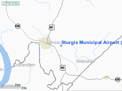
Union County, near Sturgis, Kentucky |
| Elevation AMSL |
372 ft / 113 m |
| Coordinates |
37°32â²30â³N 087°57â²16â³W / 37.54167°N 87.95444°W / 37.54167; -87.95444 |
| Website |
SturgisAirport.com |
| Runways |
| Direction |
Length |
Surface |
| ft |
m |
| 18/36 |
5,000 |
1,524 |
Asphalt |
| Statistics (2006) |
| Aircraft operations |
9,250 |
| Source: Federal Aviation Administration |
This article is about the airport in Kentucky.For other similarly named airports, see Sturgis Municipal Airport.
Sturgis Municipal Airport (ICAO: KTWT, FAA LID: TWT) is a public use airport located two nautical miles (4 km) east of the central business district of Sturgis, a city in Union County, Kentucky, United States. It is owned by the Union County Air Board. The airport was built in 1941 by the U.S. Army to provide pilot training during the World War II.
Although most U.S. airports use the same three-letter location identifier for the FAA and IATA, this airport is assigned TWT by the FAA but has no designation from the IATA (which assigned TWT to an airport in Tawitawi, Philippines).
Facilities and aircraft
Sturgis Municipal Airport covers an area of 1,307 acres (529 ha) at an elevation of 372 feet (113 m) above mean sea level. It has one asphalt paved runway designated 18/36 which measures 5,000 by 150 feet (1,524 x 46 m). For the 12-month period ending February 7, 2006, the airport had 9,250 aircraft operations, an average of 25 per day: 90% general aviation, 8% air taxi and 2% military.
The above content comes from Wikipedia and is published under free licenses – click here to read more.
|
Location &
QuickFacts
|
FAA
Information Effective: |
2008-09-25 |
|
Airport
Identifier: |
TWT |
|
Airport
Status: |
Operational |
|
Longitude/Latitude: |
087-57-15.7000W/37-32-30.4000N
-87.954361/37.541778 (Estimated) |
|
Elevation: |
372 ft / 113.39 m (Surveyed) |
|
Land: |
1307 acres |
|
From
nearest city: |
2 nautical miles E of Sturgis, KY |
|
Location: |
Union County, KY |
|
Magnetic Variation: |
00E (1985) |
Owner & Manager
|
Ownership: |
Publicly owned |
|
Owner: |
Union County Air Board |
|
Address: |
P.o. Box 381
Sturgis, KY 42459 |
|
Phone
number: |
270-333-4618
AIRPORT BOARD |
|
Manager: |
Ronnie Hollis |
|
Address: |
Municipal Arpt, Box 381
Sturgis, KY 42459 |
|
Phone number: |
270-333-4487 |
Airport Operations and Facilities
|
Airport
Use: |
Open to public |
|
Wind
indicator: |
Yes |
|
Segmented Circle: |
Yes |
|
Control
Tower: |
No |
|
Lighting
Schedule: |
DUSK-DAWN |
|
Beacon
Color: |
Clear-Green (lighted land airport) |
|
Landing
fee charge: |
No |
|
Sectional chart: |
St Louis |
|
Region: |
ASO - Southern |
|
Boundary
ARTCC: |
ZME - Memphis |
|
Responsible ARTCC: |
ZID - Indianapolis |
|
Tie-in
FSS: |
LOU - Louisville |
|
FSS on
Airport: |
No |
|
FSS Toll
Free: |
1-800-WX-BRIEF |
|
NOTAMs
Facility: |
LOU (NOTAM-d service avaliable) |
|
Federal Agreements: |
NGPY |
Airport Communications
|
CTAF: |
122.800 |
|
Unicom: |
122.800 |
Airport Services
|
Fuel
available: |
100LLA
FOR FUEL AFT 1600 CALL 270-836-6036. |
|
Airframe
Repair: |
NONE |
|
Power
Plant Repair: |
NONE |
|
Bottled
Oxygen: |
NONE |
|
Bulk
Oxygen: |
NONE |
|
Runway Information
Runway 18/36
|
Dimension: |
5000 x 150 ft / 1524.0 x 45.7 m |
|
Surface: |
ASPH, Good Condition |
|
Weight Limit: |
Single wheel: 30000 lbs.
Dual wheel: 50000 lbs. |
|
Edge Lights: |
Medium |
|
|
Runway 18
|
Runway 36
|
|
Longitude: |
087-57-13.9540W |
087-57-17.3683W |
|
Latitude: |
37-32-55.0280N |
37-32-05.6731N |
|
Elevation: |
370.00 ft |
372.00 ft |
|
Alignment: |
127 |
3 |
|
Traffic
Pattern: |
Left |
Left |
|
Markings: |
Non-precision instrument, Good Condition |
Non-precision instrument, Good Condition |
|
Crossing
Height: |
30.00 ft |
44.00 ft |
|
VASI: |
4-light PAPI on left side |
4-light PAPI on left side |
|
Visual
Glide Angle: |
3.50° |
3.00° |
|
Runway End
Identifier: |
Yes |
Yes |
|
Obstruction: |
, 50:1 slope to clear |
45 ft trees, 1700.0 ft from runway, 33:1 slope to clear |
|
Radio Navigation Aids
|
ID |
Type |
Name |
Ch |
Freq |
Var |
Dist |
|
TWT |
NDB |
Tradewater |
|
276.00 |
00E |
4.5 nm |
|
GVA |
NDB |
Geneva |
|
224.00 |
01W |
18.0 nm |
|
HSB |
NDB |
Harrisburg-raleigh |
|
230.00 |
00E |
32.5 nm |
|
CUL |
NDB |
Carmi |
|
332.00 |
01W |
34.1 nm |
|
PDW |
NDB |
Evansville |
|
284.00 |
00E |
36.1 nm |
|
BDD |
NDB |
Bellgrade |
|
254.00 |
00E |
41.7 nm |
|
GMH |
NDB |
Muhlenberg |
|
362.00 |
01E |
42.4 nm |
|
HIX |
NDB |
Honey Grove |
|
356.00 |
01W |
49.5 nm |
|
OWB |
VOR/DME |
Owensboro |
023X |
108.60 |
01E |
39.4 nm |
|
PXV |
VORTAC |
Pocket City |
080X |
113.30 |
03E |
25.0 nm |
|
CCT |
VORTAC |
Central City |
035X |
109.80 |
01W |
34.3 nm |
Remarks
-
PLINES RUNNING
BETWEEN T HANGARS.
-
VFR ONLY
Based Aircraft
|
Aircraft based
on field: |
9 |
|
Single Engine
Airplanes: |
7 |
|
Multi Engine
Airplanes: |
1 |
|
Jet Engine
Airplanes: |
1 |
Operational Statistics
Time Period: 2005-02-08 - 2006-02-07
|
Aircraft
Operations: |
178/Week |
|
Air Taxi: |
8.1% |
|
General
Aviation Local: |
42.2% |
|
General
Aviation Itinerant: |
47.6% |
|
Military: |
2.2% |
Sturgis Municipal Airport
Address:
Union County, KY
Tel:
270-333-4618,
270-333-4487
Images
and information placed above are from
http://www.airport-data.com/airport/TWT/
We
thank them for the data!
|
General Info |
| Country |
United
States |
| State |
KENTUCKY
|
| FAA ID |
TWT
|
| Time |
UTC-6(-5DT) |
| Latitude |
37.540833
37° 32' 27.00" N |
|
Longitude |
-87.951833
087° 57' 06.60" W |
|
Elevation |
372 feet
113 meters |
| Magnetic
Variation |
002° W
(01/06) |
| Beacon |
Yes
|
|
Operating Agency |
U.S.CIVIL AIRPORT WHEREIN PERMIT COVERS USE BY TRANSIT MILITARY
AIRCRAFT |
|
Operating Hours |
SEE
REMARKS FOR OPERATING HOURS OR COMMUNICATIONS FOR POSSIBLE HOURS
|
| Daylight
Saving Time |
Second
Sunday in March at 0200 to first Sunday in November at 0200 local time
(Exception Arizona and that portion of Indiana in the Eastern Time
Zone) |
We don't guarantee the information is fresh and accurate. The data may
be wrong or outdated.
For more up-to-date information please refer to other sources.
|
|


