|
|
Stuart Powell Field Airport |
| Stuart Powell Field |
| IATA: none â ICAO: KDVK â FAA LID: DVK |
| Summary |
| Airport type |
Public |
| Owner |
City of Danville & Boyle County |
| Serves |
Danville, Kentucky |
| Elevation AMSL |
1,022 ft / 312 m |
| Coordinates |
37°34â²40â³N 084°46â²11â³W / 37.57778°N 84.76972°W / 37.57778; -84.76972Coordinates: 37°34â²40â³N 084°46â²11â³W / 37.57778°N 84.76972°W / 37.57778; -84.76972 |
| Runways |
| Direction |
Length |
Surface |
| ft |
m |
| 12/30 |
5,000 |
1,524 |
Asphalt |
| 1/19 |
2,357 |
718 |
Asphalt |
| Statistics (2008) |
| Aircraft operations |
18,000 |
| Based aircraft |
43 |
| Source: Federal Aviation Administration |
Stuart Powell Field (ICAO: KDVK, FAA LID: DVK) is a public-use airport located 3 nautical miles (5.6 km) south of the central business district of Danville, a city in Boyle County, Kentucky, United States. It is owned by the City of Danville and Boyle County.
Although most U.S. airports use the same three-letter location identifier for the FAA and IATA, this airport is assigned DVK by the FAA but has no designation from the IATA.
Facilities and aircraft
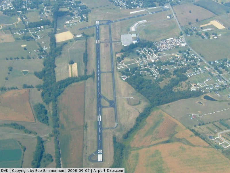
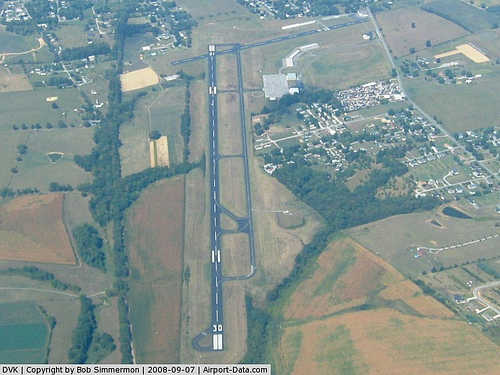
Stuart Powell Field covers an area of 170 acres (0.69 km) at an elevation of 1,022 feet (312 m) above mean sea level. It has two asphalt paved runways: 12/30 is 5,000 feet (1,524 m) by 75 feet (23 m) and 1/19 is 2,357 feet (718 m) by 75 feet (23 m).
For the 12-month period ending August 19, 2008, the airport had 18,000 aircraft operations, an average of 49 per day: 78% general aviation, 19% air taxi and 2% military. At that time there were 43 aircraft based at this airport: 74% single-engine, 16% multi-engine, 7% jet and 2% helicopter.
The above content comes from Wikipedia and is published under free licenses – click here to read more.
|
 |
(Click on the photo to enlarge) |
|
Location &
QuickFacts
|
FAA
Information Effective: |
2008-09-25 |
|
Airport
Identifier: |
DVK |
|
Airport
Status: |
Operational |
|
Longitude/Latitude: |
084-46-10.9000W/37-34-40.5000N
-84.769694/37.577917 (Estimated) |
|
Elevation: |
1022 ft / 311.51 m (Surveyed) |
|
Land: |
170 acres |
|
From
nearest city: |
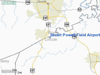
3 nautical miles S of Danville, KY |
|
Location: |
Boyle County, KY |
|
Magnetic Variation: |
03W (1995) |
Owner & Manager
|
Ownership: |
Publicly owned |
|
Owner: |
City Of Danville & Boyle County |
|
Address: |
City Hall
Danville, KY 40422-9424 |
|
Phone
number: |
859-236-8917
AIR BOARD CHAIRMAN STUART POWELL. |
|
Manager: |
Andrew Alliston |
|
Address: |
420 Airport Road
Danville, KY 40422-9424 |
|
Phone number: |
859-854-5994 |
Airport
Operations and Facilities
|
Airport
Use: |
Open to public |
|
Wind
indicator: |
Yes |
|
Segmented Circle: |
Yes |
|
Control
Tower: |
No |
|
Lighting
Schedule: |
DUSK-DAWN
ACTVT MIRL RY 12/30, PAPI RY 12/30, REIL RY 30 - CTAF. |
|
Beacon
Color: |
Clear-Green (lighted land airport) |
|
Landing
fee charge: |
No |
|
Sectional chart: |
Cincinnati |
|
Region: |
ASO - Southern |
|
Boundary
ARTCC: |
ZID - Indianapolis |
|
Tie-in
FSS: |
LOU - Louisville |
|
FSS on
Airport: |
No |
|
FSS Toll
Free: |
1-800-WX-BRIEF |
|
NOTAMs
Facility: |
LOU (NOTAM-d service avaliable) |
|
Federal Agreements: |
NGY |
Airport Communications
|
CTAF: |
122.800 |
|
Unicom: |
122.800 |
Airport Services
|
Fuel
available: |
100LLA |
|
Airframe
Repair: |
MINOR |
|
Power
Plant Repair: |
MINOR |
|
Bottled
Oxygen: |
NONE |
|
Bulk
Oxygen: |
NONE |
|
Runway Information
Runway 01/19
|
Dimension: |
2357 x 75 ft / 718.4 x 22.9 m |
|
Surface: |
ASPH, Good Condition |
|
Surface
Treatment: |
Rubberized Friction Seal Coat |
|
Weight Limit: |
Single wheel: 12000 lbs. |
|
|
Runway 01
|
Runway 19
|
|
Longitude: |
084-46-28.2370W |
084-46-24.1870W |
|
Latitude: |
37-34-41.6440N |
37-35-04.7230N |
|
Elevation: |
1014.00 ft |
1022.00 ft |
|
Alignment: |
8 |
127 |
|
Traffic
Pattern: |
Left |
Left |
|
Markings: |
Basic, Good Condition |
Basic, Good Condition |
|
Displaced
threshold: |
0.00 ft |
552.00 ft |
|
Obstruction: |
6 ft fence, 200.0 ft from runway |
30 ft hill, 250.0 ft from runway, 100 ft left of
centerline, 1:1 slope to clear
30 FT HILL 100 FT L, 20:1 BASED ON DSPLCD THR.
6' LINK FENCE AT END OF RWY. |
|
Runway 12/30
|
Dimension: |
5000 x 75 ft / 1524.0 x 22.9 m |
|
Surface: |
ASPH, Fair Condition |
|
Weight Limit: |
Single wheel: 30000 lbs. |
|
Edge Lights: |
Medium |
|
|
Runway 12
|
Runway 30
|
|
Longitude: |
084-46-30.2110W |
084-45-37.2780W |
|
Latitude: |
37-34-47.4590N |
37-34-21.6130N |
|
Elevation: |
1015.00 ft |
1016.00 ft |
|
Alignment: |
122 |
127 |
|
ILS Type: |
|
LOC/DME |
|
Traffic
Pattern: |
Left |
Left |
|
Markings: |
Non-precision instrument, Good Condition
AIM POINT MARKINGS 1200 FT FROM MARKED THLD. |
Non-precision instrument, Good Condition |
|
Crossing
Height: |
34.00 ft |
29.00 ft |
|
VASI: |
4-light PAPI on left side |
4-light PAPI on left side |
|
Visual
Glide Angle: |
3.50° |
3.00° |
|
Runway End
Identifier: |
|
Yes |
|
Obstruction: |
40 ft trees, 700.0 ft from runway, 251 ft right of
centerline, 12:1 slope to clear |
50 ft tree, 2203.0 ft from runway, 420 ft right of
centerline, 41:1 slope to clear |
|
Radio Navigation Aids
|
ID |
Type |
Name |
Ch |
Freq |
Var |
Dist |
|
DVK |
NDB |
Goodall |
|
311.00 |
03W |
0.3 nm |
|
IKY |
NDB |
Springfield |
|
429.00 |
03W |
22.5 nm |
|
TYC |
NDB |
Taylor County |
|
272.00 |
02W |
25.0 nm |
|
LE |
NDB |
Blayd |
|
242.00 |
04W |
25.1 nm |
|
CDX |
NDB |
Cumberland River |
|
388.00 |
05E |
35.2 nm |
|
XYC |
NDB |
Seco |
|
393.00 |
03W |
36.8 nm |
|
BRY |
NDB |
Bardstown/dcmsnd |
|
248.00 |
02W |
37.6 nm |
|
FEU |
NDB |
Arnold |
|
521.00 |
03W |
38.4 nm |
|
EKQ |
NDB |
Elk Spring |
|
290.00 |
03W |
43.6 nm |
|
IOB |
NDB |
Mount Sterling |
|
210.00 |
04W |
47.3 nm |
|
FFT |
VOR |
Frankfort |
|
109.40 |
03W |
36.9 nm |
|
EWO |
VOR/DME |
New Hope |
045X |
110.80 |
01E |
43.3 nm |
|
HYK |
VORTAC |
Lexington |
073X |
112.60 |
00E |
27.3 nm |
|
LOZ |
VORTAC |
London |
108X |
116.10 |
03W |
45.5 nm |
|
IIU |
VORTAC |
Louisville |
095X |
114.80 |
01E |
49.7 nm |
Remarks
-
AEROBATIC
PRACTICE AREA OVER SOUTH SIDE OF ARPT.
Based Aircraft
|
Aircraft based
on field: |
47 |
|
Single Engine
Airplanes: |
39 |
|
Multi Engine
Airplanes: |
4 |
|
Jet Engine
Airplanes: |
3 |
|
Helicopters: |
1 |
Operational Statistics
Time Period: 2005-02-28 - 2006-02-27
|
Aircraft
Operations: |
50/Day |
|
Air Taxi: |
19.4% |
|
General
Aviation Local: |
31.1% |
|
General
Aviation Itinerant: |
47.2% |
|
Military: |
2.2% |
Stuart Powell Field Airport
Address:
Boyle County, KY
Tel:
859-236-8917, 859-854-5994
Images
and information placed above are from
http://www.airport-data.com/airport/DVK/
We
thank them for the data!
|
General Info |
| Country |
United
States |
| State |
KENTUCKY
|
| FAA ID |
DVK
|
| Latitude |
37-34-40.500N |
|
Longitude |
084-46-10.900W |
|
Elevation |
1022
feet |
| Near
City |
DANVILLE
|
We don't guarantee the information is fresh and accurate. The data may
be wrong or outdated.
For more up-to-date information please refer to other sources.
|
|