 |
|
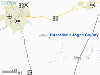
Russellville-logan County Airport |
|
|
|
Location &
QuickFacts
|
FAA
Information Effective: |
2008-09-25 |
|
Airport
Identifier: |
4M7 |
|
Airport
Status: |
Operational |
|
Longitude/Latitude: |
086-48-36.6000W/36-47-59.7000N
-86.810167/36.799917 (Estimated) |
|
Elevation: |
689 ft / 210.01 m (Surveyed) |
|
Land: |
68 acres |
|
From
nearest city: |
4 nautical miles SE of Russellville, KY |
|
Location: |
Logan County, KY |
|
Magnetic Variation: |
03E (1965) |
Owner & Manager
|
Ownership: |
Publicly owned |
|
Owner: |
City County Arpt Board
AIRPORT BOARD CHAIRMAN GARY L. HENDRICKS. |
|
Address: |
1269 Jim Soyars Road
Russellville, KY 42276 |
|
Phone number: |
270-726-8036 |
|
Manager: |
Steve Wilson |
|
Address: |
385 Airport Rd.
Russellville, KY 42276 |
|
Phone number: |
270-726-3214 |
Airport
Operations and Facilities
|
Airport
Use: |
Open to public |
|
Wind
indicator: |
Yes |
|
Segmented Circle: |
Yes |
|
Control
Tower: |
No |
|
Lighting
Schedule: |
DUSK-DAWN
ACTVT VASI RYS 06 & 24 - CTAF. DUSK-DAWN ACTVT MIRL RY 06/24 - CTAF. |
|
Beacon
Color: |
Clear-Green (lighted land airport) |
|
Landing
fee charge: |
No |
|
Sectional chart: |
St Louis |
|
Region: |
ASO - Southern |
|
Boundary
ARTCC: |
ZME - Memphis |
|
Tie-in
FSS: |
LOU - Louisville |
|
FSS on
Airport: |
No |
|
FSS Toll
Free: |
1-800-WX-BRIEF |
|
NOTAMs
Facility: |
LOU (NOTAM-d service avaliable) |
|
Federal Agreements: |
NGY |
Airport Communications
|
CTAF: |
122.700 |
|
Unicom: |
122.700 |
Airport Services
|
Fuel
available: |
100LL |
|
Airframe
Repair: |
MINOR |
|
Power
Plant Repair: |
MINOR |
|
Bottled
Oxygen: |
NONE |
|
Bulk
Oxygen: |
NONE |
|
Runway Information
Runway 06/24
|
Dimension: |
3999 x 75 ft / 1218.9 x 22.9 m |
|
Surface: |
ASPH, Good Condition |
|
Weight Limit: |
Single wheel: 12500 lbs. |
|
Edge Lights: |
Medium |
|
|
Runway 06
|
Runway 24
|
|
Longitude: |
086-48-58.5490W |
086-48-14.5520W |
|
Latitude: |
36-47-50.8470N |
36-48-08.5050N |
|
Elevation: |
689.00 ft |
655.00 ft |
|
Alignment: |
63 |
127 |
|
Traffic
Pattern: |
Left |
Left |
|
Markings: |
Non-precision instrument, Good Condition |
Non-precision instrument, Good Condition |
|
Crossing
Height: |
25.00 ft |
25.00 ft |
|
VASI: |
2-box on left side |
2-box on left side |
|
Visual
Glide Angle: |
3.00° |
3.00° |
|
Runway End
Identifier: |
Yes
AND 24 REILS OTS INDEFLY. |
Yes |
|
Obstruction: |
25 ft trees, 1085.0 ft from runway, 147 ft right of
centerline, 36:1 slope to clear
+8 FT ROAD 150 FT FROM RY END AND 240 FT LEFT. |
43 ft trees, 491.0 ft from runway, 257 ft right of
centerline, 8:1 slope to clear |
|
Radio Navigation Aids
|
ID |
Type |
Name |
Ch |
Freq |
Var |
Dist |
|
PED |
NDB |
Needmore |
|
221.00 |
01W |
16.7 nm |
|
ON |
NDB |
Music |
|
279.00 |
03W |
22.9 nm |
|
HIX |
NDB |
Honey Grove |
|
356.00 |
01W |
25.8 nm |
|
FK |
NDB |
Airbe |
|
273.00 |
01W |
29.3 nm |
|
GMH |
NDB |
Muhlenberg |
|
362.00 |
01E |
30.7 nm |
|
VI |
NDB |
Opery |
|
344.00 |
02W |
36.6 nm |
|
LFB |
NDB |
Lafayette |
|
245.00 |
02W |
40.0 nm |
|
BVQ |
NDB |
Beaver Creek |
|
260.00 |
02W |
40.7 nm |
|
JUE |
NDB |
Lebanon |
|
414.00 |
02W |
43.7 nm |
|
HXW |
TACAN |
Screaming Eagle |
096X |
|
01W |
33.8 nm |
|
CKV |
VOR/DME |
Clarksville |
043X |
110.60 |
01W |
30.9 nm |
|
BWG |
VORTAC |
Bowling Green |
126X |
117.90 |
02E |
19.3 nm |
|
BNA |
VORTAC |
Nashville |
088X |
114.10 |
02W |
40.3 nm |
|
CCT |
VORTAC |
Central City |
035X |
109.80 |
01W |
41.2 nm |
|
BNA |
VOT |
Nashville Metropoln |
|
108.60 |
|
40.9 nm |
|
MQY |
VOT |
Smyrna |
|
110.20 |
|
49.9 nm |
Remarks
-
ULTRALGT ACTVTY
ON & INVOF ARPT.
Based Aircraft
|
Aircraft based
on field: |
19 |
|
Single Engine
Airplanes: |
15 |
|
Multi Engine
Airplanes: |
2 |
|
Ultralights: |
2 |
Operational Statistics
Time Period: 2005-02-08 - 2006-02-07
|
Aircraft
Operations: |
218/Week |
|
Air Taxi: |
5.3% |
|
General
Aviation Local: |
42.5% |
|
General
Aviation Itinerant: |
50.4% |
|
Military: |
1.8% |
Russellville-logan County Airport
Address:
Logan County, KY
Tel:
270-726-8036, 270-726-3214
Images
and information placed above are from
http://www.airport-data.com/airport/4M7/
We
thank them for the data!
|
General Info |
| Country |
United
States |
| State |
KENTUCKY
|
| FAA ID |
4M7
|
| Latitude |
36-47-59.700N |
|
Longitude |
086-48-36.600W |
|
Elevation |
689 feet
|
| Near
City |
RUSSELLVILLE |
We don't guarantee the information is fresh and accurate. The data may
be wrong or outdated.
For more up-to-date information please refer to other sources.
|
|


