 |
|
Pike County - Hatcher Field Airport |
Pike County Airport
Hatcher Field |
 |
| IATA: none â ICAO: KPBX â FAA LID: PBX |
| Summary |
| Airport type |
Public |
| Owner |
Pike County Regional Airport Board |
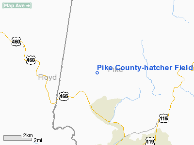
| Serves |
Pikeville, Kentucky |
| Elevation AMSL |
1,473 ft / 449 m |
| Coordinates |
37°33â²42â³N 082°33â²59â³W / 37.56167°N 82.56639°W / 37.56167; -82.56639 |
| Runways |
| Direction |
Length |
Surface |
| ft |
m |
| 9/27 |
5,350 |
1,631 |
Asphalt |
2/20
(closed) |
3,600 |
1,097 |
Asphalt |
| Statistics (2009) |
| Aircraft operations |
8,722 |
| Based aircraft |
23 |
| Source: Federal Aviation Administration |
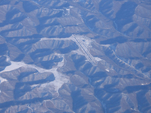
Pike County Airport (ICAO: KPBX, FAA LID: PBX), also known as Hatcher Field, is a public-use airport in Pike County, Kentucky, United States. It is owned by the Pike County Regional Airport Board and located six nautical miles (11 km) northwest of the central business district of Pikeville, Kentucky. This airport is included in the FAA's National Plan of Integrated Airport Systems for 2009â2013, which categorized it as a general aviation facility.
Although many U.S. airports use the same three-letter location identifier for the FAA and IATA, this facility is assigned PBX by the FAA but has no designation from the IATA.
Facilities and aircraft
Pike County-Hatcher Field covers an area of 46 acres (19 ha) at an elevation of 1,473 feet (449 m) above mean sea level. It has two asphalt paved runways: 9/27 is 5,350 by 100 feet (1,631 x 30 m) and 2/20 is 3,600 by 75 feet (1,097 x 23 m). Only runway 9/27 is open for aircraft operations; runway 2/20 is closed indefinitely.
For the 12-month period ending September 30, 2009, the airport had 8,722 aircraft operations, an average of 23 per day: 87% general aviation, 11% air taxi, and 2% military. At that time there were 23 aircraft based at this airport: 83% single-engine and 17% multi-engine.
The above content comes from Wikipedia and is published under free licenses – click here to read more.
|
Location &
QuickFacts
|
FAA
Information Effective: |
2008-09-25 |
|
Airport
Identifier: |
PBX |
|
Airport
Status: |
Operational |
|
Longitude/Latitude: |
082-33-59.0000W/37-33-42.3500N
-82.566389/37.561764 (Estimated) |
|
Elevation: |
1473 ft / 448.97 m (Surveyed) |
|
Land: |
46 acres |
|
From
nearest city: |
6 nautical miles NW of Pikeville, KY |
|
Location: |
Pike County, KY |
|
Magnetic Variation: |
06W (2000) |
Owner & Manager
|
Ownership: |
Publicly owned |
|
Owner: |
Pike County Reg Arpt Board |
|
Address: |
Box 339
Pikeville, KY 41502 |
|
Phone
number: |
606-437-7366
COUNTY ARPT BOARD CHAIRMAN MICHAEL DE BOURBON. |
|
Manager: |
Airport Board |
|
Address: |
P.o. Box 3353
Pikeville, KY 41501 |
|
Phone number: |
606-437-9548 |
Airport Operations and Facilities
|
Airport
Use: |
Open to public |
|
Wind
indicator: |
Yes |
|
Segmented Circle: |
Yes |
|
Control
Tower: |
No |
|
Lighting
Schedule: |
DUSK-DAWN
ACTVT MIRL RYS 02/20 & 09/27, REIL RYS 02, 20, 09 & 27, VASI RYS 02 &
20 AND PAPI RYS 09 & 27 - CTAF. |
|
Beacon
Color: |
Clear-Green (lighted land airport) |
|
Sectional chart: |
Cincinnati |
|
Region: |
ASO - Southern |
|
Boundary
ARTCC: |
ZID - Indianapolis |
|
Tie-in
FSS: |
LOU - Louisville |
|
FSS Toll
Free: |
1-800-WX-BRIEF |
|
NOTAMs
Facility: |
LOU (NOTAM-d service avaliable) |
|
Federal Agreements: |
N |
Airport Communications
|
CTAF: |
122.800 |
|
Unicom: |
122.800 |
Airport Services
|
Fuel
available: |
100LLA |
|
Airframe
Repair: |
MAJOR |
|
Power
Plant Repair: |
MAJOR |
|
Bottled
Oxygen: |
NONE |
|
Bulk
Oxygen: |
NONE |
|
Runway Information
Runway 02/20
|
Dimension: |
3600 x 75 ft / 1097.3 x 22.9 m |
|
Surface: |
ASPH, Fair Condition |
|
Weight Limit: |
Single wheel: 12000 lbs. |
|
Edge Lights: |
Medium
MIRL OTS INDEFLY. |
|
|
Runway 02
|
Runway 20
|
|
Longitude: |
082-33-45.4900W |
082-33-33.1700W |
|
Latitude: |
37-33-30.8400N |
37-34-05.0600N |
|
Elevation: |
1472.00 ft |
1457.00 ft |
|
Alignment: |
16 |
127 |
|
Traffic
Pattern: |
Left |
Left |
|
Markings: |
Basic, Poor Condition
RY 02/20 MARKINGS FADED AND OBSCURED. |
Basic, Poor Condition |
|
Crossing
Height: |
26.00 ft |
29.00 ft |
|
VASI: |
2-box on left side |
2-box on left side
VASI OTS INDEF. |
|
Visual
Glide Angle: |
3.00° |
3.00° |
|
Runway End
Identifier: |
Yes |
Yes
REIL OTS INDEF. |
|
Obstruction: |
, 50:1 slope to clear |
20 ft trees, 201.0 ft from runway, 100 ft left of
centerline
+20 FT TREES 30 FT FM THLD 30 FT L. |
|
Runway 09/27
|
Dimension: |
5350 x 100 ft / 1630.7 x 30.5 m |
|
Surface: |
ASPH, Good Condition |
|
Weight Limit: |
Single wheel: 30000 lbs. |
|
Edge Lights: |
Medium
MIRL OTS INDEFLY. |
|
|
Runway 09
|
Runway 27
|
|
Longitude: |
082-34-45.4200W |
082-33-39.0700W |
|
Latitude: |
37-33-37.1600N |
37-33-39.9900N |
|
Elevation: |
1450.00 ft |
1466.00 ft |
|
Alignment: |
87 |
127 |
|
ILS Type: |
|
ILS/DME |
|
Traffic
Pattern: |
Left |
Left |
|
Markings: |
Precision instrument, Good Condition |
Precision instrument, Good Condition |
|
Crossing
Height: |
33.00 ft |
47.00 ft |
|
Displaced
threshold: |
350.00 ft |
350.00 ft |
|
VASI: |
4-light PAPI on left side |
4-light PAPI on left side |
|
Visual
Glide Angle: |
3.00° |
3.00° |
|
Runway End
Identifier: |
Yes |
Yes |
|
Obstruction: |
35 ft trees, 220.0 ft from runway, 300 ft left of
centerline
APCH RATIO 2:1 TO DSPLCD THLD, 20 FT TREES 50 FT FROM DSPLCD THLD 250 FT
L.
+15 FT TREES 195 FT FROM THLD, 400 FT R. |
10 ft fence, 230.0 ft from runway, 490 ft left of
centerline, 3:1 slope to clear
APCH RATIO 39:1 TO DSPLCD THLD, +65 FT TREES 2550 FT FROM DSPCD THLD 650
FT R.
5 FT BERM 200 FT RY 490 FT L. |
|
Decleard
distances: |
Take off run available 5350.00 ft
Take off distance available 5350.00 ft
Actual stop distance available 5000.00 ft
Landing distance available 4650.00 ft |
Take off run available 5350.00 ft
Take off distance available 5350.00 ft
Actual stop distance available 5000.00 ft
Landing distance available 4650.00 ft |
|
Radio Navigation Aids
|
ID |
Type |
Name |
Ch |
Freq |
Var |
Dist |
|
GTC |
NDB |
Guyandot |
|
293.00 |
03W |
34.0 nm |
|
AZQ |
VOR/DME |
Hazard |
049X |
111.20 |
04W |
34.8 nm |
|
ECB |
VORTAC |
Newcombe |
041X |
110.40 |
02W |
39.4 nm |
Remarks
Based Aircraft
|
Aircraft based
on field: |
23 |
|
Single Engine
Airplanes: |
19 |
|
Multi Engine
Airplanes: |
4 |
Operational Statistics
Time Period: 2006-06-13 - 2007-06-12
|
Aircraft
Operations: |
172/Week |
|
Air Taxi: |
11.2% |
|
General
Aviation Local: |
28.1% |
|
General
Aviation Itinerant: |
58.4% |
|
Military: |
2.2% |
Pike County-hatcher Field Airport
Address:
Pike County, KY
Tel:
606-437-7366, 606-437-9548
Images
and information placed above are from
http://www.airport-data.com/airport/PBX/
We
thank them for the data!
|
General Info |
| Country |
United
States |
| State |
KENTUCKY
|
| FAA ID |
PBX
|
| Latitude |
37-33-42.346N |
|
Longitude |
082-33-59.004W |
|
Elevation |
1473
feet |
| Near
City |
PIKEVILLE |
We don't guarantee the information is fresh and accurate. The data may
be wrong or outdated.
For more up-to-date information please refer to other sources.
|
|


