 |
|
|
Location &
QuickFacts
|
FAA
Information Effective: |
2008-09-25 |
|
Airport
Identifier: |
2KY4 |
|
Airport
Status: |
Operational |
|
Longitude/Latitude: |
085-48-49.0000W/37-39-18.0000N
-85.813611/37.655000 (Estimated) |
|
Elevation: |
820 ft / 249.94 m (Estimated) |
|
Land: |
0 acres |
|
From
nearest city: |
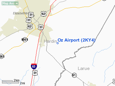
6 nautical miles E of Elizabethtown, KY |
|
Location: |
Hardin County, KY |
|
Magnetic Variation: |
03W (1995) |
Owner & Manager
|
Ownership: |
Privately owned |
|
Owner: |
James Livers |
|
Address: |
601 Thoroughbred Lane
Elizabethtown, KY 42701 |
|
Phone number: |
270-737-1049 |
|
Manager: |
James Livers |
|
Address: |
601 Thoroughbred Lane
Elizabethtown, KY 42701 |
|
Phone number: |
270-737-1049 |
Airport
Operations and Facilities
|
Airport
Use: |
Private |
|
Wind
indicator: |
Yes |
|
Segmented Circle: |
No |
|
Control
Tower: |
No |
|
Sectional chart: |
St Louis |
|
Region: |
ASO - Southern |
|
Boundary
ARTCC: |
ZID - Indianapolis |
|
Tie-in
FSS: |
LOU - Louisville |
|
FSS Toll
Free: |
1-800-WX-BRIEF |
|
Runway Information
Runway 14/32
|
Dimension: |
2930 x 85 ft / 893.1 x 25.9 m |
|
Surface: |
TURF, |
|
|
Runway 14
|
Runway 32
|
|
Traffic
Pattern: |
Left |
Left |
|
Markings: |
Nonstandard,
RY 14/32 HAS WHITE MARKERS AT RY ENDS. |
Nonstandard, |
|
Radio Navigation Aids
|
ID |
Type |
Name |
Ch |
Freq |
Var |
Dist |
|
BRY |
NDB |
Bardstown/dcmsnd |
|
248.00 |
02W |
19.5 nm |
|
GOI |
NDB |
Godman |
|
396.00 |
02W |
19.8 nm |
|
IKY |
NDB |
Springfield |
|
429.00 |
03W |
27.5 nm |
|
TYC |
NDB |
Taylor County |
|
272.00 |
02W |
31.1 nm |
|
BVQ |
NDB |
Beaver Creek |
|
260.00 |
02W |
39.4 nm |
|
TEL |
NDB |
Tell City |
|
206.00 |
02W |
46.9 nm |
|
MYS |
VOR |
Mystic |
|
108.20 |
01W |
25.0 nm |
|
EWO |
VOR/DME |
New Hope |
045X |
110.80 |
01E |
6.7 nm |
|
FTK |
VOR/DME |
Fort Knox |
033X |
109.60 |
01W |
17.0 nm |
|
BQM |
VOR/DME |
Bowman |
059X |
112.20 |
01W |
35.3 nm |
|
IIU |
VORTAC |
Louisville |
095X |
114.80 |
01E |
29.2 nm |
|
SDF |
VOT |
Louisville Standifd |
|
111.00 |
|
31.6 nm |
Remarks
-
THREE RADIO
TOWERS 320 FT TO 650 FT MSL LCTD 2 NM NORTHWEST OF ARPT.
-
OWNER DESIRES
ARPT NOT BE CHARTED.
-
PRVDD VFR, PVT
USE, LNDG AREA MEETS ALL CRITERIA OF FAA AC 150/5300-13, LETTER OF AGREEMENT
WITH ELIZABETHTOWN ADDINGTON FIELD ARPT & HORNBACK ARPT.
Based Aircraft
|
Aircraft based
on field: |
2 |
|
Single Engine
Airplanes: |
1 |
|
Ultralights: |
1 |
Oz Airport
Address:
Hardin County, KY
Tel:
270-737-1049
Images
and information placed above are from
http://www.airport-data.com/airport/2KY4/
We
thank them for the data!
|
General Info |
| Country |
United
States |
| State |
KENTUCKY
|
| FAA ID |
2KY4
|
| Latitude |
37-39-18.000N |
|
Longitude |
085-48-49.000W |
|
Elevation |
820 feet
|
| Near
City |
ELIZABETHTOWN |
We don't guarantee the information is fresh and accurate. The data may
be wrong or outdated.
For more up-to-date information please refer to other sources.
|
|


