 |
|
Owensboro-Daviess County Airport |
Coordinates: 37°44â²20â³N 087°10â²01â³W / 37.73889°N 87.16694°W / 37.73889; -87.16694
| Owensboro-Daviess County Airport |
| IATA: OWB â ICAO: KOWB â FAA LID: OWB |
| Summary |
| Airport type |
Public |
| Owner |
Owensboro City & Daviess County |
| Serves |
Owensboro, Kentucky |
| Elevation AMSL |
406 ft / 124 m |
| Website |
www.owb.net |
| Runways |
| Direction |
Length |
Surface |
| ft |
m |
| 18/36 |
8,000 |
2,438 |
Asphalt/Concrete |
| 5/23 |
5,000 |
1,524 |
Asphalt/Concrete |
| Statistics (2007) |
| Aircraft operations |
60,688 |
| Based aircraft |
47 |
| Source: Federal Aviation Administration |
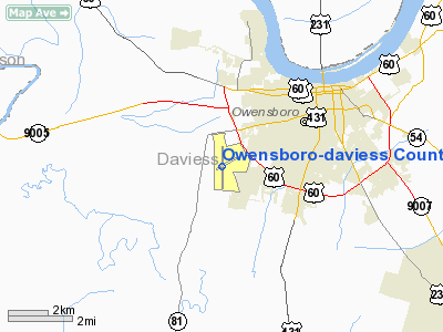
Owensboro-Daviess County Airport (IATA: OWB, ICAO: KOWB, FAA LID: OWB) is a public airport located three miles (5 km) southwest of the central business district of Owensboro, a city in Daviess County, Kentucky, United States. It is owned by both the city and county. The airport is mostly used for general aviation and is served by one commercial airline.
As per Federal Aviation Administration records, the airport had 4,680 passenger boardings (enplanements) in calendar year 2006, up from 3,611 enplanements in 2005. According to the FAA's National Plan of Integrated Airport Systems for 2007â2011, it was classified as commercial service - non-primary because it had between 2,500 and 10,000 passenger boardings per year.
Scheduled commercial service was subsidized by the Essential Air Service program. RegionsAir provided flights to St. Louis until it ceased operations in March 2007. The next EAS contract was awarded to Big Sky Airlines, operating as Delta Connection, with service to Cincinnati scheduled to begin in June 2007. Big Sky began service in November 2007 and abruptly ended operations here in January 2008. Great Lakes Aviation was awarded a contract but ultimately cancelled. On February 19, 2009, Allegiant Air began service from Owensboro to Orlando Sanford International Airport. Pacific Wings has been awarded the most recent Essential Air Service contract to Nashville. Facilities and aircraft
Owensboro-Daviess County Airport covers an area of 826 acres (334 ha) which contains two asphalt and concrete paved runways: 18/36 measuring 8,000 x 150 ft (2,438 x 46 m) and 5/23 measuring 5,000 x 100 ft (1,524 x 30 m).
For the 12-month period ending March 31, 2007, the airport had 60,688 aircraft operations, an average of 166 per day: 90% general aviation, 5% military, 5% air taxi and <1% scheduled commercial. There are 50 aircraft based at this airport: 74% single-engine (37), 12% multi-engine (6), 12% jet and 2% ultralight.
Airlines and destinations
| Airlines |
Destinations |
| Allegiant Air |
Orlando-Sanford |
| KentuckySkies operated by Pacific Wings |
Nashville |
The above content comes from Wikipedia and is published under free licenses – click here to read more.
|
Location &
QuickFacts
|
FAA
Information Effective: |
2008-09-25 |
|
Airport
Identifier: |
OWB |
|
Airport
Status: |
Operational |
|
Longitude/Latitude: |
087-10-00.5828W/37-44-19.8030N
-87.166829/37.738834 (Estimated) |
|
Elevation: |
407 ft / 124.05 m (Surveyed) |
|
Land: |
826 acres |
|
From
nearest city: |
3 nautical miles SW of Owensboro, KY |
|
Location: |
Daviess County, KY |
|
Magnetic Variation: |
01W (1985) |
Owner & Manager
|
Ownership: |
Publicly owned |
|
Owner: |
Owensboro City & Daviess County |
|
Address: |
2200 Airport Road
Owensboro, KY 42303 |
|
Phone number: |
270-685-4179 |
|
Manager: |
George Smith |
|
Address: |
2200 Airport Road
Owensboro, KY 42303 |
|
Phone number: |
270-685-4179 |
Airport
Operations and Facilities
|
Airport
Use: |
Open to public |
|
Wind
indicator: |
Yes |
|
Segmented Circle: |
Yes |
|
Control
Tower: |
Yes |
|
Lighting
Schedule: |
DUSK-DAWN
WHEN ATCT CLSD ACTVT HIRL RY 18/36, MIRL RY 05/23, MALSR 36, REILS RY
05/23 & RY 18, PAPI RYS 05 & 23, VASI RY 36, TWY & WINDCONE LGTS -
CTAF. |
|
Beacon
Color: |
Clear-Green (lighted land airport) |
|
Landing
fee charge: |
No |
|
Sectional chart: |
St Louis |
|
Region: |
ASO - Southern |
|
Boundary
ARTCC: |
ZID - Indianapolis |
|
Tie-in
FSS: |
LOU - Louisville |
|
FSS on
Airport: |
No |
|
FSS Toll
Free: |
1-800-WX-BRIEF |
|
NOTAMs
Facility: |
OWB (NOTAM-d service avaliable) |
|
Certification type/date: |
I A S 04/1989
PPR 24 HRS FOR UNSKED ACR OPNS WITH MORE THAN 30 PSGR SEATS CALL AMGR
270-685-4179. |
|
Federal Agreements: |
NGY |
Airport Communications
|
CTAF: |
120.700 |
|
Unicom: |
122.950 |
Airport Services
|
Fuel
available: |
100LLA |
|
Airframe
Repair: |
MAJOR |
|
Power
Plant Repair: |
MAJOR |
|
Bottled
Oxygen: |
LOW |
|
Bulk
Oxygen: |
NONE |
|
Runway Information
Runway 05/23
|
Dimension: |
5000 x 100 ft / 1524.0 x 30.5 m |
|
Surface: |
ASPH-CONC, Fair Condition
FIRST 2000 FT OF RY 18 CONC-EXCELLENT.
LAST 4494 FT
ASPH-FAIR. |
|
Weight Limit: |
Single wheel: 40000 lbs.
Dual wheel: 40000 lbs.
Dual tandem wheel: 40000 lbs. |
|
Edge Lights: |
Medium |
|
|
Runway 05
|
Runway 23
|
|
Longitude: |
087-10-22.8653W |
087-09-33.8292W |
|
Latitude: |
37-44-09.7270N |
37-44-40.1777N |
|
Elevation: |
405.00 ft |
403.00 ft |
|
Alignment: |
52 |
127 |
|
Traffic
Pattern: |
Left |
Left |
|
Markings: |
Non-precision instrument, Good Condition |
Non-precision instrument, Good Condition |
|
Crossing
Height: |
45.00 ft |
45.00 ft |
|
VASI: |
2-light PAPI on left side |
2-light PAPI on left side |
|
Visual
Glide Angle: |
3.00° |
3.00° |
|
Runway End
Identifier: |
Yes |
Yes |
|
Runway 18/36
|
Dimension: |
8000 x 150 ft / 2438.4 x 45.7 m |
|
Surface: |
ASPH-CONC, Fair Condition
FIRST 2000 FT OF RY 18 CONC-EXCELLENT.
LAST 4494 FT
ASPH-FAIR. |
|
Weight Limit: |
Single wheel: 75000 lbs.
Dual wheel: 150000 lbs.
Dual tandem wheel: 200000 lbs. |
|
Edge Lights: |
High |
|
|
Runway 18
|
Runway 36
|
|
Longitude: |
087-10-03.9573W |
087-10-00.0008W |
|
Latitude: |
37-44-56.0968N |
37-43-37.0736N |
|
Elevation: |
407.00 ft |
397.00 ft |
|
Alignment: |
127 |
127 |
|
ILS Type: |
|
ILS |
|
Traffic
Pattern: |
Left |
Left |
|
Markings: |
Precision instrument, Good Condition |
Precision instrument, Good Condition |
|
Crossing
Height: |
52.00 ft |
56.00 ft |
|
Displaced
threshold: |
0.00 ft |
1500.00 ft |
|
VASI: |
4-box on left side |
4-box on left side |
|
Visual
Glide Angle: |
3.00° |
3.00° |
|
Approach
lights: |
|
MALSR |
|
Runway End
Identifier: |
Yes |
|
|
Decleard
distances: |
Take off run available 7000.00 ft
Take off distance available 7000.00 ft
Actual stop distance available 8000.00 ft
Landing distance available 8000.00 ft |
Take off run available 8000.00 ft
Take off distance available 8000.00 ft
Actual stop distance available 8000.00 ft
Landing distance available 6500.00 ft |
|
Radio Navigation Aids
|
ID |
Type |
Name |
Ch |
Freq |
Var |
Dist |
|
PDW |
NDB |
Evansville |
|
284.00 |
00E |
25.0 nm |
|
TEL |
NDB |
Tell City |
|
206.00 |
02W |
28.0 nm |
|
GVA |
NDB |
Geneva |
|
224.00 |
01W |
29.0 nm |
|
GMH |
NDB |
Muhlenberg |
|
362.00 |
01E |
30.8 nm |
|
FNZ |
NDB |
Ferdinand |
|
239.00 |
00E |
34.4 nm |
|
TWT |
NDB |
Tradewater |
|
276.00 |
00E |
40.6 nm |
|
CUL |
NDB |
Carmi |
|
332.00 |
01W |
50.0 nm |
|
MYS |
VOR |
Mystic |
|
108.20 |
01W |
44.8 nm |
|
OWB |
VOR/DME |
Owensboro |
023X |
108.60 |
01E |
0.3 nm |
|
HNB |
VOR/DME |
Huntingburg |
029X |
109.20 |
00E |
32.3 nm |
|
CCT |
VORTAC |
Central City |
035X |
109.80 |
01W |
21.9 nm |
|
PXV |
VORTAC |
Pocket City |
080X |
113.30 |
03E |
30.5 nm |
Remarks
-
COYOTES ON &
INVOF ALL RYS & TWYS.
-
LARGE FLOCKS OF
BIRDS ON & INVOF ARPT.
-
EXISTED PRIOR TO 1959.
Based Aircraft
|
Aircraft based
on field: |
49 |
|
Single Engine
Airplanes: |
33 |
|
Multi Engine
Airplanes: |
8 |
|
Jet Engine
Airplanes: |
6 |
|
Helicopters: |
1 |
|
Ultralights: |
1 |
Operational Statistics
Time Period: 2007-04-02 - 2008-03-31
|
Aircraft
Operations: |
167/Day |
|
Commerical: |
0.9% |
|
Air Taxi: |
4.6% |
|
General
Aviation Local: |
40.0% |
|
General
Aviation Itinerant: |
49.6% |
|
Military: |
4.9% |
Owensboro-daviess County Airport
Address:
Daviess County, KY
Tel:
270-685-4179
Images
and information placed above are from
http://www.airport-data.com/airport/OWB/
We
thank them for the data!
|
General Info |
| Country |
United
States |
| State |
KENTUCKY
|
| FAA ID |
OWB
|
| Latitude |
37-44-24.400N |
|
Longitude |
087-10-00.600W |
|
Elevation |
406 feet
|
| Near
City |
OWENSBORO |
We don't guarantee the information is fresh and accurate. The data may
be wrong or outdated.
For more up-to-date information please refer to other sources.
|
|


