 |
|
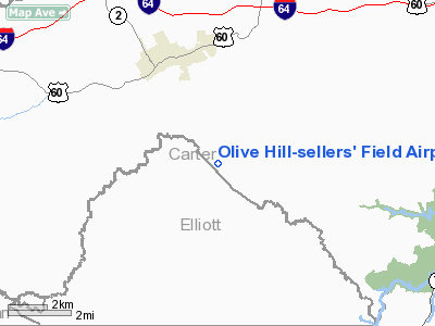
Olive Hill-sellers' Field Airport |
|
|
|
Location &
QuickFacts
|
FAA
Information Effective: |
2008-09-25 |
|
Airport
Identifier: |
2I2 |
|
Airport
Status: |
Operational |
|
Longitude/Latitude: |
083-08-34.6290W/38-15-13.2930N
-83.142953/38.253692 (Estimated) |
|
Elevation: |
1016 ft / 309.68 m (Estimated) |
|
Land: |
31 acres |
|
From
nearest city: |
3 nautical miles SE of Olive Hill, KY |
|
Location: |
Carter County, KY |
|
Magnetic Variation: |
04W (1985) |
Owner & Manager
|
Ownership: |
Publicly owned |
|
Owner: |
City Of Olive Hill |
|
Address: |
Po Box 1660
Olive Hill, KY 41164 |
|
Phone
number: |
606-286-5532 |
|
Manager: |
Gayle Smith
AIRBOARD CHAIRMAN. |
|
Address: |
813 Old Us Hgy 60
Olive Hill, KY 41164 |
|
Phone number: |
606-286-5220 |
Airport Operations and Facilities
|
Airport
Use: |
Open to public |
|
Wind
indicator: |
No |
|
Segmented Circle: |
No |
|
Control
Tower: |
No |
|
Landing
fee charge: |
No |
|
Sectional chart: |
Cincinnati |
|
Region: |
ASO - Southern |
|
Boundary
ARTCC: |
ZID - Indianapolis |
|
Tie-in
FSS: |
LOU - Louisville |
|
FSS on
Airport: |
No |
|
FSS Toll
Free: |
1-800-WX-BRIEF |
|
NOTAMs
Facility: |
LOU (NOTAM-d service avaliable) |
Airport Communications
Airport Services
|
Airframe
Repair: |
NONE |
|
Power
Plant Repair: |
NONE |
|
Bottled
Oxygen: |
NONE |
|
Bulk
Oxygen: |
NONE |
|
Runway Information
Runway 02/20
|
Dimension: |
2500 x 50 ft / 762.0 x 15.2 m |
|
Surface: |
ASPH,
RUNWAY HAS WIDESPREAD SEVERE CRACKING WITH RAVELING AND DETERIORATION. |
|
|
Runway 02
|
Runway 20
|
|
Traffic
Pattern: |
Left |
Left |
|
Markings: |
Basic, Good Condition |
Basic, Good Condition |
|
Runway End
Identifier: |
No |
No |
|
Centerline
Lights: |
No |
No |
|
Touchdown
Lights: |
No |
No |
|
Obstruction: |
15 ft trees, 400.0 ft from runway, 100 ft right of
centerline, 13:1 slope to clear |
35 ft trees, 250.0 ft from runway, 125 ft right of
centerline, 1:1 slope to clear
+40 FT HILL 0-150 FT FM RY END 90 FT RIGHT. |
|
Radio Navigation Aids
|
ID |
Type |
Name |
Ch |
Freq |
Var |
Dist |
|
AJY |
FAN MARKER |
Ashland |
|
|
03W |
24.5 nm |
|
XW |
NDB |
Flmng |
|
400.00 |
05W |
30.6 nm |
|
PMH |
NDB |
Portsmouth |
|
373.00 |
04W |
34.7 nm |
|
PZO |
NDB |
Peebles |
|
329.00 |
02W |
41.0 nm |
|
AMT |
NDB |
West Union |
|
359.00 |
04W |
41.3 nm |
|
IOB |
NDB |
Mount Sterling |
|
210.00 |
04W |
41.3 nm |
|
ECB |
VORTAC |
Newcombe |
041X |
110.40 |
02W |
12.4 nm |
|
YRK |
VORTAC |
York |
075X |
112.80 |
05W |
24.7 nm |
Remarks
Based Aircraft
|
Aircraft based
on field: |
3 |
|
Single Engine
Airplanes: |
3 |
Operational Statistics
Time Period: 2006-07-25 - 2007-07-24
|
Aircraft
Operations: |
19/Month |
|
General
Aviation Local: |
68.2% |
|
General
Aviation Itinerant: |
9.1% |
|
Military: |
22.7% |
Olive Hill-sellers' Field Airport
Address:
Carter County, KY
Tel:
606-286-5532,
606-286-5220
Images
and information placed above are from
http://www.airport-data.com/airport/2I2/
We
thank them for the data!
|
General Info |
| Country |
United
States |
| State |
KENTUCKY
|
| FAA ID |
2I2
|
| Latitude |
38-15-13.293N |
|
Longitude |
083-08-34.629W |
|
Elevation |
1016
feet |
| Near
City |
OLIVE
HILL |
We don't guarantee the information is fresh and accurate. The data may
be wrong or outdated.
For more up-to-date information please refer to other sources.
|
|


