 |
|
|
Location &
QuickFacts
|
FAA
Information Effective: |
2008-09-25 |
|
Airport
Identifier: |
49KY |
|
Airport
Status: |
Operational |
|
Longitude/Latitude: |
084-22-12.7620W/37-57-49.2820N
-84.370212/37.963689 (Estimated) |
|
Elevation: |
916 ft / 279.20 m (Estimated) |
|
Land: |
20 acres |
|
From
nearest city: |
4 nautical miles SE of Lexington, KY |
|
Location: |
Fayette County, KY |
|
Magnetic Variation: |
03W (1985) |
Owner & Manager
|
Ownership: |
Privately owned |
|
Owner: |
Morning Star Aviation Svc Inc |
|
Address: |
451 Blue Sky Pkwy
Lexington, KY 40555 |
|
Phone
number: |
606-263-2407 |
|
Manager: |
Kevin J. Mims |
|
Address: |
451 Blue Sky Pkwy
Lexington, KY 40555 |
|
Phone number: |
606-263-2407 |
Airport Operations and Facilities
|
Airport
Use: |
Private |
|
Wind
indicator: |
Yes |
|
Segmented Circle: |
No |
|
Control
Tower: |
No |
|
Sectional chart: |
Cincinnati |
|
Region: |
ASO - Southern |
|
Boundary
ARTCC: |
ZID - Indianapolis |
|
Tie-in
FSS: |
LOU - Louisville |
|
FSS on
Airport: |
No |
|
FSS Toll
Free: |
1-800-WX-BRIEF |
|
Runway Information
Helipad H1
|
Dimension: |
20 x 20 ft / 6.1 x 6.1 m |
|
Surface: |
ASPH, |
|
|
Runway H1
|
Runway
|
|
Traffic
Pattern: |
Left |
Left |
|
Radio Navigation Aids
|
ID |
Type |
Name |
Ch |
Freq |
Var |
Dist |
|
LE |
NDB |
Blayd |
|
242.00 |
04W |
13.8 nm |
|
IOB |
NDB |
Mount Sterling |
|
210.00 |
04W |
19.3 nm |
|
XYC |
NDB |
Seco |
|
393.00 |
03W |
20.3 nm |
|
FEU |
NDB |
Arnold |
|
521.00 |
03W |
26.1 nm |
|
DVK |
NDB |
Goodall |
|
311.00 |
03W |
29.9 nm |
|
IKY |
NDB |
Springfield |
|
429.00 |
03W |
45.7 nm |
|
FFT |
VOR |
Frankfort |
|
109.40 |
03W |
28.7 nm |
|
FLM |
VOR/DME |
Falmouth |
117X |
117.00 |
04W |
41.3 nm |
|
HYK |
VORTAC |
Lexington |
073X |
112.60 |
00E |
4.9 nm |
Remarks
-
PRVDD OPERATIONS
CONDUCTED FROM 070 TO 180 DEGREES AND FROM 260 TO 030 DEGREES; AREA IS MARKED.
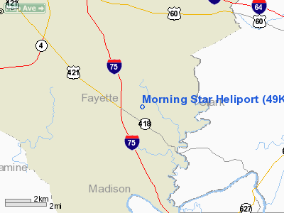
Morning Star Heliport
Address:
Fayette County, KY
Tel:
606-263-2407
Images
and information placed above are from
http://www.airport-data.com/airport/49KY/
We
thank them for the data!
|
General Info |
| Country |
United
States |
| State |
KENTUCKY
|
| FAA ID |
49KY
|
| Latitude |
37-57-49.282N |
|
Longitude |
084-22-12.762W |
|
Elevation |
916 feet
|
| Near
City |
LEXINGTON |
We don't guarantee the information is fresh and accurate. The data may
be wrong or outdated.
For more up-to-date information please refer to other sources.
|
|


