 |
|
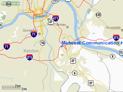
Midwest Communication Heliport |
|
Location &
QuickFacts
|
FAA
Information Effective: |
2008-09-25 |
|
Airport
Identifier: |
87KY |
|
Airport
Status: |
Operational |
|
Longitude/Latitude: |
084-27-49.7880W/39-02-44.2190N
-84.463830/39.045616 (Estimated) |
|
Elevation: |
850 ft / 259.08 m (Estimated) |
|
Land: |
30 acres |
|
From
nearest city: |
1 nautical miles W of Highland Heights, KY |
|
Location: |
Campbell County, KY |
|
Magnetic Variation: |
03W (1985) |
Owner & Manager
|
Ownership: |
Privately owned |
|
Owner: |
Midwest Communication |
|
Address: |
Four Tesseneer Drive
Highland Heights, KY 41076 |
|
Phone number: |
513-871-3261 |
|
Manager: |
Thomas Bland |
|
Address: |
455 Wilmer Ave
Cincinnati, OH 45226 |
|
Phone number: |
513-871-3261 |
Airport
Operations and Facilities
|
Airport
Use: |
Private |
|
Segmented Circle: |
No |
|
Control
Tower: |
No |
|
Sectional chart: |
Cincinnati |
|
Region: |
ASO - Southern |
|
Boundary
ARTCC: |
ZID - Indianapolis |
|
Tie-in
FSS: |
LOU - Louisville |
|
FSS Toll
Free: |
1-800-WX-BRIEF |
|
Runway Information
Helipad H1
|
Dimension: |
23 x 23 ft / 7.0 x 7.0 m |
|
Surface: |
CONC, |
|
|
Runway H1
|
Runway
|
|
Traffic
Pattern: |
Left |
Left |
|
Radio Navigation Aids
|
ID |
Type |
Name |
Ch |
Freq |
Var |
Dist |
|
LUK |
NDB |
Cincinnati |
|
335.00 |
04W |
8.9 nm |
|
PWF |
NDB |
Sportys |
|
245.00 |
04W |
11.7 nm |
|
MDE |
NDB |
Madeira |
|
379.00 |
04W |
11.8 nm |
|
ISZ |
NDB |
Cincinnati-blue Ash |
|
388.00 |
04W |
12.7 nm |
|
UR |
NDB |
Burln |
|
321.00 |
04W |
14.4 nm |
|
HAO |
NDB |
Hamilton |
|
260.00 |
04W |
20.3 nm |
|
HKF |
NDB |
Hook Field |
|
239.00 |
04W |
27.2 nm |
|
OXD |
NDB |
Oxford |
|
282.00 |
04W |
31.4 nm |
|
HW |
NDB |
Cubla |
|
299.00 |
04W |
33.1 nm |
|
HLB |
NDB |
Batesville |
|
254.00 |
02W |
41.3 nm |
|
IL |
NDB |
Airbo |
|
407.00 |
04W |
43.2 nm |
|
AMT |
NDB |
West Union |
|
359.00 |
04W |
43.6 nm |
|
HOC |
NDB |
Hillsboro |
|
278.00 |
05W |
43.8 nm |
|
XEN |
NDB |
Xenia |
|
395.00 |
03W |
47.3 nm |
|
XW |
NDB |
Flmng |
|
400.00 |
05W |
47.6 nm |
|
IMS |
NDB |
Madison |
|
404.00 |
03W |
49.7 nm |
|
FLM |
VOR/DME |
Falmouth |
117X |
117.00 |
04W |
24.9 nm |
|
MXQ |
VOR/DME |
Midwest |
076X |
112.90 |
04W |
38.5 nm |
|
CVG |
VORTAC |
Cincinnati |
120X |
117.30 |
04W |
11.3 nm |
|
RID |
VORTAC |
Richmond |
043X |
110.60 |
03W |
46.1 nm |
|
LUK |
VOT |
Cincinnati Muni/lunken |
|
108.40 |
|
5.2 nm |
Remarks
-
PRVDD ALL OPNS
CONDUCTED IN VFR WX; LNDG AREA LIMITED TO PRIVATE USE; ALL APCH/DEP OPNS
CONDUCTED IN AN AREA 150-190 DEGREES AND FM 300-030 DEGREES; TKOF/LNDG AREA IS
MKD.
Midwest Communication Heliport
Address:
Campbell County, KY
Tel:
513-871-3261
Images
and information placed above are from
http://www.airport-data.com/airport/87KY/
We
thank them for the data!
|
General Info |
| Country |
United
States |
| State |
KENTUCKY
|
| FAA ID |
87KY
|
| Latitude |
39-02-44.219N |
|
Longitude |
084-27-49.788W |
|
Elevation |
850 feet
|
| Near
City |
HIGHLAND
HEIGHTS |
We don't guarantee the information is fresh and accurate. The data may
be wrong or outdated.
For more up-to-date information please refer to other sources.
|
|


