 |
|
| McCreary County Airport |
| IATA: none – ICAO: none – FAA LID: 18I |
| Summary |
| Airport type |
Public |
| Operator |
McCreary County |
| Location |
Pine Knot, Kentucky |
| Elevation AMSL |
1,370 ft / 417.6 m |
| Coordinates |
36°41′45″N 84°23′30″W / 36.69583°N 84.39167°W / 36.69583; -84.39167Coordinates: 36°41′45″N 84°23′30″W / 36.69583°N 84.39167°W / 36.69583; -84.39167 |
| Runways |
| Direction |
Length |
Surface |
| ft |
m |
| 4/22 |
3,000 |
914 |
Asphalt |
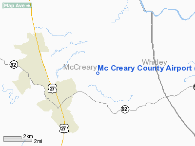
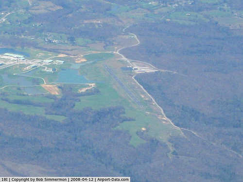
McCreary County Airport (FAA LID: 18I) is a public airport located three miles (4.8 km) northeast of the central business district (CBD) of Pine Knot, in McCreary County, Kentucky, USA. It is a very small, publicly owned public-use general aviation airport. The airport lies adjacent to United States Penitentiary, McCreary and has one unattended hangar containing several ultralight aircraft. Its elevation is 1370 MSL and it has one well-maintained asphalt runway, 4/22.
In 2003, Senator Jim Bunning announced that federal funding was being extended to McCreary County Airport. Plans are in development to extend the runway and build additional hangar space.
The above content comes from Wikipedia and is published under free licenses – click here to read more.
|
 |
(Click on the photo to enlarge) |
|
Location &
QuickFacts
|
FAA
Information Effective: |
2008-09-25 |
|
Airport
Identifier: |
18I |
|
Airport
Status: |
Operational |
|
Longitude/Latitude: |
084-23-29.2000W/36-41-43.2000N
-84.391444/36.695333 (Estimated) |
|
Elevation: |
1370 ft / 417.58 m (Surveyed) |
|
Land: |
165 acres |
|
From
nearest city: |
3 nautical miles NE of Pine Knot, KY |
|
Location: |
Mc Creary County, KY |
|
Magnetic Variation: |
03W (1985) |
Owner & Manager
|
Ownership: |
Publicly owned |
|
Owner: |
Mc Creary County |
|
Address: |
County Courthouse
Whitley City, KY 42653 |
|
Manager: |
Mc Creary Co Airport Board |
|
Address: |
P O Box 547
Pine Knot, KY 42633 |
|
Phone number: |
606-354-3593 |
Airport Operations and Facilities
|
Airport
Use: |
Open to public |
|
Wind
indicator: |
Yes |
|
Segmented Circle: |
Yes |
|
Control
Tower: |
No |
|
Lighting
Schedule: |
DUSK-DAWN
ACTVT MIRL RY 04/22, REIL RYS 04 & 22 - CTAF. |
|
Beacon
Color: |
Clear-Green (lighted land airport) |
|
Landing
fee charge: |
No |
|
Sectional chart: |
Cincinnati |
|
Region: |
ASO - Southern |
|
Boundary
ARTCC: |
ZID - Indianapolis |
|
Tie-in
FSS: |
LOU - Louisville |
|
FSS on
Airport: |
No |
|
FSS Toll
Free: |
1-800-WX-BRIEF |
|
NOTAMs
Facility: |
LOU (NOTAM-d service avaliable) |
|
Federal Agreements: |
N |
Airport Communications
Airport Services
|
Fuel
available: |
100LL
24 HR CREDIT CARD SVC AVBL. |
|
Airframe
Repair: |
NONE |
|
Power
Plant Repair: |
NONE |
|
Bottled
Oxygen: |
NONE |
|
Bulk
Oxygen: |
NONE |
|
Runway Information
Runway 04/22
|
Dimension: |
3000 x 75 ft / 914.4 x 22.9 m |
|
Surface: |
ASPH, Good Condition |
|
Weight Limit: |
Single wheel: 8000 lbs. |
|
Edge Lights: |
Medium |
|
|
Runway 04
|
Runway 22
|
|
Longitude: |
084-23-39.8600W |
084-23-18.6400W |
|
Latitude: |
36-41-31.1100N |
36-41-55.3700N |
|
Traffic
Pattern: |
Left |
Left |
|
Markings: |
Basic, Good Condition |
Basic, Good Condition |
|
Runway End
Identifier: |
Yes |
Yes |
|
Obstruction: |
32 ft trees, 1050.0 ft from runway, 50 ft left of
centerline, 26:1 slope to clear
+15 FT TREES 150 FT FROM RY END 100 FT RIGHT. |
, 50:1 slope to clear |
|
Radio Navigation Aids
|
ID |
Type |
Name |
Ch |
Freq |
Var |
Dist |
|
BPO |
NDB |
Piney Grove |
|
403.00 |
05W |
10.2 nm |
|
CDX |
NDB |
Cumberland River |
|
388.00 |
05E |
22.8 nm |
|
JAU |
NDB |
Jacksboro |
|
204.00 |
03W |
24.2 nm |
|
EKQ |
NDB |
Elk Spring |
|
290.00 |
03W |
24.2 nm |
|
LOZ |
VORTAC |
London |
108X |
116.10 |
03W |
24.4 nm |
|
LVT |
VORTAC |
Livingston |
021X |
108.40 |
02W |
38.0 nm |
Remarks
Based Aircraft
|
Aircraft based
on field: |
2 |
|
Single Engine
Airplanes: |
2 |
Operational Statistics
Time Period: 2006-09-20 - 2007-09-19
|
Aircraft
Operations: |
25/Week |
|
Air Taxi: |
3.8% |
|
General
Aviation Local: |
38.5% |
|
General
Aviation Itinerant: |
53.8% |
|
Military: |
3.8% |
Mc Creary County Airport
Address:
Mc Creary County, KY
Tel:
606-354-3593
Images
and information placed above are from
http://www.airport-data.com/airport/18I/
We
thank them for the data!
|
General Info |
| Country |
United
States |
| State |
KENTUCKY
|
| FAA ID |
18I
|
| Latitude |
36-41-45.287N |
|
Longitude |
084-23-29.774W |
|
Elevation |
1370
feet |
| Near
City |
PINE
KNOT |
We don't guarantee the information is fresh and accurate. The data may
be wrong or outdated.
For more up-to-date information please refer to other sources.
|
|


