 |
|
Madisonville Municipal Airport |
| Madisonville Municipal Airport |
| IATA: none â ICAO: none â FAA LID: 2I0 |
| Summary |
| Airport type |
Public |
| Owner |
City of Madisonville |
| Serves |
Madisonville, Kentucky |
| Elevation AMSL |
439 ft / 134 m |
| Coordinates |
37°21â²21â³N 087°23â²54â³W / 37.35583°N 87.39833°W / 37.35583; -87.39833 |
| Runways |
| Direction |
Length |
Surface |
| ft |
m |
| 5/23 |
6,050 |
1,844 |
Asphalt |
| Statistics (2008) |
| Aircraft operations |
17,054 |
| Based aircraft |
17 |
| Source: Federal Aviation Administration |
This article is about the airport in Kentucky.For other similarly named airports, see Madisonville Municipal Airport.
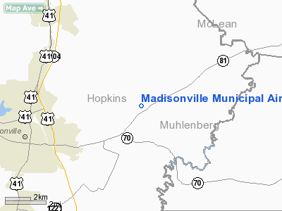
Madisonville Municipal Airport (FAA LID: 2I0) is a city-owned public-use airport located five nautical miles (9 km) northeast of the central business district of Madisonville, a city in Hopkins County, Kentucky, United States.
Facilities and aircraft
Madisonville Municipal Airport covers an area of 215 acres (87 ha) at an elevation of 439 feet (134 m) above mean sea level. It has one asphalt paved runway designated 5/23 which measures 6,050 by 100 feet (1,844 x 30 m).
For the 12-month period ending October 14, 2008, the airport had 17,054 aircraft operations, an average of 46 per day: 78% general aviation, 19% air taxi and 3% military. At that time there were 17 aircraft based at this airport: 88% single-engine, 6% multi-engine and 6% jet.
The above content comes from Wikipedia and is published under free licenses – click here to read more.
|
Location &
QuickFacts
|
FAA
Information Effective: |
2008-09-25 |
|
Airport
Identifier: |
2I0 |
|
Airport
Status: |
Operational |
|
Longitude/Latitude: |
087-23-58.7000W/37-21-18.1000N
-87.399639/37.355028 (Estimated) |
|
Elevation: |
439 ft / 133.81 m (Surveyed) |
|
Land: |
215 acres |
|
From
nearest city: |
5 nautical miles NE of Madisonville, KY |
|
Location: |
Hopkins County, KY |
|
Magnetic Variation: |
00E (1980) |
Owner & Manager
|
Ownership: |
Publicly owned |
|
Owner: |
City Of Madisonville |
|
Address: |
City Hall
Madisonville, KY 42431 |
|
Phone number: |
270-824-2110
MADISONVILLE MAYOR. |
|
Manager: |
Edward Goode |
|
Address: |
162 Airport Road
Madisonville, KY 42431 |
|
Phone number: |
270-821-3453 |
Airport
Operations and Facilities
|
Airport
Use: |
Open to public |
|
Wind
indicator: |
Yes |
|
Segmented Circle: |
Yes |
|
Control
Tower: |
No |
|
Lighting
Schedule: |
DUSK-DAWN
HIRL RY 05/23 PRESET LOW INTST; TO INCR INTST & ACTVT REIL RYS 05 & 23
- CTAF. |
|
Beacon
Color: |
Clear-Green (lighted land airport) |
|
Landing
fee charge: |
No |
|
Sectional chart: |
St Louis |
|
Region: |
ASO - Southern |
|
Boundary
ARTCC: |
ZID - Indianapolis |
|
Tie-in
FSS: |
LOU - Louisville |
|
FSS on
Airport: |
No |
|
FSS Toll
Free: |
1-800-WX-BRIEF |
|
NOTAMs
Facility: |
LOU (NOTAM-d service avaliable) |
|
Federal Agreements: |
NGY |
Airport Communications
|
CTAF: |
122.700 |
|
Unicom: |
122.700 |
Airport Services
|
Fuel
available: |
100 A |
|
Airframe
Repair: |
MAJOR |
|
Power
Plant Repair: |
MINOR |
|
Bottled
Oxygen: |
HIGH |
|
Bulk
Oxygen: |
HIGH |
|
Runway Information
Runway 05/23
|
Dimension: |
6050 x 100 ft / 1844.0 x 30.5 m |
|
Surface: |
ASPH, Good Condition |
|
Weight Limit: |
Single wheel: 75000 lbs.
Dual wheel: 130000 lbs. |
|
Edge Lights: |
High |
|
|
Runway 05
|
Runway 23
|
|
Longitude: |
087-24-22.9200W |
087-23-24.2800W |
|
Latitude: |
37-21-02.7300N |
37-21-39.9700N |
|
Elevation: |
439.00 ft |
418.00 ft |
|
Alignment: |
51 |
127 |
|
Traffic
Pattern: |
Left |
Left |
|
Markings: |
Non-precision instrument, Good Condition |
Non-precision instrument, Good Condition |
|
Crossing
Height: |
33.00 ft |
45.00 ft |
|
VASI: |
4-light PAPI on left side |
4-light PAPI on left side |
|
Visual
Glide Angle: |
3.00° |
3.00° |
|
Runway End
Identifier: |
Yes |
Yes |
|
Obstruction: |
98 ft pole, 910.0 ft from runway, 590 ft left of
centerline, 17:1 slope to clear |
|
|
Radio Navigation Aids
|
ID |
Type |
Name |
Ch |
Freq |
Var |
Dist |
|
GMH |
NDB |
Muhlenberg |
|
362.00 |
01E |
13.8 nm |
|
TWT |
NDB |
Tradewater |
|
276.00 |
00E |
27.0 nm |
|
HIX |
NDB |
Honey Grove |
|
356.00 |
01W |
28.7 nm |
|
GVA |
NDB |
Geneva |
|
224.00 |
01W |
32.2 nm |
|
FK |
NDB |
Airbe |
|
273.00 |
01W |
37.2 nm |
|
PDW |
NDB |
Evansville |
|
284.00 |
00E |
41.7 nm |
|
HXW |
TACAN |
Screaming Eagle |
096X |
|
01W |
41.1 nm |
|
OWB |
VOR/DME |
Owensboro |
023X |
108.60 |
01E |
25.9 nm |
|
CKV |
VOR/DME |
Clarksville |
043X |
110.60 |
01W |
44.1 nm |
|
CCT |
VORTAC |
Central City |
035X |
109.80 |
01W |
6.7 nm |
|
PXV |
VORTAC |
Pocket City |
080X |
113.30 |
03E |
38.5 nm |
Based Aircraft
|
Aircraft based
on field: |
12 |
|
Single Engine
Airplanes: |
9 |
|
Multi Engine
Airplanes: |
2 |
|
Jet Engine
Airplanes: |
1 |
Operational Statistics
Time Period: 2005-03-01 - 2006-02-28
|
Aircraft
Operations: |
47/Day |
|
Air Taxi: |
18.8% |
|
General
Aviation Local: |
23.1% |
|
General
Aviation Itinerant: |
55.4% |
|
Military: |
2.8% |
Madisonville Municipal Airport
Address:
Hopkins County, KY
Tel:
270-824-2110, 270-821-3453
Images
and information placed above are from
http://www.airport-data.com/airport/2I0/
We
thank them for the data!
|
General Info |
| Country |
United
States |
| State |
KENTUCKY
|
| FAA ID |
2I0
|
| Latitude |
37-21-18.100N |
|
Longitude |
087-23-58.700W |
|
Elevation |
439 feet
|
| Near
City |
MADISONVILLE |
We don't guarantee the information is fresh and accurate. The data may
be wrong or outdated.
For more up-to-date information please refer to other sources.
|
|


