 |
|
|
|
|
|
|
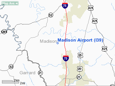
Location &
QuickFacts
|
FAA
Information Effective: |
2008-09-25 |
|
Airport
Identifier: |
I39 |
|
Airport
Status: |
Operational |
|
Longitude/Latitude: |
084-19-56.4140W/37-37-51.0510N
-84.332337/37.630848 (Estimated) |
|
Elevation: |
1002 ft / 305.41 m (Surveyed) |
|
Land: |
197 acres |
|
From
nearest city: |
8 nautical miles SW of Richmond, KY |
|
Location: |
Madison County, KY |
|
Magnetic Variation: |
01W (1980) |
Owner & Manager
|
Ownership: |
Publicly owned |
|
Owner: |
Madison Airport Board Inc |
|
Address: |
Po Box 1110
Berea, KY 40403 |
|
Phone
number: |
859-986-8418 |
|
Manager: |
Nathan T. Hoskins
AIRPORT BOARD CHAIRMAN: CLIFFORD KERBY. |
|
Address: |
124 Madison Airport Rd.
Richmond, KY 40475 |
|
Phone number: |
859-986-3913 |
Airport Operations and Facilities
|
Airport
Use: |
Open to public |
|
Wind
indicator: |
Yes |
|
Segmented Circle: |
Yes |
|
Control
Tower: |
No |
|
Lighting
Schedule: |
DUSK-DAWN
ACTVT MIRL, PAPI, REIL RY 18/36 - CTAF. |
|
Beacon
Color: |
Clear-Green (lighted land airport) |
|
Landing
fee charge: |
No |
|
Sectional chart: |
Cincinnati |
|
Region: |
ASO - Southern |
|
Boundary
ARTCC: |
ZID - Indianapolis |
|
Tie-in
FSS: |
LOU - Louisville |
|
FSS on
Airport: |
No |
|
FSS Toll
Free: |
1-800-WX-BRIEF |
|
NOTAMs
Facility: |
LOU (NOTAM-d service avaliable) |
|
Federal Agreements: |
NGY |
Airport Communications
|
CTAF: |
122.800 |
|
Unicom: |
122.800 |
Airport Services
|
Fuel
available: |
100LLA |
|
Airframe
Repair: |
MAJOR |
|
Power
Plant Repair: |
MAJOR |
|
Bottled
Oxygen: |
NONE |
|
Bulk
Oxygen: |
NONE |
|
Runway Information
Runway 18/36
|
Dimension: |
4500 x 100 ft / 1371.6 x 30.5 m |
|
Surface: |
ASPH, Good Condition |
|
Weight Limit: |
Single wheel: 12500 lbs. |
|
Edge Lights: |
Medium |
|
|
Runway 18
|
Runway 36
|
|
Longitude: |
084-19-59.1066W |
084-19-53.8764W |
|
Latitude: |
37-38-13.2057N |
37-37-28.9074N |
|
Elevation: |
967.00 ft |
1002.00 ft |
|
Alignment: |
127 |
127 |
|
Traffic
Pattern: |
Left |
Left |
|
Markings: |
Non-precision instrument, Good Condition |
Non-precision instrument, Good Condition |
|
Crossing
Height: |
22.00 ft |
24.00 ft |
|
Displaced
threshold: |
90.00 ft |
0.00 ft |
|
VASI: |
4-light PAPI on left side |
4-light PAPI on left side |
|
Visual
Glide Angle: |
3.00° |
3.00° |
|
Runway End
Identifier: |
Yes |
Yes |
|
Obstruction: |
12 ft trees, 260.0 ft from runway, 180 ft right of
centerline, 5:1 slope to clear
APCH RATIO 29:1 TO DSPLCD THLD. |
15 ft trees, 500.0 ft from runway, 20:1 slope to clear |
|
Radio Navigation Aids
|
ID |
Type |
Name |
Ch |
Freq |
Var |
Dist |
|
XYC |
NDB |
Seco |
|
393.00 |
03W |
16.3 nm |
|
DVK |
NDB |
Goodall |
|
311.00 |
03W |
20.8 nm |
|
LE |
NDB |
Blayd |
|
242.00 |
04W |
26.5 nm |
|
IOB |
NDB |
Mount Sterling |
|
210.00 |
04W |
30.7 nm |
|
CDX |
NDB |
Cumberland River |
|
388.00 |
05E |
41.6 nm |
|
FEU |
NDB |
Arnold |
|
521.00 |
03W |
42.0 nm |
|
IKY |
NDB |
Springfield |
|
429.00 |
03W |
43.0 nm |
|
TYC |
NDB |
Taylor County |
|
272.00 |
02W |
45.6 nm |
|
FFT |
VOR |
Frankfort |
|
109.40 |
03W |
43.0 nm |
|
HYK |
VORTAC |
Lexington |
073X |
112.60 |
00E |
21.2 nm |
|
LOZ |
VORTAC |
London |
108X |
116.10 |
03W |
37.5 nm |
Remarks
-
OPERATOR: ALGAN
LAKE - PHONE 859-986-3913 OR 3128.
-
OPERATIONS ARE
CONDUCTED WEST OF RY CNTRLN & RY CNTRLN EXTNDD.
Based Aircraft
|
Aircraft based
on field: |
23 |
|
Single Engine
Airplanes: |
22 |
|
Helicopters: |
1 |
Operational Statistics
Time Period: 2005-05-06 - 2006-05-05
|
Aircraft
Operations: |
295/Week |
|
Air Taxi: |
9.2% |
|
General
Aviation Local: |
44.4% |
|
General
Aviation Itinerant: |
43.8% |
|
Military: |
2.6% |
Madison Airport
Address:
Madison County, KY
Tel:
859-986-8418,
859-986-3913
Images
and information placed above are from
http://www.airport-data.com/airport/I39/
We
thank them for the data!
|
|


