 |
|
|
Location &
QuickFacts
|
FAA
Information Effective: |
2008-09-25 |
|
Airport
Identifier: |
20KY |
|
Airport
Status: |
Operational |
|
Longitude/Latitude: |
084-40-16.0000W/38-49-01.0000N
-84.671111/38.816944 (Estimated) |
|
Elevation: |
880 ft / 268.22 m (Estimated) |
|
Land: |
0 acres |
|
From
nearest city: |
1 nautical miles SW of Verona, KY |
|
Location: |
Boone County, KY |
|
Magnetic Variation: |
() |
Owner & Manager
|
Ownership: |
Privately owned |
|
Owner: |
Gordon Palmer |
|
Address: |
923 Riva Ridge
Union, KY 41091 |
|
Phone number: |
859-393-2595 |
|
Manager: |
Greg S. Palmer |
|
Address: |
2479 Peppermill Court
Verona, KY 41092-9235 |
|
Phone number: |
859-393-2595 |
Airport
Operations and Facilities
|
Airport
Use: |
Private |
|
Control
Tower: |
No |
|
Sectional chart: |
Cincinnati |
|
Region: |
ASO - Southern |
|
Boundary
ARTCC: |
ZID - Indianapolis |
|
Tie-in
FSS: |
LOU - Louisville |
|
FSS Toll
Free: |
1-800-WX-BRIEF |
|
Runway Information
Runway 05/23
|
Dimension: |
1800 x 100 ft / 548.6 x 30.5 m |
|
Surface: |
TURF, |
|
|
Runway 05
|
Runway 23
|
|
Traffic
Pattern: |
Left |
Left |
|
Radio Navigation Aids
|
ID |
Type |
Name |
Ch |
Freq |
Var |
Dist |
|
UR |
NDB |
Burln |
|
321.00 |
04W |
14.6 nm |
|
LUK |
NDB |
Cincinnati |
|
335.00 |
04W |
25.7 nm |
|
PWF |
NDB |
Sportys |
|
245.00 |
04W |
26.4 nm |
|
MDE |
NDB |
Madeira |
|
379.00 |
04W |
28.5 nm |
|
ISZ |
NDB |
Cincinnati-blue Ash |
|
388.00 |
04W |
29.1 nm |
|
HAO |
NDB |
Hamilton |
|
260.00 |
04W |
33.7 nm |
|
FEU |
NDB |
Arnold |
|
521.00 |
03W |
36.9 nm |
|
IMS |
NDB |
Madison |
|
404.00 |
03W |
37.1 nm |
|
OXD |
NDB |
Oxford |
|
282.00 |
04W |
41.8 nm |
|
HLB |
NDB |
Batesville |
|
254.00 |
02W |
42.1 nm |
|
HKF |
NDB |
Hook Field |
|
239.00 |
04W |
42.3 nm |
|
OVO |
NDB |
North Vernon |
|
374.00 |
02W |
45.7 nm |
|
HW |
NDB |
Cubla |
|
299.00 |
04W |
49.2 nm |
|
LE |
NDB |
Blayd |
|
242.00 |
04W |
49.9 nm |
|
FFT |
VOR |
Frankfort |
|
109.40 |
03W |
39.7 nm |
|
FLM |
VOR/DME |
Falmouth |
117X |
117.00 |
04W |
19.7 nm |
|
CVG |
VORTAC |
Cincinnati |
120X |
117.30 |
04W |
12.1 nm |
|
ABB |
VORTAC |
Nabb |
071X |
112.40 |
01E |
47.3 nm |
|
LUK |
VOT |
Cincinnati Muni/lunken |
|
108.40 |
|
22.0 nm |
Remarks
-
OWNER DESIRES
ARPT NOT BE CHARTED.
-
130 FT WATER TWR
1400 FT NORTH, AND 300 FT CELL TWR 1.5 NM NW OF ARPT.
-
PRVDD VFR OPNS,
PVT USE, AND LOA WITH MUELLER FARM ARPT AND FARM ARPT.
Based Aircraft
|
Aircraft based
on field: |
1 |
|
Single Engine
Airplanes: |
1 |
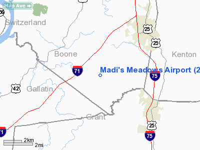
Madi's Meadows Airport
Address:
Boone County, KY
Tel:
859-393-2595
Images
and information placed above are from
http://www.airport-data.com/airport/20KY/
We
thank them for the data!
|
General Info |
| Country |
United
States |
| State |
KENTUCKY
|
| FAA ID |
20KY
|
| Latitude |
36-51-45.176N |
|
Longitude |
087-47-25.055W |
|
Elevation |
498 feet
|
| Near
City |
CADIZ
|
We don't guarantee the information is fresh and accurate. The data may
be wrong or outdated.
For more up-to-date information please refer to other sources.
|
|


