|
|
|
 |
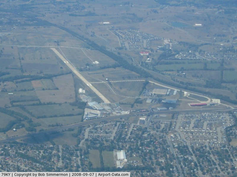
(Click on the photo to enlarge) |
|
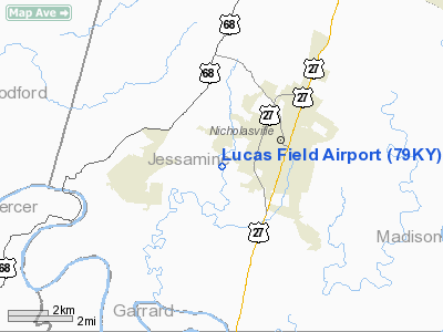
Location &
QuickFacts
|
FAA
Information Effective: |
2008-09-25 |
|
Airport
Identifier: |
79KY |
|
Airport
Status: |
Operational |
|
Longitude/Latitude: |
084-36-37.9000W/37-52-16.6000N
-84.610528/37.871278 (Estimated) |
|
Elevation: |
906 ft / 276.15 m (Surveyed) |
|
Land: |
257 acres |
|
From
nearest city: |
1 nautical miles W of Nicholasville, KY |
|
Location: |
Jessamine County, KY |
|
Magnetic Variation: |
() |
Owner & Manager
|
Ownership: |
Privately owned |
|
Owner: |
R. J. Corman |
|
Address: |
One Jay Station, P.o. Box 788
Nicholasville, KY 40356 |
|
Phone
number: |
859-885-4795 |
|
Manager: |
Troy Montgomery |
|
Address: |
One Jay Station, P.o. Box 788
Nicholasville, KY 40356 |
|
Phone number: |
859-885-4795 |
Airport Operations and Facilities
|
Airport
Use: |
Private |
|
Wind
indicator: |
Yes |
|
Control
Tower: |
No |
|
Lighting
Schedule: |
PHONE REQ |
|
Sectional chart: |
Cincinnati |
|
Region: |
ASO - Southern |
|
Boundary
ARTCC: |
ZID - Indianapolis |
|
Tie-in
FSS: |
LOU - Louisville |
|
FSS Toll
Free: |
1-800-WX-BRIEF |
|
Runway Information
Runway 09/27
|
Dimension: |
5488 x 100 ft / 1672.7 x 30.5 m |
|
Surface: |
CONC, |
|
Edge Lights: |
High
FOR HIRL RY 09/27 CALL 859-885-4795. |
|
|
Runway 09
|
Runway 27
|
|
Longitude: |
084-37-12.0962W |
084-36-03.7880W |
|
Latitude: |
37-52-18.2958N |
37-52-14.9325N |
|
Elevation: |
905.00 ft |
898.00 ft |
|
Traffic
Pattern: |
Left |
Left |
|
Displaced
threshold: |
526.00 ft |
508.00 ft |
|
Obstruction: |
133 ft pline, 2150.0 ft from runway |
60 ft pline, 665.0 ft from runway |
|
Radio Navigation Aids
|
ID |
Type |
Name |
Ch |
Freq |
Var |
Dist |
|
LE |
NDB |
Blayd |
|
242.00 |
04W |
7.4 nm |
|
DVK |
NDB |
Goodall |
|
311.00 |
03W |
19.2 nm |
|
FEU |
NDB |
Arnold |
|
521.00 |
03W |
22.9 nm |
|
XYC |
NDB |
Seco |
|
393.00 |
03W |
28.4 nm |
|
IOB |
NDB |
Mount Sterling |
|
210.00 |
04W |
31.9 nm |
|
IKY |
NDB |
Springfield |
|
429.00 |
03W |
33.0 nm |
|
TYC |
NDB |
Taylor County |
|
272.00 |
02W |
41.3 nm |
|
BRY |
NDB |
Bardstown/dcmsnd |
|
248.00 |
02W |
41.4 nm |
|
FFT |
VOR |
Frankfort |
|
109.40 |
03W |
23.4 nm |
|
FLM |
VOR/DME |
Falmouth |
117X |
117.00 |
04W |
48.9 nm |
|
HYK |
VORTAC |
Lexington |
073X |
112.60 |
00E |
8.7 nm |
|
IIU |
VORTAC |
Louisville |
095X |
114.80 |
01E |
47.9 nm |
Based Aircraft
|
Aircraft based
on field: |
4 |
|
Jet Engine
Airplanes: |
2 |
|
Helicopters: |
2 |
Lucas Field Airport
Address:
Jessamine County, KY
Tel:
859-885-4795
Images
and information placed above are from
http://www.airport-data.com/airport/79KY/
We
thank them for the data!
|
General Info |
| Country |
United
States |
| State |
KENTUCKY
|
| FAA ID |
79KY
|
| Latitude |
37.871278
37° 52' 16.60" N |
|
Longitude |
-84.610528
084° 36' 37.90" W |
|
Elevation |
906 feet
276 meters |
| Magnetic
Variation |
004° W
(01/06) |
| Beacon |
Yes
|
|
Operating Agency |
PRIVATE
|
We don't guarantee the information is fresh and accurate. The data may
be wrong or outdated.
For more up-to-date information please refer to other sources.
|
|