 |
|
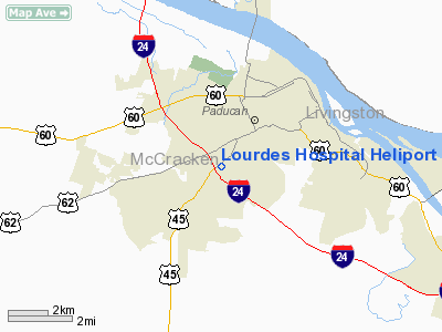
Lourdes Hospital Heliport |
|
Location &
QuickFacts
|
FAA
Information Effective: |
2008-09-25 |
|
Airport
Identifier: |
01KY |
|
Airport
Status: |
Operational |
|
Longitude/Latitude: |
088-38-49.0000W/37-03-06.0000N
-88.646944/37.051667 (Estimated) |
|
Elevation: |
419 ft / 127.71 m (Estimated) |
|
Land: |
0 acres |
|
From
nearest city: |
0 nautical miles N of Paducah, KY |
|
Location: |
Mc Cracken County, KY |
|
Magnetic Variation: |
00E (1990) |
Owner & Manager
|
Ownership: |
Privately owned |
|
Owner: |
Cath Hlthcare Partners Lourdes Hosp |
|
Address: |
1530 Lone Oak Road
Paducah, KY 42003 |
|
Phone
number: |
270-444-2119 |
|
Manager: |
Dale Mapes |
|
Address: |
1530 Lone Oak Road
Paducah, KY 42003 |
|
Phone number: |
270-444-2119 |
Airport Operations and Facilities
|
Airport
Use: |
Private
MEDICAL USE. |
|
Wind
indicator: |
Yes |
|
Segmented Circle: |
No |
|
Control
Tower: |
No |
|
Lighting
Schedule: |
PHONE REQ
FOR PERIMETER LGTS CALL 270-444-2444. |
|
Sectional chart: |
St Louis |
|
Region: |
ASO - Southern |
|
Boundary
ARTCC: |
ZME - Memphis |
|
Tie-in
FSS: |
LOU - Louisville |
|
FSS on
Airport: |
No |
|
FSS Toll
Free: |
1-800-WX-BRIEF |
|
Runway Information
Helipad H1
|
Dimension: |
40 x 40 ft / 12.2 x 12.2 m |
|
Surface: |
CONC, |
|
|
Runway H1
|
Runway
|
|
Traffic
Pattern: |
Left |
Left |
|
Radio Navigation Aids
|
ID |
Type |
Name |
Ch |
Freq |
Var |
Dist |
|
BDD |
NDB |
Bellgrade |
|
254.00 |
00E |
5.8 nm |
|
GGK |
NDB |
Mayfield |
|
401.00 |
00E |
21.8 nm |
|
CIR |
NDB |
Cairo |
|
397.00 |
00E |
27.7 nm |
|
CHQ |
NDB |
Charleston |
|
208.00 |
01E |
36.3 nm |
|
TWT |
NDB |
Tradewater |
|
276.00 |
00E |
41.8 nm |
|
HSB |
NDB |
Harrisburg-raleigh |
|
230.00 |
00E |
45.9 nm |
|
UC |
NDB |
Obion |
|
212.00 |
00E |
48.3 nm |
|
TIQ |
NDB |
Trainer |
|
410.00 |
00E |
49.5 nm |
|
CGI |
VOR/DME |
Cape Girardeau |
076X |
112.90 |
01E |
45.6 nm |
|
MWA |
VOR/DME |
Marion |
041X |
110.40 |
04E |
45.7 nm |
|
CNG |
VORTAC |
Cunningham |
078X |
113.10 |
03E |
9.5 nm |
Remarks
-
PRVDD ALL APCH/DEP
ROUTES ALIGNED ON 300 & 120 DEGS, AREA IS MKD, WIND INDICATOR MAINTAINED.
Lourdes Hospital Heliport
Address:
Mc Cracken County, KY
Tel:
270-444-2119
Images
and information placed above are from
http://www.airport-data.com/airport/01KY/
We
thank them for the data!
|
General Info |
| Country |
United
States |
| State |
KENTUCKY
|
| FAA ID |
01KY
|
| Latitude |
37-03-06.000N |
|
Longitude |
088-38-49.000W |
|
Elevation |
419 feet
|
| Near
City |
PADUCAH
|
We don't guarantee the information is fresh and accurate. The data may
be wrong or outdated.
For more up-to-date information please refer to other sources.
|
|


