|
 |
|
||||
|
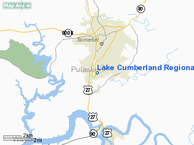
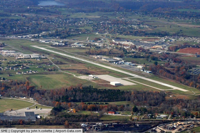
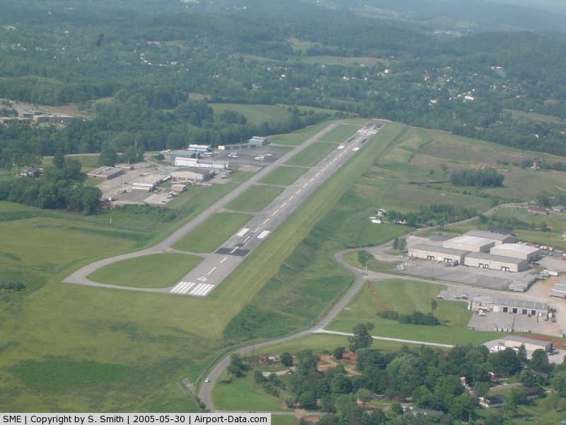
Lake Cumberland Regional Airport (IATA: SME, ICAO: KSME, FAA LID: SME) is a public use airport located three nautical miles (6 km) south of the central business district of Somerset, a city in Pulaski County, Kentucky, United States. The airport is owned by the city of Somerset and Pulaski County. It also serves the area around Lake Cumberland. It is mostly used for general aviation, and from late 2008 until February 2010, was served by one commercial airline, Locair. Currently, the $3 million federally-funded passenger terminal is not in use. The airport was renamed in 2008; it was formerly known as Somerset-Pulaski County Airport or J.T. Wilson Field. Facilities and aircraftLake Cumberland Regional Airport covers an area of 288 acres (117 ha) at an elevation of 927 feet (283 m) above mean sea level. It has one asphalt paved runway designated 5/23 which measures 5,800 by 100 feet (1,768 x 30 m). For the 12-month period ending August 31, 2008, the airport had 27,605 aircraft operations, an average of 75 per day: 99% general aviation and 1% military. At that time there were 28 aircraft based at this airport: 71% single-engine, 14% multi-engine, 4% jet and 11% helicopter. Airlines and destinationsLake Cumberland Regional Airport currently does not have commercial service. The above content comes from Wikipedia and is published under free licenses – click here to read more.
Location &
QuickFacts
FAA
Information Effective:
2008-09-25
Airport
Identifier:
SME
Airport
Status:
Operational
Longitude/Latitude:
084-36-56.3000W/37-03-12.9000N
Elevation:
927 ft / 282.55 m (Surveyed)
Land:
288 acres
From
nearest city:
3 nautical miles S of Somerset, KY
Location:
Pulaski County, KY
Magnetic Variation:
05W (2005)
Owner & Manager
Ownership:
Publicly owned
Owner:
Somerset-pulaski County
Address:
222 Airport Rd.
Phone number:
606-678-4554
Manager:
Ron Swartz
Address:
222 Airport Rd
Phone number:
606-678-4554 Airport
Operations and Facilities
Airport
Use:
Open to public
Wind
indicator:
Yes
Segmented Circle:
Yes
Control
Tower:
No
Lighting
Schedule:
DUSK-DAWN
Beacon
Color:
Clear-Green (lighted land airport)
Landing
fee charge:
No
Sectional chart:
Cincinnati
Region:
ASO - Southern
Boundary
ARTCC:
ZID - Indianapolis
Tie-in
FSS:
LOU - Louisville
FSS on
Airport:
No
FSS Toll
Free:
1-800-WX-BRIEF
NOTAMs
Facility:
SME (NOTAM-d service avaliable)
Certification type/date:
II A S 06/200
Federal Agreements:
NGY
Airport Communications
CTAF:
122.800
Unicom:
122.800
Airport Services
Fuel
available:
100LLA
Airframe
Repair:
NONE
Power
Plant Repair:
NONE
Bottled
Oxygen:
NONE
Bulk
Oxygen:
NONE Runway Information
Dimension:
5800 x 100 ft / 1767.8 x 30.5 m
Surface:
ASPH, Fair Condition
Weight Limit:
Single wheel: 30000 lbs.
Edge Lights:
Medium
Longitude:
084-37-20.6555W
084-36-31.9662W
Latitude:
37-02-51.9447N
37-03-33.9394N
Elevation:
911.00 ft
921.00 ft
Alignment:
43
127
ILS Type:
ILS/DME
Traffic
Pattern:
Left
Left
Markings:
Precision instrument, Good Condition
Non-precision instrument, Good Condition
Crossing
Height:
44.00 ft
41.00 ft
Displaced
threshold:
513.00 ft
300.00 ft
VASI:
4-light PAPI on left side
4-light PAPI on left side
Visual
Glide Angle:
3.00°
4.00°
Runway End
Identifier:
Yes
Yes
Obstruction:
23 ft gnd, 650.0 ft from runway, 300 ft left of
centerline, 19:1 slope to clear
305 ft trees, 5900.0 ft from runway, 700 ft left of
centerline, 18:1 slope to clear
Decleard
distances:
Take off run available 5800.00 ft
Take off run available 5800.00 ft Radio Navigation Aids
ID
Type
Name
Ch
Freq
Var
Dist
CDX
NDB
Cumberland River
388.00
05E
4.7 nm
EKQ
NDB
Elk Spring
290.00
03W
16.5 nm
BPO
NDB
Piney Grove
403.00
05W
31.6 nm
DVK
NDB
Goodall
311.00
03W
32.2 nm
TYC
NDB
Taylor County
272.00
02W
36.6 nm
IKY
NDB
Springfield
429.00
03W
45.8 nm
JAU
NDB
Jacksboro
204.00
03W
48.3 nm
LOZ
VORTAC
London
108X
116.10
03W
24.3 nm
LVT
VORTAC
Livingston
021X
108.40
02W
38.7 nm Based Aircraft
Aircraft based
on field:
28
Single Engine
Airplanes:
20
Multi Engine
Airplanes:
4
Jet Engine
Airplanes:
1
Helicopters:
3 Operational Statistics
Time Period: 2005-09-23 - 2006-09-22
Aircraft
Operations:
81/Day
Air Taxi:
5.8%
General
Aviation Local:
31.5%
General
Aviation Itinerant:
62.0%
Military:
0.7%
Lake Cumberland Regional Airport Address:
Pulaski County, KY Tel:606-678-4554 Images
and information placed above are from We
thank them for the data!
|
||||||||||||||||||||||||||||||||||||||||||||||||||||||||||||||||||||||||||||||||||||||||||||||||||||||||||||||||||||||||||||||||||||||||||||||||||||||||||||||||||||||||||||||||||||||||||||||||||||||||||||||||||||||||||||||||||||||||||||||||||||||||||||||||||||||||||||||||||||||||||||||||||||||||||||||||||||||||||||||||||||

 |
|
Copyright 2004-2026 © by Airports-Worldwide.com, Vyshenskoho st. 36, Lviv 79010, Ukraine Legal Disclaimer |