 |
|
Kyle-Oakley Field Airport |
Murray-Calloway County Airport
Kyle-Oakley Field |
 |
| IATA: CEY â ICAO: KCEY â FAA LID: CEY |
| Summary |
| Airport type |
Public |
| Owner |
Murray City-Calloway County Board |
| Serves |
Murray, Kentucky |
| Elevation AMSL |
577 ft / 176 m |
| Coordinates |
36°39â²52â³N 088°22â²22â³W / 36.66444°N 88.37278°W / 36.66444; -88.37278 |
| Website |
MurrayKyleOakley.com |
| Runways |
| Direction |
Length |
Surface |
| ft |
m |
| 5/23 |
6,203 |
1,891 |
Asphalt |
| Statistics (2009) |
| Aircraft operations |
13,171 |
| Based aircraft |
33 |
| Source: Federal Aviation Administration, Airport website |
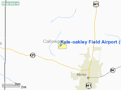
Murray-Calloway County Airport (IATA: CEY, ICAO: KCEY, FAA LID: CEY), also known as Kyle-Oakley Field, is a public use airport located four nautical miles (7 km) northwest of the central business district of Murray, in Calloway County, Kentucky, United States. The airport opened in 1961. It is owned by the Murray City-Calloway County Board. History
The need for an airport for Murray and Calloway County was apparent to further the growth and progress of the community. The Murray Chamber of Commerce knew of the interest which the Murray Jaycees had in working to obtain an airport. In the spring of 1957 the Murray Chamber of Commerce approached the Jaycees to offer their assistance and cooperation if the Jaycees would undertake the airport project. The Jaycees endorsed the project and a committee was appointed after approval by the board of directors. A campaign was established to obtain approval from the State Department of Aeronautics, with local residents, businesses and interested parties writing letters and making phone calls. The result was an approval to continue with the project. The Jaycees held a radio auction for the purpose of raising funds for the airport project. With the success of the auction it was evident that there would be an airport for Murray and Calloway County. On Saturday, October 28, 1961, Kentucky Governor Bert T. Combs dedicated the airport in a ceremony attended by state and local officials as well as many local citizens.
In the mid 1980s, a commuter type service called Sunbird Airlines had scheduled flights to Nashville using single engine Piper PA-32 aircraft. They lasted about four years.
Facilities and aircraft
The airport covers an area of 300 acres (121 ha) at an elevation of 577 feet (176 m) above mean sea level. It has one runway designated 5/23 with an asphalt surface measuring 6,203 by 100 feet (1,891 x 30 m).
For the 12-month period ending September 30, 2009, the airport had 13,171 aircraft operations, an average of 36 per day: 93% general aviation, 6% air taxi, and 1% military. At that time there were 33 aircraft based at this airport: 88% single-engine, 6% multi-engine, 3% helicopter and 3% ultralight.
The above content comes from Wikipedia and is published under free licenses – click here to read more.
|
Location &
QuickFacts
|
FAA
Information Effective: |
2008-09-25 |
|
Airport
Identifier: |
CEY |
|
Airport
Status: |
Operational |
|
Longitude/Latitude: |
088-22-21.9980W/36-39-52.5000N
-88.372777/36.664583 (Estimated) |
|
Elevation: |
576 ft / 175.56 m (Surveyed) |
|
Land: |
300 acres |
|
From
nearest city: |
4 nautical miles NW of Murray, KY |
|
Location: |
Calloway County, KY |
|
Magnetic Variation: |
01W (2000) |
Owner & Manager
|
Ownership: |
Publicly owned |
|
Owner: |
Murray City-calloway Co Board |
|
Address: |
544 Airfield Ln.
Murray, KY 42071 |
|
Phone number: |
270-489-2414 |
|
Manager: |
John W. Parker |
|
Address: |
544 Airfield Ln.
Murray, KY 42071 |
|
Phone number: |
270-489-2414 |
Airport
Operations and Facilities
|
Airport
Use: |
Open to public |
|
Wind
indicator: |
Yes |
|
Segmented Circle: |
Yes |
|
Control
Tower: |
No |
|
Lighting
Schedule: |
DUSK-DAWN
ACTVT MIRL RY 05/23, PAPI RYS 05 & 23 AND REIL RYS 05 & 23 - CTAF
DUSK-DAWN ONLY. |
|
Beacon
Color: |
Clear-Green (lighted land airport) |
|
Landing
fee charge: |
No |
|
Sectional chart: |
St Louis |
|
Region: |
ASO - Southern |
|
Boundary
ARTCC: |
ZME - Memphis |
|
Tie-in
FSS: |
LOU - Louisville |
|
FSS on
Airport: |
No |
|
FSS Toll
Free: |
1-800-WX-BRIEF |
|
NOTAMs
Facility: |
LOU (NOTAM-d service avaliable) |
|
Federal Agreements: |
NGY |
Airport Communications
|
CTAF: |
122.700 |
|
Unicom: |
122.700 |
Airport Services
|
Fuel
available: |
100LLA MOGAS |
|
Airframe
Repair: |
MAJOR |
|
Power
Plant Repair: |
MAJOR |
|
Bottled
Oxygen: |
NONE |
|
Runway Information
Runway 05/23
|
Dimension: |
6200 x 100 ft / 1889.8 x 30.5 m |
|
Surface: |
ASPH, |
|
Surface
Treatment: |
Aggregate Friction Seal Coat |
|
Weight Limit: |
Single wheel: 30000 lbs. |
|
Edge Lights: |
Medium |
|
|
Runway 05
|
Runway 23
|
|
Longitude: |
088-22-51.0900W |
088-21-52.9000W |
|
Latitude: |
36-39-32.7500N |
36-40-12.2500N |
|
Elevation: |
576.00 ft |
566.00 ft |
|
Alignment: |
50 |
127 |
|
ILS Type: |
|
LOCALIZER |
|
Traffic
Pattern: |
Left |
Left |
|
Markings: |
Non-precision instrument, Good Condition |
Precision instrument, Good Condition |
|
Crossing
Height: |
27.00 ft |
30.00 ft |
|
VASI: |
4-light PAPI on left side |
4-light PAPI on left side |
|
Visual
Glide Angle: |
3.00° |
3.00° |
|
Runway End
Identifier: |
Yes |
Yes |
|
Radio Navigation Aids
|
ID |
Type |
Name |
Ch |
Freq |
Var |
Dist |
|
GGK |
NDB |
Mayfield |
|
401.00 |
00E |
10.7 nm |
|
TIQ |
NDB |
Trainer |
|
410.00 |
00E |
25.0 nm |
|
BDD |
NDB |
Bellgrade |
|
254.00 |
00E |
32.3 nm |
|
HZD |
NDB |
Huntingdon |
|
217.00 |
00E |
34.9 nm |
|
UC |
NDB |
Obion |
|
212.00 |
00E |
37.3 nm |
|
AEY |
NDB |
Waverly |
|
329.00 |
00E |
44.9 nm |
|
FK |
NDB |
Airbe |
|
273.00 |
01W |
46.4 nm |
|
CIR |
NDB |
Cairo |
|
397.00 |
00E |
47.4 nm |
|
CHQ |
NDB |
Charleston |
|
208.00 |
01E |
48.6 nm |
|
TGC |
NDB |
Gibson |
|
378.00 |
01E |
49.6 nm |
|
HXW |
TACAN |
Screaming Eagle |
096X |
|
01W |
42.3 nm |
|
CKV |
VOR/DME |
Clarksville |
043X |
110.60 |
01W |
46.4 nm |
|
CNG |
VORTAC |
Cunningham |
078X |
113.10 |
03E |
30.4 nm |
Remarks
Based Aircraft
|
Aircraft based
on field: |
37 |
|
Single Engine
Airplanes: |
33 |
|
Multi Engine
Airplanes: |
2 |
|
Helicopters: |
1 |
|
Ultralights: |
1 |
Operational Statistics
Time Period: 2005-02-01 - 2006-01-31
|
Aircraft
Operations: |
250/Week |
|
Air Taxi: |
6.7% |
|
General
Aviation Local: |
44.7% |
|
General
Aviation Itinerant: |
47.8% |
|
Military: |
0.8% |
Kyle-oakley Field Airport
Address:
Calloway County, KY
Tel:
270-489-2414
Images
and information placed above are from
http://www.airport-data.com/airport/CEY/
We
thank them for the data!
|
General Info |
| Country |
United
States |
| State |
KENTUCKY
|
| FAA ID |
CEY
|
| Latitude |
36-39-52.500N |
|
Longitude |
088-22-21.998W |
|
Elevation |
576 feet
|
| Near
City |
MURRAY
|
We don't guarantee the information is fresh and accurate. The data may
be wrong or outdated.
For more up-to-date information please refer to other sources.
|
|


