 |
|
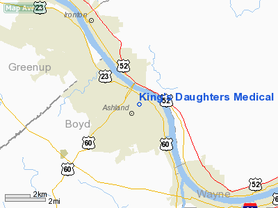
King's Daughters Medical Center Heliport |
|
|
|
Location &
QuickFacts
|
FAA
Information Effective: |
2008-09-25 |
|
Airport
Identifier: |
4KY9 |
|
Airport
Status: |
Operational |
|
Longitude/Latitude: |
082-38-06.0000W/38-28-15.0000N
-82.635000/38.470833 (Estimated) |
|
Elevation: |
625 ft / 190.50 m (Estimated) |
|
Land: |
0 acres |
|
From
nearest city: |
1 nautical miles N of Ashland, KY |
|
Location: |
Boyd County, KY |
|
Magnetic Variation: |
06W (2000) |
Owner & Manager
|
Ownership: |
Privately owned |
|
Owner: |
King's Daughters Medical Center |
|
Address: |
2201 Lexington Avenue
Ashland, KY 41101 |
|
Phone number: |
606-327-4618 |
|
Manager: |
Howard Harrison |
|
Address: |
2201 Lexington Avenue
Ashland, KY 41101 |
|
Phone number: |
606-327-4618 |
Airport
Operations and Facilities
|
Airport
Use: |
Private
MEDICAL USE. |
|
Wind
indicator: |
Yes |
|
Segmented Circle: |
No |
|
Control
Tower: |
No |
|
Lighting
Schedule: |
DUSK-DAWN |
|
Beacon
Color: |
Clear-Green-Yellow (heliport) |
|
Sectional chart: |
Cincinnati |
|
Region: |
ASO - Southern |
|
Boundary
ARTCC: |
ZID - Indianapolis |
|
Tie-in
FSS: |
LOU - Louisville |
|
FSS Toll
Free: |
1-800-WX-BRIEF |
|
Runway Information
Helipad H1
|
Dimension: |
43 x 43 ft / 13.1 x 13.1 m |
|
Surface: |
MATS,
ALUMINUM MATS. |
|
|
Runway H1
|
Runway
|
|
Traffic
Pattern: |
Left |
Left |
|
Radio Navigation Aids
|
ID |
Type |
Name |
Ch |
Freq |
Var |
Dist |
|
AJY |
FAN MARKER |
Ashland |
|
|
03W |
9.2 nm |
|
PMH |
NDB |
Portsmouth |
|
373.00 |
04W |
21.1 nm |
|
GAS |
NDB |
Gallipolis |
|
420.00 |
07W |
31.1 nm |
|
PZO |
NDB |
Peebles |
|
329.00 |
02W |
42.3 nm |
|
EOP |
NDB |
Waverly |
|
385.00 |
06W |
44.1 nm |
|
XW |
NDB |
Flmng |
|
400.00 |
05W |
48.0 nm |
|
AMT |
NDB |
West Union |
|
359.00 |
04W |
49.4 nm |
|
YRK |
VORTAC |
York |
075X |
112.80 |
05W |
19.2 nm |
|
ECB |
VORTAC |
Newcombe |
041X |
110.40 |
02W |
22.8 nm |
|
HNN |
VORTAC |
Henderson |
106X |
115.90 |
03W |
33.3 nm |
|
HVQ |
VORTAC |
Charleston |
121X |
117.40 |
03W |
41.4 nm |
|
CRW |
VOT |
Charleston Kanawha |
|
108.80 |
|
49.4 nm |
Remarks
-
PRVDD AREA IS MKD
& WIND INDICATOR IS MAINTAINED.
King's Daughters Medical Center Heliport
Address:
Boyd County, KY
Tel:
606-327-4618
Images
and information placed above are from
http://www.airport-data.com/airport/4KY9/
We
thank them for the data!
|
General Info |
| Country |
United
States |
| State |
KENTUCKY
|
| FAA ID |
4KY9
|
| Latitude |
38-28-15.000N |
|
Longitude |
082-38-06.000W |
|
Elevation |
625 feet
|
| Near
City |
ASHLAND
|
We don't guarantee the information is fresh and accurate. The data may
be wrong or outdated.
For more up-to-date information please refer to other sources.
|
|


