 |
|
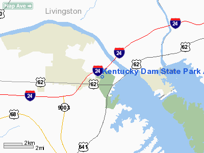
Kentucky Dam State Park Airport |
|
|
|
Location &
QuickFacts
|
FAA
Information Effective: |
2008-09-25 |
|
Airport
Identifier: |
M34 |
|
Airport
Status: |
Operational |
|
Longitude/Latitude: |
088-17-57.6000W/37-00-34.9000N
-88.299333/37.009694 (Estimated) |
|
Elevation: |
349 ft / 106.38 m (Surveyed) |
|
Land: |
208 acres |
|
From
nearest city: |
1 nautical miles NW of Gilbertsville, KY |
|
Location: |
Marshall County, KY |
|
Magnetic Variation: |
01E (1985) |
Owner & Manager
|
Ownership: |
Publicly owned |
|
Owner: |
Kentucky Dept. Of Parks |
|
Address: |
Capital Plaza Tower
Frankfort, KY 40601 |
|
Phone
number: |
502-564-2172 |
|
Manager: |
Mike Lee |
|
Address: |
Kentucky Dam St Pk; Box 69, 441 Airport Road
Gilbertsville, KY 42044 |
|
Phone number: |
270-362-4271
EXT 2377 |
Airport Operations and Facilities
|
Airport
Use: |
Open to public |
|
Wind
indicator: |
Yes |
|
Segmented Circle: |
No |
|
Control
Tower: |
No |
|
Lighting
Schedule: |
DUSK-DAWN
MIRL RY 09/27 PRESET MED INTST; TO INCREASE INTST & ACTVT REIL RYS 09
& 27 - CTAF. |
|
Beacon
Color: |
Clear-Green (lighted land airport) |
|
Landing
fee charge: |
No |
|
Sectional chart: |
St Louis |
|
Region: |
ASO - Southern |
|
Boundary
ARTCC: |
ZME - Memphis |
|
Tie-in
FSS: |
LOU - Louisville |
|
FSS on
Airport: |
No |
|
FSS Toll
Free: |
1-800-WX-BRIEF |
|
NOTAMs
Facility: |
LOU (NOTAM-d service avaliable) |
|
Federal Agreements: |
NGY |
Airport Communications
|
CTAF: |
122.800 |
|
Unicom: |
122.800 |
Airport Services
|
Airframe
Repair: |
NONE |
|
Power
Plant Repair: |
NONE |
|
Bottled
Oxygen: |
NONE |
|
Bulk
Oxygen: |
NONE |
|
Runway Information
Runway 09/27
|
Dimension: |
4000 x 100 ft / 1219.2 x 30.5 m |
|
Surface: |
ASPH, Good Condition |
|
Weight Limit: |
Single wheel: 12500 lbs. |
|
Edge Lights: |
Medium |
|
|
Runway 09
|
Runway 27
|
|
Longitude: |
088-18-22.0000W |
088-17-33.2000W |
|
Latitude: |
37-00-37.8000N |
37-00-32.0600N |
|
Traffic
Pattern: |
Left |
Left |
|
Markings: |
Non-precision instrument, Fair Condition |
Non-precision instrument, Fair Condition |
|
Crossing
Height: |
21.00 ft |
21.00 ft |
|
VASI: |
4-light PAPI on left side |
4-light PAPI on left side |
|
Visual
Glide Angle: |
4.00° |
4.00° |
|
Runway End
Identifier: |
Yes |
Yes |
|
Obstruction: |
8 ft trees, 233.0 ft from runway, 17 ft left of
centerline, 4:1 slope to clear |
73 ft trees, 976.0 ft from runway, 78 ft right of
centerline, 10:1 slope to clear |
|
Radio Navigation Aids
|
ID |
Type |
Name |
Ch |
Freq |
Var |
Dist |
|
BDD |
NDB |
Bellgrade |
|
254.00 |
00E |
19.6 nm |
|
GGK |
NDB |
Mayfield |
|
401.00 |
00E |
23.8 nm |
|
TWT |
NDB |
Tradewater |
|
276.00 |
00E |
32.2 nm |
|
CIR |
NDB |
Cairo |
|
397.00 |
00E |
44.4 nm |
|
FK |
NDB |
Airbe |
|
273.00 |
01W |
45.6 nm |
|
TIQ |
NDB |
Trainer |
|
410.00 |
00E |
46.0 nm |
|
HIX |
NDB |
Honey Grove |
|
356.00 |
01W |
46.8 nm |
|
HSB |
NDB |
Harrisburg-raleigh |
|
230.00 |
00E |
49.6 nm |
|
HXW |
TACAN |
Screaming Eagle |
096X |
|
01W |
43.6 nm |
|
CKV |
VOR/DME |
Clarksville |
043X |
110.60 |
01W |
48.6 nm |
|
CNG |
VORTAC |
Cunningham |
078X |
113.10 |
03E |
25.8 nm |
Remarks
-
DEER AND LARGE
FLOCKS OF GEESE ON AND INVOF ARPT.
-
EXISTED PRIOR TO 1959.
Based Aircraft
|
Aircraft based
on field: |
4 |
|
Single Engine
Airplanes: |
4 |
Operational Statistics
Time Period: 2005-02-02 - 2006-02-01
|
Aircraft
Operations: |
247/Week |
|
Air Taxi: |
2.3% |
|
General
Aviation Local: |
27.3% |
|
General
Aviation Itinerant: |
62.5% |
|
Military: |
7.8% |
Kentucky Dam State Park Airport
Address:
Marshall County, KY
Tel:
502-564-2172,
270-362-4271
Images
and information placed above are from
http://www.airport-data.com/airport/M34/
We
thank them for the data!
|
General Info |
| Country |
United
States |
| State |
KENTUCKY
|
| FAA ID |
M34
|
| Latitude |
37-00-34.201N |
|
Longitude |
088-17-45.119W |
|
Elevation |
349 feet
|
| Near
City |
GILBERTSVILLE |
We don't guarantee the information is fresh and accurate. The data may
be wrong or outdated.
For more up-to-date information please refer to other sources.
|
|


