 |
|
|
Location &
QuickFacts
|
FAA
Information Effective: |
2008-09-25 |
|
Airport
Identifier: |
75KY |
|
Airport
Status: |
Operational |
|
Longitude/Latitude: |
083-59-52.0000W/37-56-39.0000N
-83.997778/37.944167 (Estimated) |
|
Elevation: |
770 ft / 234.70 m (Estimated) |
|
Land: |
150 acres |
|
From
nearest city: |
9 nautical miles SE of Winchester, KY |
|
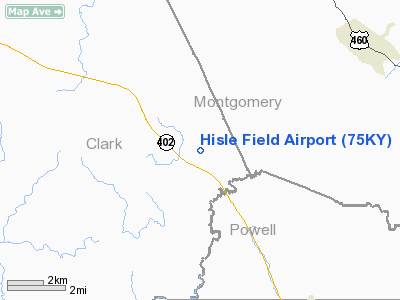
Location: |
Clark County, KY |
|
Magnetic Variation: |
04W (1990) |
Owner & Manager
|
Ownership: |
Privately owned |
|
Owner: |
Kenneth R Hisle |
|
Address: |
918 Kiddville Rd
Winchester, KY 40391 |
|
Phone number: |
606-842-4534 |
|
Manager: |
Kenneth R Hisle |
|
Address: |
918 Kiddville Rd
Winchester, KY 40391 |
|
Phone number: |
606-842-4534 |
Airport
Operations and Facilities
|
Airport
Use: |
Private |
|
Wind
indicator: |
Yes |
|
Segmented Circle: |
No |
|
Control
Tower: |
No |
|
Sectional chart: |
Cincinnati |
|
Region: |
ASO - Southern |
|
Boundary
ARTCC: |
ZID - Indianapolis |
|
Tie-in
FSS: |
LOU - Louisville |
|
FSS on
Airport: |
No |
|
FSS Toll
Free: |
1-800-WX-BRIEF |
|
Runway Information
Runway 02/20
|
Dimension: |
2800 x 70 ft / 853.4 x 21.3 m |
|
Surface: |
TURF, |
|
|
Runway 02
|
Runway 20
|
|
Traffic
Pattern: |
Left |
Left |
|
Obstruction: |
25 ft pline, 450.0 ft from runway |
|
|
Radio Navigation Aids
|
ID |
Type |
Name |
Ch |
Freq |
Var |
Dist |
|
IOB |
NDB |
Mount Sterling |
|
210.00 |
04W |
7.0 nm |
|
XYC |
NDB |
Seco |
|
393.00 |
03W |
11.3 nm |
|
LE |
NDB |
Blayd |
|
242.00 |
04W |
31.5 nm |
|
XW |
NDB |
Flmng |
|
400.00 |
05W |
41.3 nm |
|
FEU |
NDB |
Arnold |
|
521.00 |
03W |
42.2 nm |
|
DVK |
NDB |
Goodall |
|
311.00 |
03W |
42.6 nm |
|
FFT |
VOR |
Frankfort |
|
109.40 |
03W |
45.4 nm |
|
FLM |
VOR/DME |
Falmouth |
117X |
117.00 |
04W |
44.9 nm |
|
AZQ |
VOR/DME |
Hazard |
049X |
111.20 |
04W |
48.2 nm |
|
HYK |
VORTAC |
Lexington |
073X |
112.60 |
00E |
22.5 nm |
Remarks
Based Aircraft
|
Aircraft based
on field: |
6 |
|
Single Engine
Airplanes: |
1 |
|
Ultralights: |
5 |
Hisle Field Airport
Address:
Clark County, KY
Tel:
606-842-4534
Images
and information placed above are from
http://www.airport-data.com/airport/75KY/
We
thank them for the data!
|
General Info |
| Country |
United
States |
| State |
KENTUCKY
|
| FAA ID |
75KY
|
| Latitude |
37-56-39.000N |
|
Longitude |
083-59-52.000W |
|
Elevation |
770 feet
|
| Near
City |
WINCHESTER |
We don't guarantee the information is fresh and accurate. The data may
be wrong or outdated.
For more up-to-date information please refer to other sources.
|
|


