 |
|
Cynthiana-Harrison County Airport |
| Cynthiana-Harrison County Airport |
| IATA: none â ICAO: none â FAA LID: 0I8 |
| Summary |
| Airport type |
Public |
| Owner |
Cynthiana-Harrison County Airport Board |
| Serves |
Harrison County |
| Location |
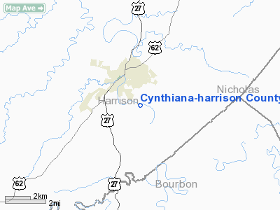
Cynthiana, Kentucky |
| Elevation AMSL |
721 ft / 220 m |
| Coordinates |
38°21â²58â³N 084°17â²00â³W / 38.36611°N 84.2833333°W / 38.36611; -84.2833333 |
| Website |
www.ky0i8.com |
| Runways |
| Direction |
Length |
Surface |
| ft |
m |
| 11/29 |
3,852 |
1,174 |
Asphalt |
| Statistics (2008) |
| Aircraft operations |
8,530 |
| Based aircraft |
30 |
| Source: Federal Aviation Administration |
Cynthiana-Harrison County Airport (FAA LID: 0I8) is a public use airport located two nautical miles (3.7 km) south of the central business district of Cynthiana, in Harrison County, Kentucky, United States. It is owned by the Cynthiana-Harrison County Airport Board.
Facilities and aircraft
Cynthiana-Harrison County Airport covers an area of 86 acres (35 ha) at an elevation of 721 feet (220 m) above mean sea level. It has one asphalt paved runway designated 11/29 which measures 3,852 by 75 feet (1,174 x 23 m).
For the 12-month period ending November 28, 2008, the airport had 8,530 aircraft operations, an average of 23 per day: 94% general aviation, 4% air taxi and 2% military. At that time there were 30 aircraft based at this airport: 77% single-engine, 10% multi-engine and 13% ultralight.
The above content comes from Wikipedia and is published under free licenses – click here to read more.
|
Location &
QuickFacts
|
FAA
Information Effective: |
2008-09-25 |
|
Airport
Identifier: |
0I8 |
|
Airport
Status: |
Operational |
|
Longitude/Latitude: |
084-17-00.0400W/38-21-58.1900N
-84.283344/38.366164 (Estimated) |
|
Elevation: |
721 ft / 219.76 m (Surveyed) |
|
Land: |
56 acres |
|
From
nearest city: |
2 nautical miles S of Cynthiana, KY |
|
Location: |
Harrison County, KY |
|
Magnetic Variation: |
03W (1985) |
Owner & Manager
|
Ownership: |
Publicly owned |
|
Owner: |
Cynthiana-harrison Co Arpt Bd |
|
Address: |
P.o. Box 395
Cynthiana, KY 41031 |
|
Phone
number: |
859-234-5533
AIRPORT BOARD CHAIRMAN: BOBBY CRAFT. |
|
Manager: |
Richard Carl |
|
Address: |
582 Airfield Lane
Cynthiana, KY 41031 |
|
Phone number: |
859-234-8477 |
Airport
Operations and Facilities
|
Airport
Use: |
Open to public |
|
Wind
indicator: |
Yes |
|
Segmented Circle: |
Yes |
|
Control
Tower: |
No |
|
Lighting
Schedule: |
DUSK-DAWN
MIRL RY 11/29 PRESET LOW INTST; TO INCR INTST AND ACTVT SAVASI RYS 11
& 29 AND REIL RYS 11 & 29 - 122.9. |
|
Beacon
Color: |
Clear-Green (lighted land airport) |
|
Landing
fee charge: |
No |
|
Sectional chart: |
Cincinnati |
|
Region: |
ASO - Southern |
|
Boundary
ARTCC: |
ZID - Indianapolis |
|
Tie-in
FSS: |
LOU - Louisville |
|
FSS on
Airport: |
No |
|
FSS Toll
Free: |
1-800-WX-BRIEF |
|
NOTAMs
Facility: |
LOU (NOTAM-d service avaliable) |
|
Federal Agreements: |
NY1 |
Airport Communications
|
CTAF: |
122.800 |
|
Unicom: |
122.800 |
Airport Services
|
Fuel
available: |
100LL80 |
|
Airframe
Repair: |
MINOR |
|
Power
Plant Repair: |
MINOR |
|
Bottled
Oxygen: |
NONE |
|
Bulk
Oxygen: |
NONE |
|
Runway Information
Runway 11/29
|
Dimension: |
3852 x 75 ft / 1174.1 x 22.9 m |
|
Surface: |
ASPH, Fair Condition |
|
Weight Limit: |
Single wheel: 16000 lbs.
Dual wheel: 25000 lbs. |
|
Edge Lights: |
Medium |
|
|
Runway 11
|
Runway 29
|
|
Longitude: |
084-17-23.3400W |
084-16-36.7400W |
|
Latitude: |
38-22-03.2800N |
38-21-53.0900N |
|
Elevation: |
720.00 ft |
720.00 ft |
|
Alignment: |
106 |
127 |
|
Traffic
Pattern: |
Left |
Left |
|
Markings: |
Basic, Good Condition |
Basic, Good Condition |
|
Crossing
Height: |
41.00 ft |
33.00 ft
TCH 33 FT OVER DSPLCD THLD. |
|
Displaced
threshold: |
0.00 ft |
1095.00 ft |
|
VASI: |
2-box SAVASI on left side |
2-box SAVASI on left side |
|
Visual
Glide Angle: |
4.50° |
5.00° |
|
Runway End
Identifier: |
Yes |
Yes |
|
Obstruction: |
36 ft rr, 800.0 ft from runway, 185 ft right of
centerline, 16:1 slope to clear |
85 ft trees, 800.0 ft from runway, 100 ft right of
centerline, 7:1 slope to clear
APCH RATIO 20:1 TO DSPLCD THLD. |
|
Decleard
distances: |
Take off run available 2757.00 ft
Take off distance available 3852.00 ft
Actual stop distance available 3852.00 ft
Landing distance available 3852.00 ft |
Take off run available 3852.00 ft
Take off distance available 3852.00 ft
Actual stop distance available 3852.00 ft
Landing distance available 2757.00 ft |
|
Radio Navigation Aids
|
ID |
Type |
Name |
Ch |
Freq |
Var |
Dist |
|
IOB |
NDB |
Mount Sterling |
|
210.00 |
04W |
23.3 nm |
|
FEU |
NDB |
Arnold |
|
521.00 |
03W |
26.9 nm |
|
LE |
NDB |
Blayd |
|
242.00 |
04W |
28.9 nm |
|
XW |
NDB |
Flmng |
|
400.00 |
05W |
32.4 nm |
|
XYC |
NDB |
Seco |
|
393.00 |
03W |
38.5 nm |
|
PWF |
NDB |
Sportys |
|
245.00 |
04W |
42.8 nm |
|
AMT |
NDB |
West Union |
|
359.00 |
04W |
44.8 nm |
|
UR |
NDB |
Burln |
|
321.00 |
04W |
46.9 nm |
|
LUK |
NDB |
Cincinnati |
|
335.00 |
04W |
47.8 nm |
|
FFT |
VOR |
Frankfort |
|
109.40 |
03W |
31.5 nm |
|
FLM |
VOR/DME |
Falmouth |
117X |
117.00 |
04W |
17.1 nm |
|
HYK |
VORTAC |
Lexington |
073X |
112.60 |
00E |
25.6 nm |
|
CVG |
VORTAC |
Cincinnati |
120X |
117.30 |
04W |
43.7 nm |
|
LUK |
VOT |
Cincinnati Muni/lunken |
|
108.40 |
|
45.4 nm |
Remarks
Based Aircraft
|
Aircraft based
on field: |
26 |
|
Single Engine
Airplanes: |
19 |
|
Multi Engine
Airplanes: |
1 |
|
Ultralights: |
6 |
Operational Statistics
Time Period: 2005-02-24 - 2006-02-23
|
Aircraft
Operations: |
193/Week |
|
Air Taxi: |
3.3% |
|
General
Aviation Local: |
44.9% |
|
General
Aviation Itinerant: |
49.9% |
|
Military: |
2.0% |
Cynthiana-harrison County Airport
Address:
Marion County, FL
Tel:
Images
and information placed above are from
http://www.airport-data.com/airport/0I8/
We
thank them for the data!
|
General Info |
| Country |
United
States |
| State |
KENTUCKY
|
| FAA ID |
0I8
|
| Latitude |
38-22-00.270N |
|
Longitude |
084-17-02.762W |
|
Elevation |
722 feet
|
| Near
City |
CYNTHIANA |
We don't guarantee the information is fresh and accurate. The data may
be wrong or outdated.
For more up-to-date information please refer to other sources.
|
|


