 |
|
|
Location &
QuickFacts
|
FAA
Information Effective: |
2008-09-25 |
|
Airport
Identifier: |
95KY |
|
Airport
Status: |
Operational |
|
Longitude/Latitude: |
084-22-09.0000W/37-25-13.0000N
-84.369167/37.420278 (Estimated) |
|
Elevation: |
1227 ft / 373.99 m (Surveyed) |
|
Land: |
0 acres |
|
From
nearest city: |
3 nautical miles NE of Brodhead, KY |
|
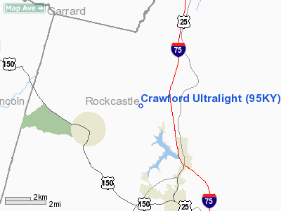
Location: |
Rockcastle County, KY |
|
Magnetic Variation: |
03W (1990) |
Owner & Manager
|
Ownership: |
Privately owned |
|
Owner: |
Robert H. Crawford |
|
Address: |
1991 Mt Zion Rd
Brodhead, KY 40409 |
|
Phone
number: |
606-758-8181 |
|
Manager: |
Robert H. Crawford |
|
Address: |
1991 Mt Zion Rd
Brodhead, KY 40409 |
|
Phone number: |
606-758-8181 |
Airport Operations and Facilities
|
Airport
Use: |
Private |
|
Segmented Circle: |
No |
|
Control
Tower: |
No |
|
Sectional chart: |
Cincinnati |
|
Region: |
ASO - Southern |
|
Boundary
ARTCC: |
ZID - Indianapolis |
|
Tie-in
FSS: |
LOU - Louisville |
|
FSS on
Airport: |
No |
|
FSS Toll
Free: |
1-800-WX-BRIEF |
|
Runway
Information
Runway 05U/23U
|
Dimension: |
1880 x 70 ft / 573.0 x 21.3 m |
|
Surface: |
TURF, |
|
|
Runway 05U
|
Runway 23U
|
|
Traffic
Pattern: |
Right |
Left |
|
Radio Navigation Aids
|
ID |
Type |
Name |
Ch |
Freq |
Var |
Dist |
|
DVK |
NDB |
Goodall |
|
311.00 |
03W |
21.0 nm |
|
XYC |
NDB |
Seco |
|
393.00 |
03W |
25.9 nm |
|
CDX |
NDB |
Cumberland River |
|
388.00 |
05E |
29.5 nm |
|
LE |
NDB |
Blayd |
|
242.00 |
04W |
36.8 nm |
|
EKQ |
NDB |
Elk Spring |
|
290.00 |
03W |
41.1 nm |
|
TYC |
NDB |
Taylor County |
|
272.00 |
02W |
41.8 nm |
|
IOB |
NDB |
Mount Sterling |
|
210.00 |
04W |
42.6 nm |
|
IKY |
NDB |
Springfield |
|
429.00 |
03W |
43.3 nm |
|
LOZ |
VORTAC |
London |
108X |
116.10 |
03W |
26.4 nm |
|
HYK |
VORTAC |
Lexington |
073X |
112.60 |
00E |
33.2 nm |
Remarks
Based Aircraft
|
Aircraft based
on field: |
3 |
|
Single Engine
Airplanes: |
3 |
Crawford Ultralight
Address:
Rockcastle County, KY
Tel:
606-758-8181
Images
and information placed above are from
http://www.airport-data.com/airport/95KY/
We
thank them for the data!
|
General Info |
| Country |
United
States |
| State |
KENTUCKY
|
| FAA ID |
95KY
|
| Latitude |
37-25-13.000N |
|
Longitude |
084-22-09.000W |
|
Elevation |
1227
feet |
| Near
City |
BRODHEAD
|
We don't guarantee the information is fresh and accurate. The data may
be wrong or outdated.
For more up-to-date information please refer to other sources.
|
|


